
User Manual


Working with Terminal Charts
159
Clearance, Radar Vectoring
Area, Control Area (CTA),
Terminal Control Area (TMA),
Climb/Descend Areas,
Approach Control Area
Standard Instrument Departure
(SID)>
Noise — Noise Abatements,
Preferred Runways and Flight
Paths
Approach — ILS, RNAV, VOR
Runways
Text — Special Notes
European VFR Icons
VFR Airport
Airport — VFR Aerodrome
Landing Chart
Airspace — VFR Area Chart
and Information, VFR Visual
Reference Points
Text — VFR General
Aerodrome Information, VFR
Text Day, VFR Text Night, VFR
Departure
Approach — VFR Approach
chart
Displaying Terminal Chart Changes
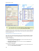
Besides the chart type, the icon depicts the effectivity of the chart. When a chart is
not current; a green or red dot indicates the chart effective status as shown below.
Terminal chart changes are one of two categories:
• Changes that are effective immediately upon receipt of a CD or an
available download — Most chart changes are of this category. When an
airport is expanded in the Airport List to reveal its terminal charts, the dates
that appear in the City column are revision dates, and should not be confused
with an "effective" date.
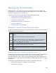
The terminal charts seen below were downloaded from the Internet on January
26th. The date specified under the City column - 26 Jan 2007 - is the revision
date. The charts are effective upon receipt and appropriate to use during
flight.