User Guide 4.
Contents: Typographic conventions...................................................................................4 Icons.................................................................................................................. 5 Introduction........................................................................................................ 6 Key features.................................................................................................. 6 Getting started.........................
Route options.......................................................................................... 32 Volume.................................................................................................... 34 Optional features............................................................................................. 35 Guides......................................................................................................... 35 Traffic Message Channel (TMC).....................................
TYPOGRAPHIC CONVENTIONS Bold Items you must select, such as menu options, command buttons, or items in a list. • Bullet Step-by-step procedures. You can follow these instructions to complete a specific task. Comment Especially important or noteworthy information. Monospace Information that you must type, or information like folders and filenames. CAPITALS Names of keys on the keyboard. For example, SHIFT, CTRL, or ALT.
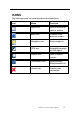
ICONS The following icons are used throughout the application: Icon Name Function Menu icon Open a menu with various options. Back icon Go back to the previous screen. Navigation icon Start navigation. GPS icon Availability/strength of GPS signal. Search icon Open a search screen Confirmation icon Apply settings. Select/deselect all. Cancel icon Cancel route calculation. ©Keomo B.V., 2007. All rights reserved.
INTRODUCTION You have chosen a cutting-edge navigation system. Please enjoy using it. This navigation system leads you straight to your destination, whether you are travelling by car or on foot. You can navigate and plan your route with an easy to use and intuitive interface, just by using your finger. You can also use this application to plan your trip to suit your personal preferences and interests and to find and save interesting destinations before you set off on your journey.
GETTING STARTED Please make sure that the battery in your device is fully charged. • Switch on the unit and tap on NAVI or NAVIGATION in the first screen. Choosing a language If more than one language is available on your device, you will be prompted to choose the desired language. • Click on the flag representing the desired country/language. • On the following screen, choose the voice skins used for the voice commands during navigation (e.g. female or male voice).
GPS connection Your PND uses Global Positioning System (GPS) technology for navigation. The device receives signals from a number of GPS satellites in order to determine your current position. • Place your PND in a location with an unobstructed view to the sky to set up your first satellite connection. In a car this will usually be on the dashboard. It may take up to 5 minutes to establish the first connection.
MAIN ELEMENTS Main menu The main menu is your central point of access to all functions of your Personal Navigation Device. It allows you to find and set your destination, manage your favourites and control all settings of your device. On the left hand panel, there are three buttons.
• Use Settings to configure your Personal Navigation Device to suit your needs. Define general settings (e.g. time, language, system of measurement, see page 29), configure your map (e.g. 2D or 3D mode, day or night mode, map complexity) or load a map of a different region (see page 30), set the route options (e.g. choose to avoid or allow toll roads or ferries or select your mode of transportation; see page 29), or adjust the volume (see page 34).
Back icon Info box: name of current position Menu icon As soon as you browse the map, you enter the browsing mode: GPS status Battery status Zoom out Cursor GPS position Zoom in Back icon • Info box: name of current position Menu icon Use a pen or your finger to browse the map. The selected position will be identified by a cursor. Clicking on an icon on the map will open an overlay window with information about the selected item. • To zoom in or out, press the + or - icons.
Speed Estimated arrival time Zoom out Distance to destination Direction Position Position Zoom Back icon Info box: name of current position Menu icon The navigation screen displays your route (in blue) and your surroundings. The GPS position symbol identifies your current position. The red arrow indicates the direction of your next turn. The upcoming manoeuvre is always displayed in the upper left corner – together with the distance to it.
MAIN FEATURES This chapter describes the functions of your Personal Navigation Device in detail. On the following pages you will learn how to - Find and choose locations (see page 13) - Navigate to your destination (see page 24) - Use the route planner (see page 26) - Configure the application (see page 29) Choosing and finding locations This section describes the different ways of finding and choosing locations.
The Find Address window will be displayed: • Enter the appropriate data to find your address. How to search Your Personal Navigation Device offers a convenient interactive look-ahead search function to prevent misspelling. Only keys that lead to a search result can be pressed – all others are inactive! • Enter the first two characters. You will see that the some keys on the keypad turn inactive. You can only choose active keys: ©Keomo B.V., 2007. All rights reserved.
• Enter the second character. Again, some keys will turn inactive; others will turn active, depending on your choice. • Keep on entering characters until you have narrowed down the search to only one result. • Press the search icon (magnifying glass). OR A result list will be displayed. • Choose the appropriate entry from the list. Switch between letter and number mode by pressing 123 or ABC. Switch between upper case and lower case by pressing ^.
Set the country • To select your country, press State/Prov.. • Choose your country from the list. The State/Prov. field will be populated with the name of the chosen country. Enter a post code Instead of a city you may enter a post code. • To enter a post code, press Post Code. • Enter the post code of the town/city you are looking for. • Press the search icon (magnifying glass). A hit list will be displayed. • Choose the appropriate town/city from the list.
A result list will be displayed. • Choose the appropriate street from the list. You will return to the Find Address screen. It will be filled with the data previously entered. You may also enter the number. Navigate to the address found Once you have narrowed down your search to a unique address, you can start navigation. Press the menu icon to access further options: • To navigate to the location, press Navigate (see page 24). • To use the location for planning a route, press Via (see page 26).
Searching for and choosing POIs The POI finder allows you to quickly find points of interest like petrol stations and restaurants in a database of millions of POIs. These places can be nearby or at a remote location. Where? displays the starting point for the search. POIs near that point will be displayed. This is usally your current location. To set a starting point other than your current location, press Where?. • In the main menu, press Destination. • Press POI Search.
• Select a POI by clicking on it. A menu with a set of actions will be displayed: • To navigate to the location, press Navigate (see page 24). • To use the location for planning a route, press Via (see page 26). • To save the location as a bookmark, press Save (see page 20). • To show the location on the map, press On Map. • To show information about the location (if available), press Description. Searching for a POI • To enter a search keyword, press the search icon.
A menu with a set of actions will be displayed, as described above. Choosing a location on the map An easy way to choose a location is selecting it on the map. Browse your surroundings and choose any street or location to use it for navigation or routing. • In the main menu, press Destination. • In the main menu, press Map. • Point the cursor at any place on the map. The name of a selected location/street will be shown in the info box. • Press the menu icon.
The Favourites menu will show on the screen: Bookmarks The bookmarks list contains the destinations you have saved as favourites (from the guides, by choosing it on a map, etc.). This means that you do not need to perform repeated searches for those destinations. • Press Bookmarks. ©Keomo B.V., 2007. All rights reserved.
The bookmark list will show on the screen: Use the up and down arrows to scroll up and down in the list. • Select an item by clicking on it. A menu with a set of actions will be displayed: • To navigate to the location, press Navigate (see page 24). • To use the location for planning a route, press Via (see page 26). • To sort the list of location alphabetically, press Sort. • To show the location on the map, press On Map. • To delete the selected location, press Delete.
The list of recent locations will show on the screen. Use the up and down arrows to scroll up and down in the list. • Select an item by clicking on it. A menu with a set of actions will be displayed, as described above. The available options may vary. Trips • To access to your previously saved trips, i.e. routes, press pressing Trips (see page 26 for more information about setting trips). Presets You can save your home and street addresses as presets for quick access. • Press Home and Work.
Navigating The powerful navigation capabilities of your Personal Navigation Device guide you along the shortest or quickest route from A to B – with voice commands and in 3D. This section describes the navigation feature. See page 20 for information about choosing elements on the map. See page 13 for information about finding and choosing addresses, POIs, and locations inside a guide. • Choose a location through Destination, and press Navigate in the respective menu. Your route will be calculated.
Menu options • To open a set of navigation options during navigation, press the menu icon: Here you will find the following items: Alt. route With this option, you can choose to block the calculated route for a given distance (e. g. 0.5 km) and force an alternative route. Simply tap on the icon which shows the desired distance. Your route will be recalculated, and the previous route will be discarded for the given distance. List of waypoints Opens a list of the waypoints (manoeuvres) along your route.
You can redirect your route by choosing a point of interest (POI), like a petrol station. Redirecting means either setting a new destination or adding a new stopover. Settings Change the settings of your Personal Navigation Device, as described on page 29. Planning a route This section describes the route planning feature. This feature allows you to plan your route in advance, choosing multiple stopovers along your journey. See page 20 for information about choosing elements on the map.
The location will be added to the Destination List. • To add another stopover, press the + icon. You will switch to the Choose stopover: screen. You may choose stopovers like your home or work addresses, a bookmark, a point of interest, a recent location or by searching for an address or pinpointing a destination on the map. Once you have added stopovers (with the + icon) and returned to the Destination List, you have several options: ©Keomo B.V., 2007. All rights reserved.
• With the + icon you can choose additional stopovers. You can add up to six stopovers. • To change the order of the stopovers, select a stopover and then use the up and down arrows to move it up/down in the list. • With the trash icon you can delete a selected stopover. Once you have chosen your route, you have several options. You reach those options by pressing the menu icon (bottom right-hand corner of the screen). • To simulate the route to come, press Simulate.
Settings You can configure your Personal Navigation Device to suit your needs. When it comes to navigating, you can, for example, choose to avoid or allow toll roads or ferries or select your mode of transportation, like a fast or slow car, a scooter or even your own feet. You can also edit several display settings, such as 2D or 3D mode, day or night mode, map complexity, etc. • In the main menu, press Settings. General settings • Choose General to change the general settings. ©Keomo B.V., 2007.
The window with the general settings will be shown: • To choose the language, press Language. • To change the time zone, press Set time. • To change the system of measurement, press Miles or Kilometres. • To show information about the application, press About. Map settings • Choose Map Settings to change the map settings. ©Keomo B.V., 2007. All rights reserved.
The window with the map settings will be shown: • To toggle between night and day modes, press the corresponding icon. By selecting Automatic, the mode will be chosen depending on the actual time. • To select a map, press Maps. If you have map data for different regions/cities on your memory card, tap on the name of the current region (e. g. London). All available maps on the memory card will be listed. You can choose the desired region by simply tapping on its name.
• To select which kinds of elements will be displayed on the map, press Info Layers: • Check the boxes of any category you want to have displayed on the map. Uncheck those that should be hidden. This will have no impact on any search you perform. • To apply your settings, press the confirmation icon. • To return to the previous screen, press the arrow. Route options • Choose Route Settings to change the route options. ©Keomo B.V., 2007. All rights reserved.
The window with the route settings will be displayed: • To switch between the modes just touch the icons. These will toggle so you can quickly see the activated settings. You can choose among the following options: Mode of transportation (fast car, slow car, motorbike, pedestrian, etc.), fastest or shortest route, allow or avoid toll roads, motorways, and ferries. You can also choose the distance unit (miles/kilometres).
Motorbike – takes into account motorbike restrictions, where applicable. Scooter – takes into account scooter restrictions, where applicable. Van – takes into account van restrictions, where applicable. Pedestrian – provides true pedestrian routing including full access to one-way streets and pedestrian zones, where possible. There will be no voice commands. The estimated arrival time calculated during navigation will be calculated taking into account these settings.
OPTIONAL FEATURES The features described in this chapter are optional, i.e. they are not necessarily part of your Personal Navigation device. The features include the following: • Guides • Traffic Message Channel (TMC) • Speed Camera Alert Guides The guides are valuable information services, including directory services, WiFi hotspot locators, and city guides. City guides contain detailed information about locations, such as descriptions, contact information, prices, opening times, etc.
With the Automatic option, your Personal Navigation Device will automatically guide you around all the traffic jams on your route. With the Manual option your navigation system will alert you about traffic jams and ask you if you would like to switch to an alternate route. During navigation and in the tracking mode, you can also choose to show a list of upcoming traffic jams. • Press the menu icon. The route options screen will be displayed. • To show a list of traffic jams, press Traffic Info..
FREQUENTLY ASKED QUESTIONS I can’t find an address. Please make sure you have correctly spelled your entry. If you do not know how an address is spelled correctly, simply enter the parts of the address, you know for sure (e.g. “Lond”, “Leic” for Leicester Square in London). Then browse in the result list and look for the address. Also make sure that the city in which you are looking for an address is correct. Sometimes the official postal address differs from the address you are looking for.
INDEX A N Alternative route............................... Enforce.................................... 25 B Navigate........................................... Command....................17, 19, 22 Navigation.................................... 24 Navigation screen......................... 12 Browsing mode............................. 11 O C On Map............................................ Command............................... 17 Choose destination........................... Recent locations ...
V Via Command..............17, 19, 22, 23 W Waylist.............................................. Route planning........................ 28 ©Keomo B.V., 2007. All rights reserved.
COPYRIGHT AND LICENSE NOTES Copyright for this manual: © Keomo B.V., 2007. All rights reserved. Portions of the software are copyright © 1996-2002 The FreeType Project (www.freetype.org). All rights reserved. ©Keomo B.V., 2007. All rights reserved.