
User Manual

31
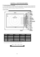
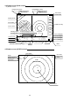
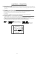
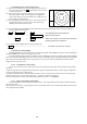
4.6 Radar screen (All PPI /PPI screen)
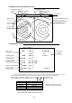
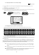
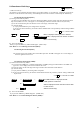
4.7 Navigation screen
To show the NAV display, you need to connect a GPS receiver to your radar. The NAV display shows the
position and cruising speed of your ship, seawater temperature, and other navigation information.
Note: Heading angle will be displayed "COG" when Course Over Ground data is used.
Note: Cruising speed will be displayed "SOG" when Speed Over Ground data is used.
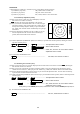
Deviation from
Indication mark
0.00
--
><
0.02
--
>
or
<
0.04
--
>>
or
<<
0.08
--
>>>
or
<<<
0.16
--
>>>>
or
<<<<
Tab.6 Indication of deviation from course
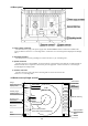
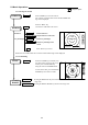
Picture hold
Guard zone(Right screen)
Guard zone(Left screen)
6
1.0_ HU L GZ IN
.75
.25 GZ IN HOLD
Range(Left screen) Range(Right screen)
Range ring interval Range ring interval
(Left screen) (Right screen)
+
Display mode
Pulse width
Cross cursor
NAV DISPLAY
WP 134.4° COURSE
12.5
NM
>>>
HDG 129.0° 0.23
NM
SPD 12.8
KT
LAT 35° 08.42N
LON 139° 02.53E
TEMP 20.5°
C
DEPTH 93.2
M
ST’BY
Way point
Heading angle
Cruising speed
Current position
Sea water temperature
Depth of water
Course error
(XTE)
> Indicates starboarding the helm
< Indicates porting the helm (left)