
Item Brochure
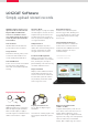

LOGiCAT Software
Simply upload stored records
Digisystem Accessories
Signal Clamp (33kHz)
100 mm clamp used in conjunction
with the Digitex signal transmitter,
with a 33 kHz output, to apply a
traceable signal to conductive buried
utilities such as cables or pipes.
Property Connection Set
For use with the Digitex signal
transmitter.
Connection of a tracing signal to any
internal power distribution system
outlet.
Digimouse Standard Sonde
(8 kHz & 33 kHz)
Compact dual frequency sonde used to
trace drains, sewers and other non-con-
ductive utilities. Digimouse can be
attached to a range of equipment includ-
ing drain rods, boring tools and inspection
cameras. Powered by 1x AA alkaline
battery, with a depth range of 5 metres.
LOGiCAT software allows you to
upload stored records from the
Digicat 600i and 700i Series
locators. To view the locators
use, simply upload all records or
search by date. Upload informa-
tion includes:
Time and Date
Identifies when and at what time
ground surveys were conducted.
Usage Duration
Determines how long survey teams
searched for buried utilities and
reveals actual product utilisation.
User Identification
Forces users to become accountable
for their actions and identifies
those who need additional product
training.
Detection Mode
Allows managers to judge the quality
and thoroughness of work. As more
comprehensive ground surveys are
conducted the locator records the
mode of operation including the use
of a signal transmitter.
Utility Detection
Discovers quickly if any buried
utilities were detected during surveys
and even determines the signal
strength shown on the locator.
Product Fleet Management
Displays and monitors the service
and calibration dates of your locator
fleet, ensuring they are kept in
perfect working order and not being
used when calibration is due.
Diagnostic Check
Displays locators which have failed
the EST (Extended Self Test) and
removes them from the active fleet
for immediate repair. This reduces
the possibility of defective equip-
ment being used on-site.
Management Reports
Produces basic statistical reports
from the logged data, allowing users
to see how products are utilised and
how ground survey teams are using
them on-site.
Integrated GPS Technology*
Provides information on where the
locator has been used and when
downloaded into LOGiCAT the data is
displayed visually in an easy to
understand map.
LOGiCAT Software Art. No. 795945
* Only available on Digicat 750i