
Product Manual
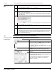

Leica DM2000, Software
26
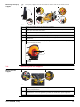
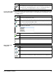
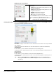
Map Section
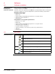
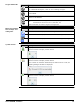
Radargrams
Shallow: 700 MHz radargram
Deep: 250 MHz radargram
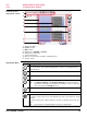
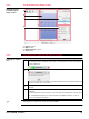
Acquisition
Commands
a) Compass
b) Loaded map layers
c) Current position of the DS2000 radar
d) Inserted target
e) Scan line
a) Horizontal scale (distance travelled). The
yellow line indicates the current position of
the DS2000
b) Real-time visualisation of the scan data
c) Vertical scale (depth)
Click and drag the scroll bar to scroll horizontally through the scan data of the radar-
grams.
012462_001
a
c
b
e
d
012352_001
a
b
c
Button Description
Click this button to choose the scan direction before starting an acquisi-
tion. (Shortcut: F2)
Forward: to push the DS2000.
Backward: to pull the DS2000.
Click this button to start an acquisition. (Shortcut: F1)
Click this button to stop and save the acquisition. (Shortcut: F1)
During the scan, the software evaluates the scan data from the
previous half-meter. Based on the detected soil characteristics,
the software calculates the best graphic settings for the radar-
grams and continually adjusts them. If the soil characteristics
change suddenly, the software is not able to adjust the graphic
settings properly.
Click this button to refresh the graphic settings of the radargrams.