
Operation Manual


32 User Manual
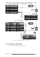
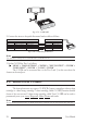
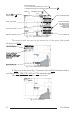
Cursor or Ship Coordinates
Speed Over Ground
Course Over Ground
Distance and Bearing
from Ship to Cursor
(from Ship to Target
if Target is set,
from Ship to MOB
if MOB is set)
Chart Scale
Map Datum selected
Charting or Navigation (Home)
- if fix is not received the following icon is shown:
- if a Differential GPS signal is received the following icon is shown:
Fix received Indication
Ship icon (if in Charting the
displayed icon is )
Fig. 3.1.1 - Charts and text area page
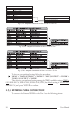
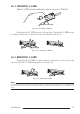
The second is with text area on the bottom line of the screen (with partial
information on SOG):
Fig. 3.1.1a - Charts and text windows
If Target is set, in the previous Fig. 3.1.1a instead of the only SOG information window,
a text line with DST, BRG, XTE, SOG and TTG information appears.
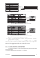
Then it is possible to see on the screen only charts:
Fig. 3.1.1b - Full charts