
Operation Manual

48 User Manual
Intertidal, Depth Area, Rocks, Obstructions, Shoreline Constructions, Fishing
Facility, Wrecks, Dragged area, Diffusion area, Mooring facilities, Pingos and
Production installations.
Caution
Red when “Guardian Technology” detects cautionary or restricted area.
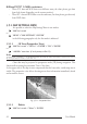
3.5.1.9 Satellite Imagery
'MENU' + "MAP SETTINGS" +'ENTER' + "SATELLITE IMAGERY" + 'ENTER'
It is possible to overlay the Satellite image for background map. When it is set On,
the Palette is set to Normal to display the proper colors.
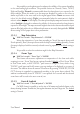
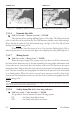
3.5.1.10 Currents Prediction
'MAP' for 1 second + "Currents Prediction" + 'ENTER'
It is possible to see the variation of the Tidal arrows on the selected area at any
given time. A window is shown on the low-left side of the chart, press 'ENTER' to set the
date and time manually, 'MENU' to decrease time and 'GOTO' to increase time. Press
'CLEAR' to exit.
3.5.1.11 Selecting the C
HART
Language
'MENU' + "MAP SETTINGS" +'ENTER' + "Chart Language" + 'ENTER'
The possible choices are:
Language: Allows setting the language to display chart information. The language is chosen
among the list of languages available on the cartographic data (C-CARD or embedded
charts).
'MENU' + "MAP SETTINGS" +'ENTER' + "Chart Language" + 'ENTER' + "Lan-
guage" + 'ENTER'
Mode: Defines how objects are translated. It is possible to choose between the three following
options:
• OFF : Uses the same Language used for LANGUAGE. If the selected
language is not present on the objects information, English is used
instead.
• ENGLISH : Always uses English.
• LOCAL : Uses the first Local language present on data. If no Local language
is available, English is used instead.
'MENU' + "MAP SETTINGS" +'ENTER' + "Chart Language" + 'ENTER' + "Mode"
+ 'ENTER'
Note
a. When User Interface Language is changed, Chart Language settings are set as follows: MODE is
set to Off and Chart Language is set as the User Interface Language selection if available on the chart
data, otherwise is set to English.