GlobalNav 310 TM INSTALLATION AND OPERATION INSTRUCTIONS
Copyright © 1997 Lowrance Electronics, Inc. All rights reserved. GlobalNav 310™ is a trademark of Lowrance Electronics, Inc. Lowrance® is a registered trademark of Lowrance Electronics, Inc. WARNING! USE THIS UNIT ONLY AS AN AID TO NAVIGATION. A CAREFUL NAVIGATOR NEVER RELIES ON ONLY ONE METHOD TO OBTAIN POSITION INFORMATION. Never use this product while operating a vehicle. CAUTION When showing navigation data to a position (waypoint), this unit will show the shortest, most direct path to the waypoint.
INTRODUCTION .......................................................................................................... 1 INSTALLATION .............................................................................................................. 2 BRACKET INSTALLATION ....................................................................................... 2 POWER CABLE ....................................................................................................... 4 ANTENNA ...........................
NAVIGATION ................................................................................................................. 35 NAVIGATE TO A WAYPOINT ................................................................................... 35 NAVIGATE TO A CURSOR LOCATION ................................................................... 35 NAVIGATING TO A WAYPOINT USING THE PLOTTER ......................................... 36 CANCEL NAVIGATION ...................................................................
Congratulations! You have purchased one of the finest 12-channel GPS receivers Lowrance ® has ever made. With its large LCD screen, easy to use menus, and outstanding performance, we think you’ll be happy with your GlobalNav 310™ for many years. GPS works from satellites that transmit information to the world at very high frequencies. One disadvantage to this frequency is that it’s “line-ofsight”. In other words, the signals don’t bounce around like your local radio or television.
Even with S/A on, and without a DGPS receiver, your GlobalNav 310 gives you outstanding position and navigation information. Please sit down with the unit and this manual and familiarize yourself with them before using the GlobalNav 310 in the “real world”. A simulator is built in, which lets you practice. INSTALLATION INSTALLATION - Bracket You can install the GlobalNav 310 on the top of a dash or from an overhead with the supplied bracket.
Attach the GlobalNav 310 to the gimbal bracket using the supplied gimbal knobs and washers as shown below.
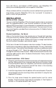
POWER The GlobalNav 310 will operate from a 12-volt DC system. (9 to 15 volts DC.) You can connect the power cable to an accessory buss under the dash, however, to keep electrical noise interference to a minimum, we recommend you wire the power cable directly to the battery through the supplied 2-amp fuse. CAUTION! Do not connect this product to a power source without using a fuse! Failure to use the fuse can cause damage to your unit and will void the warranty. Follow the wiring diagram below.
ANTENNA The GlobalNav 310’s antenna can be mounted on any flat surface, provided you have access behind the surface for the mounting screws. A magnet is also supplied that can be epoxied to the bottom of the antenna, allowing it to be used on off-road vehicles. A pole mount adapter lets you mount the antenna on a pole or swivel mount. ANTENNA INSTALLATION Surface Mount The antenna can be easily installed on any flat surface that is at least 90 mm (3 1/2”) wide.
After drilling the holes, pass the o-ring over the antenna cable and press it into the groove on the bottom of the antenna housing. Now attach the antenna to the mounting surface, using 4mm screws and the supplied lock washers. Route the cable to the GlobalNav 310 and the antenna installation is finished. Magnet Mount A magnet lets you temporarily mount the antenna on any ferrous metal surface.
KEYBOARD The keyboard has twelve keys. The arrow keys are tied to most of the features, letting you easily move the plotter’s cursor, navigate through the menus, make selections from menus, and other tasks. Z-IN MODE WPT ENT Z-OUT MENU EXIT PWR The WPT key lets you create, save, and recall waypoints and routes. The MODE key switches the unit between the three major displays: windows, navigation, and plotter. To select different features, or to modify functions, press the MENU key.
OPERATION Turning Power On To turn the GlobalNav 310 on, simply press the PWR key. A screen similar to the one at right appears. Read the message on the screen, then press the EXIT key to erase it. The GlobalNav 310 is now ready for use. MENUS Most of the Lowrance View’s adjustments and features are found on “menus”. Pressing the MENU key lets you view the menus. Different menus items are added to the basic list, depending on which mode (plotter, navigation, or windows) the unit is in.
Once it locks on to the satellites and finds your position, it stores the satellite data in its memory. The next time you use the unit, it should take much less time to lock on. To use your GlobalNav 310, first make certain you have a clear view of the sky, free from any obstructions such as trees, carport, or a covered boat dock. Press the PWR key. Read the message on the screen, then press the EXIT key to erase the message. A screen similar to the one at right appears. This is windows group “A”.
Using the down arrow key, highlight the “Initialize GPS Receiver” menu, then press the right arrow key. The screen shown below appears. This is the GPS initialization screen. The position, altitude, time, and date the GlobalNav 310 is currently using to find the satellites is shown at the bottom of this screen. Changing these values to your local position and time will speed the position lock. To change the position, press the right arrow key while the “EDIT LAT/LON” box is highlighted.
Now change the local time and date if they’re incorrect on this screen. (Don’t worry about altitude.) When everything is acceptable, press the EXIT key repeatedly to return to a mode screen. The GlobalNav 310 will instantly use the data you entered to find the satellites in the sky. (The unit knows which satellites will be available at the position, date, and time you entered.
NAV-1 PLOT-1 GROUP A as "GRP" (groups). For example, Group A is the first windows group on the MODE menu.) Press the right arrow key to see more screens on each mode. When the desired screen appears, press the EXIT key to clear the menu. Note: For a list of abbreviations used on the displays, see the back of this manual. Navigation Screens There are two navigation screens. Nav screen number one shows a graphical view of your trip, the other screen shows all navigation details in large digital numbers.
348°. The line extending behind the arrow in the center shows your track history, or path you’ve travelled. Your speed over ground or Ground Speed (GS) shows in the digital box to the right of the circle. The screen looks like this when you’re not navigating to a waypoint. (See page 35 for information on waypoint navigation.) If you navigate to a waypoint, the screen looks like the one below. The bearing to the destination waypoint is shown in the upper left corner of the screen.
Nav Screen #2 The navigation screen shows navigation information in large digital numbers. To view this screen, press the MODE key, then press the up arrow key until the black box surrounds the “NAV 1” label. Now press the right arrow key. A screen similar to the one at right appears. Press the EXIT key to erase the mode menu. This screen is composed of eight digital display boxes, showing your track (TRK), and ground speed (GS).
row key to move the black box to the "PLOT" label. Now press the right arrow or left arrow key to select plot 2. This screen (as shown at the bottom of the previous page) has navigation data displayed on the right side of the screen in digital numbers. This data is active whenever you’ve recalled a waypoint. Press the EXIT key to erase the mode menu. This screen shows ground speed (GS), track (TRK), course (CRS), and cross track error (XTK). Use the Z-IN and Z-OUT keys to enlarge or reduce the plotter area.
Record Trail On / Off The line extending from the present position diamond on the plotter is call the plot trail. As each dot on the trail is placed on the screen, it’s also saved in memory. The plot trail recording can be turned off, if desired. To turn it off, press the up or down arrow key until the “Record Trail” menu is highlighted and press the left arrow key. Press the EXIT key to return to the main menu.
In the track-up view at right, the present position moves straight towards the top of the display. As you can see, the anchor icon is now shown in its proper orientation - to our right. A "N" shows to help you see which direction is north when the track-up mode is on. Remember, in the track-up mode, the screen rotates as you change direction. It always keeps your direction of travel (track) heading towards the top of the screen.
Grid Lines The GlobalNav 310 can place grid lines on the plotter to help you see your position, or the position of waypoints and icons. To do this, highlight the “Grid Lines” label on the “Plotter Opts” menu, then press the right arrow key to turn them on. Press the EXIT key to exit this menu. A plotter screen similar to the one at right appears. The grid lines appear as vertical and horizontal dashed lines. ICONS The GlobalNav 310 has fifteen symbols or “icons” available.
press the ENT key. The plotter screen reappears with the icon at the cursor's location. Press the EXIT key to erase the cursor. On the screen shown at right, the large fish icon was selected and placed at the cursor location. Erase Icons To erase an icon from the screen, first press the MENU key, then select the “WPT/Icon Opts” menu. A screen similar to the one at right appears. There are three methods used to erase icons from the screen.
key to erase the icon. If you wish to delete another icon, move the cursor over it and press the ENT key. When you’re finished, press the EXIT key to erase the cursor. WINDOWS This feature gives you 15 different groups of windows so you can use the best navigation display for your situation. To use the windows feature, press the MODE key, then highlight the “GROUP A” label as shown below. Group “A” is visible in the background when you switch to the windows groups.
COURSE DEVIATION INDICATOR (CDI) The CDI shows your distance to the left or right of the desired course. You must recall a waypoint or run a route to use the CDI. The arrow in the center of the box shows the direction to the destination. For example, if you’re travelling straight towards the destination, the arrow points straight up. If you turn to the right, the arrow points to the left, showing that the destination is to your left.The smaller arrows pointing down on each side show the CDI’s range.
CLOCK Whenever a clock, timer, or alarm is showing on a display, new items appear in the list when you press the MENU key. These items let you set the clock’s time, alarms, or the timers. Clock Set If the time shown on the clock display is not your local time, change it using the “Clock Set” function. To do this, press the MENU key, then highlight the “Set Clock” label. Press the right arrow key. The screen at right appears.
Timers The GlobalNav 310 has two timers built in. One is a countdown timer and the other is a count-up timer. The countdown timer counts down from the time you put in to zero. The count-up timer starts at zero and counts up to the time you entered. To set either timer, first switch to a window group with a timer. Next, press the MENU key, then highlight the desired timer set menu. In this example, we’re setting the countdown timer. Now press the right arrow key. A screen similar to the one at right appears.
This is the plot-2 edit screen. The “BRG” box in the upper right corner flashes, which means it’s ready for change. If you don’t want to change this box, simply press the up or down arrow key to move to the box that you do want to change. In this example, we will change the BRG box to ground speed, or GS. To do this, simply press the left or right arrow key while the box is flashing. The box changes each time the arrow key is pressed.
Saving The Cursor Position as a Waypoint When the cursor is showing on the plotter and you press the WPT key twice, the GlobalNav 310 puts the cursor’s position into the first available waypoint number. A message appears on the display telling you the waypoint number it just used. Wait a few seconds and the menu will clear automatically or press the EXIT key to erase the waypoint menu.
Highlight the “Save Position As” label as shown below left and press the right arrow key when you’re at the location you wish to save. This saves your present position under the waypoint number you selected on the first page. Saving Cursor Position as a Waypoint (Select Number Method) To save the cursor position under a specific waypoint number, first position the cursor at the desired position.
WAYPOINT NAMES The GlobalNav 310 automatically assigns the waypoint number as a name when the waypoint position is saved.You can find a waypoint by highlighting the “Name” label on the waypoint menu as shown at right. Now press the right or left arrow keys to scroll through the saved waypoints. Only waypoints that have a position will show using this method. Edit Name The GlobalNav 310 also lets you assign a name to each waypoint. The name can have up to eight characters.
the up arrow key, then the right arrow key. This highlights the “TO” label, as shown at right. Press the down arrow key, then press the right arrow key until the desired waypoint number shows in the box. When everything on this page is correct, press the ENT key. Note:The names in the “From” and “To” boxes are not the waypoint numbers they are the waypoint names. When a waypoint is moved from one number to another, the new waypoint number gets the old waypoint name.
WAYPOINT OPTIONS You can customize the look of the waypoints on the plotter, or even turn them off. To do this, first press the MENU key, then highlight the “WPT/Icon Opts” label. Press the right arrow key. The screen shown at right appears. To keep the waypoints from showing on the plotter, simply press the right arrow key when the “Waypoints” label is highlighted as shown above. To change the method waypoints show on the plotter, highlight the “Display WPT” label. The default is numbers.
ROUTES You can connect several user waypoints together to form a route. When you recall the route, the GlobalNav 310 will show you navigation information to the first waypoint in the route, then when you reach that waypoint, it switches to the next waypoint, and so on until you reach the last waypoint in the route. To create a route, first press the MENU key, highlight the “ROUTES” label, and press the right arrow key. A new menu appears with the “Plan Route” label already highlighted.
This menu lets you go to the waypoint selection menu, delete a waypoint from the route, or see details about any waypoint in the route. Since we want to add a waypoint to the route, press the right arrow key on the “Insert From WPTS” label. The screen shown below appears. Select Waypoints Select the first waypoint either by using the waypoint name or waypoint number menus.
Finishing the Route When you’ve selected all of the waypoints for the route, simply press the EXIT key until you return to the navigation, plotter, or windows screen. Your route is saved in memory. Delete a Waypoint To delete a waypoint from a route, first select the route from the “Route Planning” or “Run Route” menus, then highlight the waypoint that you want to remove from the route’s list. Now press the right arrow key. The screen shown at right appears.
The black box is on the “Route # 1” label. If this isn’t the route you want to use, press the right or left arrow keys to switch to another one. Before starting the route, you’ll need to decide if you want to start at the beginning and travel forward or start at the last waypoint in the route and travel backwards (reverse) to the first waypoint. The default is forward. Next, highlight the “Start Route” label and press the right arrow key. The screen shown below appears.
Skip Waypoint The GlobalNav 310 lets you skip a waypoint in a route without stopping the route. To do this, first press the MENU key, then highlight the “Routes” menu and press the right arrow key, then highlight the “Skip WPT” label and press the right arrow key. The unit returns to the navigation, plotter, or windows screen with navigation data showing to the next waypoint on the list.
NAVIGATION Navigate To a Waypoint The GlobalNav 310 makes it easy to navigate to any waypoint. First, press the WPT key, then press the right or left arrow keys until the desired waypoint appears. Now highlight the “Go To WPT#” label and press the right arrow key. The unit immediately returns to the navigation, plotter, or windows screen and shows navigation information to the selected location. In this example, we recalled waypoint number 2.
Navigating to a Waypoint using the Plotter The unique “birds-eye” view used by the plotter gives you an easy way to navigate to a waypoint. On the screen shown at right, the diamond with a cross in it is your present position. The box with the “S” in it was your starting location when you recalled the waypoint. The dotted line is called a track line and is the shortest path from the starting location to the destination. The “D” is the cursor destination, the number with a box around it is the waypoint.
SYSTEM SETUP The GlobalNav 310 has several menus and commands listed under the “System Setup” label on the main menu. These commands affect the basic operation of the unit. To use them, press the MENU key, then highlight the “System Setup” label. Press the right arrow key. The screen shown at right appears. SPEAKER You can turn the speaker off. Turning the speaker off also turns off the audible portion of the alarms.
To change a unit of measure, first select the “Set Units” from the “System Setup” menu. The screen shown at right appears. Highlight the desired selection, then press the left or right arrow key.You can change one or all of the settings on this page. When you’re finished, press the EXIT key. Position Format To change the position format, highlight the “Position Format” label on the Units of Measure menu, (shown above) then press the right arrow key. A screen similar to the one at right appears.
The GlobalNav 310 can use the military grid reference system (MGRS). It uses two grid lettering schemes, which are referred to as standard and alternate MGRS on the GlobalNav 310. Your position and datum in use determines which one to use. In general, if the datum you’re using is valid for your present position, then use the standard MGRS, otherwise use the alternate MGRS. Press the up or down arrow keys to highlight the desired position format.
All wiring connections to the GlobalNav 310 are made to it’s power cable. See the sample wiring diagrams on the next page for general wiring procedures. Read your other product’s owner’s manual for more wiring information. Once the cables are wired, turn the GlobalNav 310 on, press the menu key, and select NMEA / DGPS from the System Setup menu. A screen similar to the one at right appears. NMEA OUTPUT To turn the NMEA output on, highlight the “NMEA OUTPUT” menu, then press the right arrow key.
GLOBALNAV 310 TRANSMITTING NMEA DATA TO ANOTHER DEVICE TO GLOBALNAV 310 GLOBALNAV 310’S WIRES WHITE WIRE RED WIRE TO +12V BLACK WIRE GROUND WIRES OTHER DEVICE’S WIRES OTHER DEVICE’S RECEIVE DATA WIRE 12 VDC BATTERY OTHER DEVICE TO GLOBALNAV 310 GLOBALNAV 310 RECEIVING DATA FROM A DGPS RECEIVER GLOBALNAV 310’S GREEN WIRE WIRES WHITE WIRE RED WIRE TO +12V BLACK WIRE GROUND WIRES DGPS RECEIVER’S TRANSMIT DATA WIRE DGPS RECEIVER’S RECEIVE DATA WIRE (IF NEEDED) 12 VDC BATTERY DGPS RECEIVER 41
DGPS receiver connected, the GlobalNav 310 can’t send NMEA data.) With the exception of serial communications, typically no other setup needs to be made with these receivers. If you have any other Magnavox or Starlink compatible DGPS receiver connected to the GlobalNav 310, you may need to change the settings. To do this, move the black box to the “Configure DGPS Beacon Receiver” label and press the right arrow key. A screen similar to the one at right appears.
If you restore the unit to the factory settings, all options such as contrast, alarms, and other system choices are returned to their default values. However, no waypoints, routes, or icons are erased. RESET GROUPS To return all groups to their factory defaults, highlight the “RESET GROUPS” label on the “System Setup” menu. Finally, press the right arrow key. All digital boxes on the navigation plotter screens are reset to their factory settings.
tializing the receiver. For example, if you entered east longitude instead of west. Or if you’ve moved a long distance with the unit turned off. To send a cold start message to the receiver, highlight the “Execute GPS Cold Start” label, then press the right arrow key. A message appears, asking you if you really want to do a cold start. Follow the instructions on this message page. The unit will begin searching for the satellites.
PCF (Position Correction Factor) Another method used to make your display match a chart or map is called “PCF” or Position Correction Factor. This unit gives you the capability to move or offset the position shown on the display to match one on the chart. The unit will add this offset to all position and navigation displays at all times. Remember, the position error on any radio navigation system is very dynamic and the PCF offset should never be used in an attempt to cancel the error.
After you’ve entered the latitude/longitude correction, press the ENT key to accept it. The GlobalNav 310 erases the PCF entry screen and returns to the navigation or mapping screens with the correction factor applied. POSITION PINING When using a GPS receiver at extremely low speeds, it can have trouble determining your course over ground, or direction you’re travelling. This is due in large part to SA, or selective availability.
the MENU key, then select the “ALARMS/CDI” menu. A screen similar to the one shown at right appears. Press the up or down arrow key to move the black box to the desired alarm, then press the right arrow key to turn it on. To adjust an alarm’s distance, move the black box to the alarm’s “DIST” menu item, then press the right or left arrow keys to increase or decrease the alarm’s distance. When you’re finished adjusting the alarms, press the EXIT key to erase this menu.
REPROGRAM WINDOW GROUPS You can customize the window groups to meet your own needs. The GlobalNav 310 gives you 35 different windows that can be rearranged into many combinations. To reprogram a group, first go to the modes menu and select the group that you wish to change. In this example, we’re reprogramming group “A”. Next, press the MENU key, highlight the "Reprogram Groups" label and press the right arrow key. A screen similar to the one shown at right appears.
RESET GROUPS To restore all windows groups to their factory settings, first press the MENU key, then highlight the “System Setup” label and press the right arrow key. Now highlight the “Reset Groups” label on this menu. Press the right arrow key. A message appears, asking if you really want to do this. Press the right arrow key to continue, or the left arrow key to exit without resetting the groups.
SIMULATOR A simulator is built into the GlobalNav 310 that has several options. You can use nearly all of the unit’s features - even save and recall waypoints. This is useful for trip planning. To use the simulator, press the MENU key, then press the up or down arrow keys until the “Simulator Setup” menu is surrounded by the black box. Now press the right arrow key. The screen shown at right appears.
keys to increase or decrease the speed. Use the right and left arrow keys to change the track. Press the EXIT key to erase these menus. When you’re finished changing the track and speed, press the EXIT key to erase the menus. To turn the simulator off, press the MENU key, then move the black box to the “Simulator Setup” label. Finally, press the left arrow key. Note: Your plot trail will be erased when you turn the simulator on or off.
WINDOWS The following is a listing of windows groups A through O.
GROUP “I” GROUP “J” GROUP “K” GROUP “L” GROUP “M” GROUP “N” GROUP “O” 53
Lowrance's UPS Return Service - U.S.A. Only Lowrance Electronics and United Parcel Service (UPS) are proud to offer all of our customers free shipping for all units sent to us for repair or service. If you have to send this unit to the factory, and you are in the continental United States, use the enclosed UPS shipping label for easy, free shipping to our factory customer service department. There are six easy steps: 1.
KEEP THIS LABEL! YOU WILL NEED IT IF YOU EVER NEED TO RETURN YOUR UNIT TO THE FACTORY FOR REPAIR. Accessory Ordering Information To order accessories such as power cables, please contact: 1) Your local marine dealer. Most quality dealers that handle marine electronic equipment should be able to assist you with these items. Consult your local telephone directory for listings. 2) LEI Extras, Inc. P.O. Box 129 Catoosa, OK 74015-0129 or call 800-324-0045 (USA orders only.
LOWRANCE ELECTRONICS FULL ONE-YEAR WARRANTY “We", “our”, or “us” refers to LOWRANCE ELECTRONICS,INC., the manufacturer of this product. “You” or “your” refers to the first person who purchases this product as a consumer item for personal, family, or household use. We warrant this product against defects or malfunctions in materials and workmanship, and against failure to conform to this product’s written specifications, all for one year (1) from the date of original purchase by you.
THIS PAGE INTENTIONALLY LEFT BLANK 57
4.
How to Obtain Service (Canadian Customers Only) We back your investment in quality products with quick, expert service and genuine Lowrance replacement parts. If you need service or repairs, contact the Lowrance Factory Customer Service Department at the toll-free number listed below. A technician may be able to solve the problem and save you the inconvenience of returning your unit. You will be asked for your unit's serial number. 800-324-1354 Canada Only. Monday through Friday 8:00 A.M. - 8:00 P.M.
How to Obtain Service - U.S.A. Only We back your investment in quality products with quick, expert service and genuine Lowrance® replacement parts. If you're in the United States and you have questions, please contact the Factory Customer Service Department using our toll-free number listed below. You must send the unit to the factory for warranty service or repair. Please call the factory before sending the unit. You will be asked for your unit's serial number.
63