
Operation Manual

LX90xx system Version 4.0 February 2014
Page 122 of 151
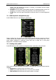
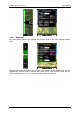
Orientation symbol is showing direction of north.
Final glide symbol shows current MacCready setting and information about required
altitude. It is highly recommended to include this symbol on navigational page.
Battery displays status of power supply.
GPS Status indicates status of gps signal.
Wind Arrow shows direction of wind relative to map orientation
Zoom symbol defines scale of map.
Side View enables lateral view of our position toward selected goal.
Picture symbol will print images binded to selected waypoint or airport.
Flarm Radar symbol will display a radar screen showing Flarm targets at predefined
zoom, which can not be modified.
Artificial Horizon will show an artificial horizon symbol.
Altitude Tape shows altitude with some additional features like on modern primary
flight displays.
Airspeed Tape shows airspeed with some additional features like on modern
primary flight displays.
Magnetic Rose and Magenetic Rose2 displays magnetic rose around aircraft.
Flaps tape
®
is unique display of current and required position of flaps. Scale of flap
tape matches airspeed tape.
3D map enables display of synthetic 3D terrain. This option is not available in
version 4.0 of firmware.
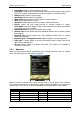
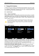
7.2.1 Navboxes
Navbox is basic element used on navigational page to display numerical value for selected
value. Press EDIT button to edit navbox properties
Navbox consist of numerical value, which can have units or can be without units, and title.
Title can be customized only for all navboxes together through GLOBALS style. However title
can be hidden. There is a lot of navboxes available. See following table for more details.
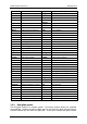
Title
Description
Title
Description
60'.Sp
Last 60 minutes speed
ReqAlt
Required altitude to target
Agl
Height above ground
reqE
Required glide ratio to target
Alt
Altitude above MSL
reqFlaps
Requested Flaps
AltGain
Gained altitude in thermal
reqSTF
STF for required MacCready
AltIGC
IGC altitude
Rwy.Dir
Target runway direction