
Operation Manual


LX90xx system Version 4.0 February 2014
Page 43 of 151
6.1.5.7 Managing Maps
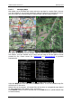
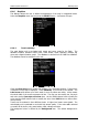
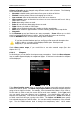
Main display unit is preloaded with terrain and vector map data for complete Earth. However
it is also possible to use scanned (rasterized) maps as background of navigational screen.
Next two images are showing example of scanned ICAO map and satellite imagery.
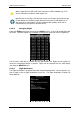
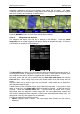
The system is supporting two file formats: CMR file format provided by SeeYou software
from Naviter. There are available free of charge sectional maps of USA and QMP file format
provided by Ifos. Please contact Ifos (www.ifos.de) or (www.strepla.de) to purchase
scanned maps.
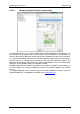
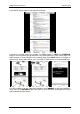
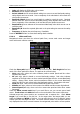
Select the Maps menu item and press the SELECT button. A list of all available map files
will be shown on the screen.
Multiple files can be selected. All checked files will be shown on navigational page depend
on raster map setting (See chapter 6.1.6.1 and 6.5.6.3).
Press DELETE button to remove selected map. Press LOAD button to upload selected map
to internal memory.