
Operation Manual


LX90xx system Version 4.0 February 2014
Page 47 of 151
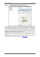
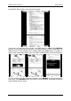
6.1.6 Graphics
This dialogue allows the user to define the appearance of the map in navigational mode.
Select the Graphics menu item and press the SELECT button. A submenu will open.
6.1.6.1 Terrain and Map
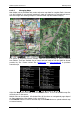
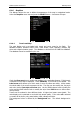
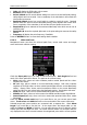
The main display unit is pre-loaded with terrain and vector maps for the Earth. The
database includes: elevation contour lines, water bodies, roads, highways, railways, big
cities and a digital elevation model. The database is derived from the OSM free database.
The database cannot be modified by the user.
Check the Show map item to enable map displays in the navigational pages. If this item is
unchecked no map will be displayed. Check Shadows, if you terrain to be shaded. The
Label zoom value defines up to which scale of zoom city names are visible. 100km means
the whole width of the screen represents 100 km. The user can also modify size, font style
and colour via the Font style and colour item. Use the ZOOM selector knob to modify the
colour and the PAGE selector knob to modify the style. Press PICK button to define colour
more precisely.
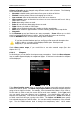
Terrain can be rendered in three different levels. A higher level means more details. The
main display unit is optimised to work with high terrain quality. If the value off is selected
no terrain will be shown; only water bodies, roads, railways and cities.
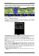
The background colour is defined by the Background item. The default background is
black.