
Operation Manual


LX90xx system Version 4.0 February 2014
Page 48 of 151
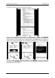
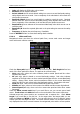
Colours of terrain can be changed using different terrain colour schemes. The following
colour schemes are available:
Mountain is default setting with colours from green to white at 2000 m.
Flatland is setting where colours are changing up to 1000 m.
Low contrast: same as Mountain but colours are not so intensive.
High contrast: same as Mountain but colours are more intensive and from 0-100 m,
white colour is used.
Zebra alternating colours are used.
Zebra 2, less intensive alternating colours are used.
ICAO colouring is similar to ICAO maps.
Cliffs colours emphasis slopes and is similar to Google maps display
Atlas colour scheme is approximation of Imhof colouring widely used in map books.
Grayscale.
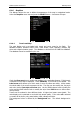
In the Elements group land features are setup separately. Zoom defines up to which
zoom level a selected land feature is visible. Also line width and colour can be setup.
Press the DEFAULT button to reset these settings back to default.
If you have checked shadows and you are flying on flat areas with elevation close
to MSL or below, on terrain will be displayed black spots. Black spots will
disappear, if you uncheck shadows.
Check Show raster maps, if you would like to see also scanned maps (See also
chapter 6.1.5.7).
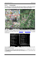
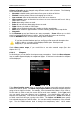
6.1.6.2 Airspace
In this dialogue you can define the airspace map presentation. Check the Show airspace
item to enable airspace displays in navigational pages. If this item is unchecked no airspace
will be displayed.
If the Show inactive zones option is checked then airspace zones with proximity warning
switched off will be shown. Use Show only airspace below to eliminate airspace which is
going to be too high for the day. For example, if the forecasted cloud base is to be 1500 m,
set this value to 1600 m and your screen will be much more readable. In the Type panel
you can specify how each airspace type is displayed. You should define each type of
airspace zone separately. First choose an airspace type from the list. Zoom value defines
to which zoom level this type is going to be visible. The Colour and Width items specify
how selected airspace zone will be drawn. You can also modify transparency of the selected
type. Turn the ZOOM selector knob to change the transparency value. 100% means