
Operation Manual


LX90xx system Version 4.0 February 2014
Page 50 of 151
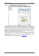
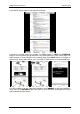
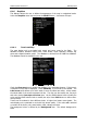
Code: will display the ICAO code or short name.
Elevation: shows waypoint elevation.
Arrival altitude shows arrival altitude taking into account current MacCready setting,
safety altitude and current wind. Due to complexity of the calculation it will not take the
wind profile into account.
Required altitude shows how much height is needed to reach the point. Required
altitude takes into account current MacCready setting, safety altitude and current wind.
Due to complexity of the calculation it will not take the wind profile into account.
Required Mc gives an estimate of the maximum MacCready value which we can use to
reach the point.
Required L/D shows the required glide ratio to the point taking into account the safety
altitude.
Frequency will display the point frequency, if available.
Press the DEFAULT button to reset these settings back to default.
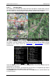
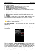
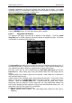
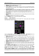
6.1.6.4 Glider and Track
Navigational screen can show the coloured path flown, current track vector and target
vector with terrain collision warning.
Check the Show path item if you want to see the flown path. Path length defines how
much of the flown path will be shown. The path can be coloured using:
Vario path style, where red colour indicates positive vertical speed and blue colour
negative vario values.
Mc path style, which is based on current MacCready settings. Red colour indicates
segments of the flight where we have vertical speed higher than the current MacCready
setting. Orange colour shows vertical movements similar to the current MacCready
setting and blue for vario values below the MacCready setting. Grey depicts sink areas.
Fixed path style. Path colour is fixed and defined by path colour item.
Altitude path style, where red colour means low altitude and blue means high altitude.
Ground speed path style, where red colour means slow speed and blue colour means
fast speed.
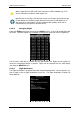
Check the Show current track item if you would like to see your current ground track
vector. Track colour and width defines the colour and width of the current track vector.
Selected target and current position are connected with a magenta line. Check Show
target if you would like to see this line. In the target colour and target width you can
select the Colour and Width of this line. You can also choose to show or hide the terrain
collision point and the target line itself. The terrain collision marker is a red square which is
only displayed when there is terrain between the navigational point and the current position