
Operation Manual

LX90xx system Version 4.0 February 2014
Page 81 of 151
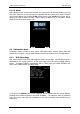
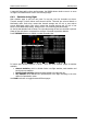
6.1.18 About
About dialogs shown current serial number end version info od the main display unit. Use
this menu, whenever you are experienced a problem with the system. If SD card is inserted
into the main display unit, button TO SD will be shown. Press TO SD and a report will be
saved to SD card. A report will have a name »debug_20140216_14_21_28.reprot«. Please
email this report to us for further help.
6.2 Information Mode
Information mode consists of three pages; GPS status page, position report page and
satellite sky view page. Use the PAGE selector knob or the up/down arrow to toggle pages.
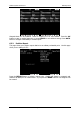
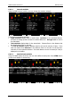
6.2.1 GPS Status Page
GPS status, altitude, flight level and height are shown on this page. Sunrise and sunset are
calculated for the current position. In the upper-right corner the current FLARM status is
shown. TX means FLARM is transmitting data to others and the number indicates how
many other FLARM devices are within range.
If you press the MARK button a new waypoint will be created with the current latitude,
longitude and elevation based on the terrain database. The waypoint name is generated
from the current date and time separated by the minus character and preceded by an
underscore.