
Operation Manual

LX90xx system Version 4.0 February 2014
Page 83 of 151
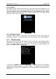
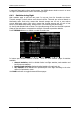
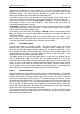
6.2.3 Satellite Sky View
Information about tracked satellites is given on this page. If no satellite information is
available a message
“No satellite info”
is displayed.
Green satellites are satellites currently being used for position determination. Three
concentric circles represent satellite elevation (0, 30, 60 degrees above horizon). If a
satellite is in the centre of the circles it is directly overhead.
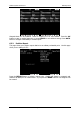
When you are experiencing bad satellite reception, check this page. If the satellites are
always red in a particular place, you should consider moving the GPS antenna to another
position. If you press the MARK button a new waypoint will be created.
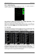
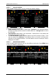
6.3 Near Mode
A list of all landable waypoints and airports is shown in this mode. The default sorting order
of the items is by arrival altitude. Press the SORT button to toggle the sort method. The
selected sort method is indicated by the grey background in the header.
Press VIEW button to change how much details are visible for selected item. Select the
preferred landable place via the PAGE selector knob and press the GOTO button. It will
automatically change to airport mode and navigation will commence to selected point.
Duplicates are automatically removed. If a target with nearly the same latitude and
longitude is found within both the distributed airports database and user waypoint file then
only the target from the user waypoint file will be displayed.