
Owner's Manual
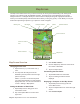

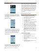


Magellan eXplorist Dashboard
Magellan eXplorist 510 / 610 / 710 User Manual 12
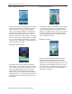
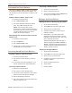
Barometer Screen
The Barometer Screen (not available on the eXplorist
510) uses the internal sensor in the eXplorist 610 or
710 to graphically display the recorded barometric
pressure. The graphic can be zoomed in on, moved,
as well as the green line moved along the graphic
providing detailed barometric information about the
point on the graph selected.
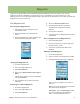
Altimeter Screen
The Altimeter Screen displays detailed elevation
information using the GPS signal or the built-in
altimeter sensors (eXplorist 610/710). The area on
the graph can be expanded by tapping the icon in the
lower right corner and dening the area to be used.
Also a line can be moved along the graph to pinpoint
an exact point on the graph and display detailed
information on that point.
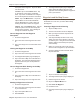
Strip Compass Screen
The Strip Compass screen displays a strip compass
(similar to the Road screen but the Strip Compass
screen provides more room for additional data
elds). This compass displays your heading and
your heading’s relation to the sun, moon and your
destination (black arrow) when they are within 50
degrees on either side of your heading. The orange
arrows under the strip compass will show which way
to turn to head towards your destination. The data
elds at the top of the display are customizable (see
Customizing the Data Fields).
Satellite Status Screen
The Satellite Status screen displays a graphical
representation of the satellites overhead in relation
to you current location (the center of the circle) The
color of the satellite graphics, as well as the bar
graph, indicate the signal strength of the signals
being received. The numbers indicate the assigned
satellite designation. The data elds at the bottom of
the display are customizable (see Customizing the
Data Fields).