
User manual


How
Do
I
Read
the
Map
screen?
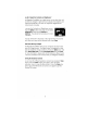
The Map screen
is
used most often when traveling and provid'es you
with information about where you are and where you are going.
POI
Icon
t
---
Next
Maneuver
Direction
of
Travel
and
GPS
Signal
Strength
tt
Distance
to
Next
Maneuver
Position
Cursor
(points
in
the
""".:::::iiiiiiiMII
........
~--direction
you
are
traveling)
ID-§-~-Next
Road
Distance
to
Destination
Direction
of
Destination
t
By
touching
the
POI
icon
on
the
screen,
you
can
get
information
and
route
to
it.
tt
Blue
=
WASS
Signal,
Green
=
Strong
Signal,
Yellow
=
Average
Signal,
Red
=
Weak
Signal,
Black
=
No
Signal
As
you travel, the Guidance screen constantly updates your location
and provides you with not only a map, but also a visual indication of
where you are on the map.
Changing
the
Map
Zoom
Levels
You
can increase or decrease the detail of the Map screen by
pressing the
Zoom
In
(+) or
Zoom
Out
(-)
button (see page 2).
How
Can
I
See
the
Entire
Route?
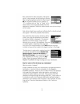
The Maneuver List screen can
be
viewed only
after a route has been calculated. From the Map
screen, press the
View
button to bring up a list of
all of the maneuvers along the route. When you
are done viewing the Maneuver List screen,
press the
View
button twice to retu
rn
to the
Ma
p
screen, or wait a few moments and it will return automatically.
How
Can
I
See
What
the
Next
Maneuver
Will
Be?
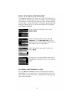
The Magellan RoadMate uses TrueView
3D
technology to display a three-dimensional
picture of the next maneuver. The TrueView 3D
screen can
be
viewed only after a route has been
calculated. From the Map screen, press the
View
6