
Manual
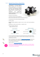


50
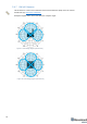
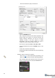
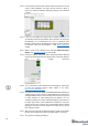
4.1.10 If the map does not form well, check the table of distances in the left
corner of the Dashboard. The cells must be colored in white; it
means the distances between stationary beacons are measured
correctly
4.1.11 If you see in the table some empty cells or marked yellow/red, it is
an indication that distances between Some beacons are measured
inconsistently or not measured at all. Try to re-position them
because usually there is an obstruction of some sort in the between
the beacons. If you have any problems – check Table of distances
chapter
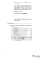
4.1.12 Make a service zone, clicking on the map with Shift+Left Mouse
Button. See Submaps chapter for more details
4.1.13 Freeze the map by clicking the button. Stationary beacons will stop
measuring relative distances and will be ready to measure distance
from the mobile beacon(s)
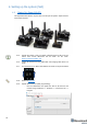
4.1.14 Turn on and wake up the mobile beacon following the same steps
as with the stationary beacon. More details in our video:
https://youtu.be/A4aRsjH2-_E
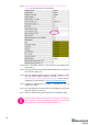
4.1.15 If you see on the devices’ panel in the Dashboard that the beacon is
colored orange, it means there are some differences in some of the
settings between beacons. For example, some sensors may be off
or some ultrasonic or radio settings may be different. You can
change the settings for sensors manually by clicking on the panel on
the upper right corner of the Dashboard to change the cells from
gray to green to turn on sensor. It is recommended that the default
settings on all beacons and the modem are used if this is your first
time using the system.
4.1.16 After you freeze the map of stationary beacons, wake up the mobile
beacon. After it wakes up, it will be traceable within 5-7 seconds.
4.1.17 The system is now fully operational.