
Owners Manual

:
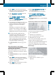
Hills
;
Buildings
=
Important buildings
Showing the map data version
X
To show the menu: press W the COMAND
controller.
X
Select Navi in the main function bar by
sliding ZV and turning cVd the COMAND
controller and press W to confirm.
X
Select Map Version and press W to
confirm.
The map data version number is shown.
Information about new versions of the
digital map can be obtained from an
authorized Mercedes-Benz Center.
Traffic information on the map
If you subscribe to the SIRIUS XM Satellite
Radio Traffic Message Service, traffic
information can be displayed on the map. You
can select three categories for the display.
X
To switch the displays on/off: press W
the COMAND controller to show the menu.
X
Select Navi in the main function bar by
sliding ZV and turning cVd the COMAND
controller and press W to confirm.
X
Select Traffic Information On Map and
press W to confirm.
X
Select a category and press W to confirm.
Depending on the previous state, switch
the option on O or off ª.
R
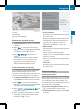
Traffic incidents
Road sections are illustrated with a yellow
line and arrows.
Warning messages or traffic incidents are
represented on the map by appropriate
symbols and/or yellow/red arrows.
Explanation of symbols (Y page 179).
R
Speed & Flow
Road sections are represented by yellow or
red car icons.
Green arrows: free-flowing traffic
Yellow car icons: congested traffic, average
speed 25 - 45 mph
Red car icons: traffic jam, average speed 5
– 20 mph
R
Free Flow
Road sections are illustrated with a green
line and arrows.
Additional settings
Freeway information
When driving on highways, you can have the
nearest gas stations, rest areas, etc. shown
on the right-hand side of the display. Your
current distance to them is also shown on the
right-hand side of the display.
X
To activate navigation mode: press the
S function button once or twice.
X
To show the menu: press W the COMAND
controller.
Navigation
191
COMAND
Z