
Marine Instruments User Manual

mn100 Dual Digital Display
24
Options Chapter
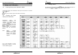
(s30) AUTO NETWK
Only available on the instrument which was used to power
up the system. Refer to the “Auto Network” sheet for further
information.
(s31) CHAP PROG (lower window)
Allows one further selection to be added to the Chapter list
(see page 9). The current selection is indicated in the
Chapter window.
(s32) TIME
The number of hours added or subtracted from UTC (GMT) to
allow the instrument to display local time.
(s33) LIGHT
Tells the instrument to control the system Backlighting or
just its own Backlighting. Network/Local.
(s34) bOAt SHOW
Allows the instrument to display information when NOT
installed as part of a Micronet system for demonstration
purposes only. On/Off. This setting will reset to Off when the
instrument is switched off.
(s35) DISPL CONTR
Allows the contrast of the LCD display to be adjusted to suit
the viewing angle of the instrument. The lower the figure the
less contrast is visible. 1 - 7 default 4.
(s36) RESET
Returns all the calibration setting to the factory default
values but does not reset your Auto Networking.
Only carry out a Reset after consulting with an
authorized Tacktick dealer.
Operation
13
2. If you do not have a Wind Transmitter included, sail close
hauled and press the
button then tack and, once close
hauled, press the button again.
If the mean wind direction changes then the instrument may
be updated by press and holding the
button while
sailing on port tack, the
button while sailing on
starboard tack or the
button while head to wind.
See Tacktick’s “Using wind shifts to your advantage” sheet
for further information.
(p18) MAG HDG
Current Magnetic Compass Heading of the vessel as
measured by the Compass Transducer. The value displayed
will be affected by the calibration routine for the compass
(see page 26).
(p19) MAG TACK
Magnetic Compass heading which the vessel will follow
should it tack through the wind, calculated by the
instrument. Apparent Wind Angle and Magnetic Heading
must be available on the network for this calculation to be
made.
(p20) SOG
Vessels Speed Over the Ground as calculated by the GPS
Antenna.
(p21) COG
Vessels Course Over the Ground as calculated by the GPS
Antenna.
(p22) LAT
Vessels current Latitude as calculated by the GPS Antenna.
(p23) LON
Vessels current Longitude as calculated by the GPS Antenna.
(p24) BTW
Bearing To (active) Waypoint. The active Waypoint being the
one to which the GPS is currently navigating.