S-Series Smart 2009 Software User Manual en English - United Kingdom SPIRIT
Important safety information PLEASE READ CAREFULLY BEFORE INSTALLING PRODUCT IN VEHICLE This is the safety alert symbol. It is used to alert you to potential personal injury hazards. Obey all safety messages that follow this symbol to avoid possible injury or death. WARNING indicates a potentially hazardous situation which, if not avoided, could result in death or serious injury. CAUTION indicates a potentially hazardous situation which, if not avoided, may result in minor or moderate injury.
Contents Important safety information...................................................................................................................2 Welcome................................................................................................................................................5 Important information for using the manual .......................................................................................5 Formatting ..............................................................
How do I view my call history? ........................................................................................................44 How do I play media? ..........................................................................................................................45 Playing audio files ...........................................................................................................................45 How do I listen to a music file on my Navman?.....................................
Welcome This manual has been prepared to guide you through the operation of your Navman from first set-up through to continuous use. Please read this manual carefully before using your Navman for the first time. Keep this manual in a safe place and use as your first point of reference. Important information for using the manual It is important to understand the terms and typographical conventions used in this manual.
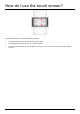
How do I use the touch screen? Your Navman touch screen options change dynamically: To see all options on a menu, drag the screen up or down. To display the next screen, tap an icon or select an option. To dock a menu to the left, tap the left edge of the menu. To dock a menu to the right, tap the right edge of the menu.
How do I get started? The first time you use your Navman, it may take up several minutes to establish a GPS connection. For more information about GPS, refer to the GPS Frequently Asked Questions guide on the enclosed DVD. How do I turn my Navman on for the first time? To get started for the first time, complete the following steps: 1. Read the Important Safety Information on page 2. 2. Position your Navman in your vehicle. Follow the instructions in the Hardware User Manual.
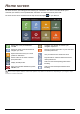
Home screen The Home screen is your starting point for searching for a destination. The Home screen also allows you to customize your Navman, receive updated traffic information and make and receive phone calls. The Home screen can be accessed from the map screens by tapping on your Navman. Easiest way to set your destination and GO! Configure your Navman to enhance your navigation experience. Search for places, areas and streets to help plan your route.
How do I go from A to B? Your Navman is equipped with maps that provide street-level detail for door-to-door navigation, including Points of Interest such as accommodation, parking areas, petrol stations, railway stations and airports. When you ... Then ... know the address of your destination use the GO address wizard to enter the address. See "How do I plan my first trip?" on page 11. need to search for an address use the FIND address wizard to search for the address.
Using the Keyboard screen The Keyboard screen will display when you are required to enter text, such as when searching for a street name. Search results will be listed in matching order, with the closest matches appearing on the screen. A maximum of 99 results will display. The Keyboard screen can display with various layouts depending on the information you need to enter, including alphabet, number, alternate characters and combinations of these. To select a character, tap the character.
How do I plan my first trip? Using your Navman to plan your first trip is easy. There are several ways to select your destination. Complete the following to navigate to a street address that you know using the GO address wizard. Your Navman will calculate the route from your current location. The Map screen will display.
How do I view my route? When a route has been calculated, the Map screen will display. You will be directed to your destination by spoken and visual instructions. Item Description Direction and distance of next turn The direction and distance to your next turn Add waypoint to trip Tap to repeat the vocal instruction. Adds a location as a waypoint on your trip. Tap to remove the waypoint from your trip. Next turn and current route Your next turn and current route are highlighted.
How do I search for an address using the FIND address wizard? The below address is fictitious and used as an example only.
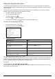
Complete the following: If you want to ... Then ... calculate the route, open the Map screen and start navigating tap GO. The Map screen will display. save the location as Home tap Add to My Places. The Save screen will display. tap Save as Home. save the location as a favourite navigate to a place near the location explore the area near the location tap Add to My Places. The Save screen will display. tap Save as My Place. tap Pick on Map. The Pick on Map screen will display.
How do I search for a Point of Interest (POI)? A POI is a named site, feature, landmark or public venue which can be displayed as an icon on the map. POIs are grouped by category, such as petrol stations, parks, beaches and museums. Buckingham Palace London, England Complete the following: If you want to ... Then ... calculate the route, open the Map screen and start navigating tap GO. The Map screen will display. save the location as Home tap Add to My Places. The Save screen will display.
How do I set my route preferences? You can enhance your navigation experience by modifying aspects of your route and route calculations. 3. From the GO screen, tap Other options. The Other options screen will display. 4. Complete the following: If you want to... Then... set route type options for your route tap Route type. The Route type screen will display.
How do I use the Explore map? The Explore map allows you to explore the local area to find Points of Interest (POIs) or navigate to an address. If you do not have a GPS fix, the map will display your last known position. Tap and drag the map to explore the local area. Tap the map to display a POI Cluster showing POIs in the surrounding area. Tap a POI icon to show more information and navigate to the POI. Item Description Angle options Tap to adjust the horizontal viewing angle.
How do I explore an area for a POI? An amusement park near London Eye, London.
Complete the following: If you want to ... Then ... calculate the route, open the Map screen and start navigating tap GO. The Map screen will display. save the location as Home tap Add to My Places. The Save screen will display. tap Save as Home. tap Add to My Places. The Save screen will display. tap Save as My Place. place a phone call to the POI tap Call. navigate to a place near the location save the location as a favourite This feature is not available on all models.
How do I explore a map for a POI? If you want to ... Then ... calculate the route, open the Map screen and start navigating tap GO. The Map screen will display. save the location as Home tap Add to My Places. The Save screen will display. tap Save as Home. tap Add to My Places. The Save screen will display. tap Save as My Place. place a phone call to the POI tap Call.
How do I set my POI preferences? Points of Interest (POIs) are grouped into categories. You may choose to either display (or hide) icons of all POI categories on the map screens, or only display the icons from selected categories. For example, you may only be interested in entertainment venues and want to disable other categories such as schools. 1. From the EXPLORE screen, tap Places settings. The Places settings screen will display. 2. Complete the following: If you want to... Then...
How do I preview a route? Route simulation allows you to: Preview a route. Plan and view a route without a GPS fix, for example when you are inside a building. The following steps will show you how to preview a route: 1. Select a departure point. If you have a GPS fix, you do not need to select a departure point unless you want the demonstrated route to start elsewhere. a) b) Tap From. The Leaving from… screen will display. c) Tap Find a place, then follow the example steps on page 10. 2.
How do I view my route statistics? Your Navman provides information on your: distance to go estimated time of arrival distance travelled average speed maximum speed time taken for trip stationary time. To view your route statistics during a planned route: 1. Tap and then tap The GO screen will display. 2. Tap . The Route Statistics screen will display.
How do I navigate to a recent place? To make navigating to an address easier, your Navman will automatically save all your start locations and destinations in a list of recent places. 1. Tap Recent places. The Preview screen will display. 2. Tap a recent place. The Preview screen will display. 3. Complete one of the following: If you want to ... Then ... calculate the route, open the Map screen and start navigating tap GO. The Map screen will display.
If you want to ... Then ... explore the area near the location tap Explore this area. The Explore Map will display. tap the docked menu to see the menu options. The Explore screen will display.
My Places My Places has all your saved and captured locations. It also contains POIs, NavPix and albums you have downloaded onto your Navman via NavDesk. How do I save a location as My Place or Home? Search for an address until the Preview screen is displayed. 1. Tap Add to My Places. The Save screen will display. 2. Tap Save as My Place. The Preview screen will display. 3. To change the name of the favourite, tap the name of the favourite. The Keyboard screen will display. 4.
How do I navigate to a location I have saved? 1. Tap the Favourite destination you want to travel to. The Preview screen will display. 2. Tap Go. Your Navman will calculate the route from your current location. The Map screen will display. How do I navigate to Home? If you have not set an address as Home, the first time you try to navigate to Home you will be prompted to search for an address using the address-entry wizard. 1. From the My Places screen, tap Home. The Preview screen will display. 2.
How do I edit the name of a location in My Places? 1. From the My Places screen, select a favourite to edit. The Preview screen will display. 2. Tap on the favourite name. The Keyboard screen will display. 3. After you have edited the name, tap OK. The Preview screen will display. How do I delete a Favourite? 1. From the My Places screen, select a favourite to delete. The Preview screen will display. 2. Tap Delete. The favourite is deleted. The My Places screen will display.
How can I view a POI I have downloaded using NavDesk? 1. Tap the POI you want to travel to. The Preview screen will display. 2. Complete one of the following: If you want to ... Then ... calculate the route, open the Map screen and start navigating tap GO. The Map screen will display. make a phone call to the POI tap Call. navigate to a place near the location This feature is not available on all models. explore the area near the location tap Pick on Map.
How do I navigate to a NavPix? Pictures that contain GPS co-ordinates are called NavPix and can be used to navigate to the GPS location. To navigate to a NavPix location, either a GPS fix must have been available when the NavPix was taken, or GPS co-ordinates have been added using NavDesk. 1. From the My Places screen, tap the NavPix you want to navigate to. The Preview screen will display. 2. Complete one of the following: If you want to ... Then ...
How do I navigate to a NavPix in an album? The albums contain all your photos and displays them as thumbnails. Element Description Displays the previous screen Slide Show Displays all images in the album as a full-screen slideshow. Album title The title of the album. NavPix thumbnail A thumbnail of a NavPix contained in the album. To select a NavPix, tap the thumbnail. The NavPix Details screen will display. Indicates that the picture is a NavPix, with embedded GPS co-ordinates.
NavPix management The NavPix Details screen displays information about your NavPix. Tap a NavPix to display the Photo Details screen. Element Description NavPix Title and address The title of the NavPix and its address. GO Your route will be calculated and displayed on the Map screen. This button is only available if the NavPix contains GPS co-ordinates. Add to My Places Allows you to save the NavPix in My Places. NavPix information Displays information about the NavPix.
How do I view a NavPix in full-screen? 1. From the NavPix Details screen, tap the thumbnail of the NavPix. The NavPix will appear in full-screen. OR From the Album detail screen, tap Slide Show. The NavPix will appear in full-screen 2. The icons disappear after a few seconds; tap the screen to have them reappear. 3. Complete the following: If you want to ... zoom into the NavPix zoom out of the NavPix rotate the NavPix Then ... tap . tap . .
How do I save a NavPix under My Places? You cannot save a NavPix as a favourite if GPS co-ordinates are not available. 1. From the Album screen, tap a NavPix. The NavPix Details screen will display. 2. Tap Add to My Places. The Save screen will display. 3. Complete the following: If you want to ... Then ... save the NavPix as a Favourite (when GPS co-ordinates are associated with a picture) tap Save as My Place. The NavPix is saved and the Photo Details screen will display.
How do I capture the GPS co-ordinates of my location? Your Navman has a capture feature which allows you to record GPS co-ordinates of a location and save them so you can navigate back at a later time. 1. on your Navman. Press You will hear a shutter sound to indicate that the GPS co-ordinates have been saved. The location is saved under My Places. How do I navigate to a location I have captured? 1. From the My Places screen, tap the location you have saved. The Preview screen will display. 2.
What is Connect (Local Search)? Connect is not available on all models. Connect allows you to search online for live POI information. Using Connect you can search for and navigate to POIs using your Navman or you can navigate to POIs you have downloaded using NavDesk. To search for POIs using your Navman, you must pair your Navman with your mobile phone. If your Navman isn’t paired with your mobile phone, the Bluetooth screen will display.
2. Tap and select your preferred search service. The Keyboard screen will display. 3. Use the Keyboard screen to search for a POI, then tap OK. The List of Results screen will display. 4. Select a POI. The Preview screen will display.
5. Complete one of the following: If you want to... Then... calculate the route and open the Map screen tap GO. Your route is calculated; the Map screen will display. place a phone call to the POI tap Call. navigate to a place near the location tap Pick on Map. The Pick on Map screen will display. tap an area and tap OK. The Preview screen will display. explore the area near the location save the destination as a Favourite change your destination tap Explore nearby.
How do I make a hands-free Call? Hands-free calling is not available on all models. If you have a mobile phone with Bluetooth wireless technology, you can use your Navman as a hands-free car kit or to provide an internet connection. It can also be used to connect to a Bluetooth mono/ stereo earphone to output audio. Models with Bluetooth capabilities can exchange information over a distance of about 10 metres (30 feet) without requiring a physical connection.
Configuring internet settings The Internet connection when turned on allows you to access live information over the internet. Your mobile phone service provider’s default settings will be displayed. When internet settings are not available, a warning message will be displayed. To enter internet settings: Tap any fields to access the keyboard screen to edit the internet configuration. When you enter your password the characters are replaced with * to protect your pass code information.
How do I make a phone call? 1. From the Phone screen tap Dial. The Dial screen will display. 2. Enter the number you want to call. The number of the last call will display when you next access the Dial screen. The number will be cleared as you start entering a new number. 3. To delete the last digit entered, tap To clear the entire number, tap and hold . . International calls require a country code to be included in the phone number.
How do I receive a phone call? When you receive a call, the Incoming call screen will display. Tap Answer to answer the call, or Ignore to reject the call. Tap – or + to adjust the volume Tap Hang Up to end a call you have answered. How do I add a contact to my Navman? Your Navman uses contacts created on your mobile phone. To add a new contact to your Navman, you must first add it to your mobile phone. Refer to your mobile phone user manual for more information.
How do I make a phone call to a contact? 1. From the Phone screen tap Phonebook. The Phonebook screen will display. 2. Select a contact from the list. The Dialling screen will display and once the call is answered the Call in progress screen will display. 3. Complete the following: If you want to… Then… enter other numbers such as an extension number tap Keypad. adjust sound so that the other party cannot hear you tap to mute. tap to unmute.
How do I view my call history? From the Call log screen you can view a list of Incoming Calls, Outgoing Calls and Missed Calls. The call history lists the calls made during the time your Navman is connected to a mobile phone. Numbers are arranged by time with the most recent time at the top. Your Navman can store up to 30 numbers; limited to 10 entries for incoming, outgoing and missed calls each. 1. From the Phone screen tap History. The Phone History screen will display.
How do I play media? Media is not available for all models. Media allows users to play stored video and music files installed on your Navman or on a memory card. It also allows users to play FM radio. Playing audio files If your files are in a storage card, insert the card into your Navman. Only mp3, wma, wav audio formats are supported for the audio feature. You can play music files that are stored on your Navman or on the storage card by a random order, artist and albums.
2. The Songs screen will display. 3. Complete the following: If you want to… Then… play a music file tap on the music file from the list listen to the previous music file skip the current music file pause the music file adjust the volume tap . tap . tap . Tap to starting playing the audio file. tap + to increase the volume. tap - to decrease the volume. set play settings in the Play section, tap < or > to see all options: set repeat settings select Random to play music files randomly.
Playing video files If your files are in a storage card, insert the card into your Navman. Only mp4, 3gp, m4v, asf, wmv and avi video formats are supported for the video feature. How do I view a video file on my Navman? 1. From the Media screen tap Videos. The Videos screen will display. 2. Complete the following: If you want to… Then… play a video file tap on the video file from the list view the previous video file tap . Tap and hold the icon for more than 1 second to rewind the video.
How do I view the video file on a full screen? 1. From the Video screen select and tap a video file you want to view on a full screen. The video file will play in a normal view. 2. Tap on the video file. The video file can be viewed at full screen. 3. The icons disappear after a few seconds; tap the screen to have them reappear. 4. Complete the following: If you want to… view the previous video file Then… tap . Tap and hold the icon for more than 1 second to rewind the video.
FM Radio To use FM radio 1. From the Media screen tap FM Radio. The FM Radio screen will display. 2. Complete the following: If you want to… Then… search a FM channel tap the frequency bar to select a channel. You can also tap on and to search for the next or or for more than 1 second previous channel. Tap and hold to adjust the frequency by the minimal frequency unit, e.g., 0.1 or 0.05 depending on the country you are in save a channel tap the frequency bar to select a channel.
How do I receive audio through my vehicle speakers? FM transmitting is not available on all models. Your Navman can be set to transmit sound at a particular FM frequency which you can then receive through your vehicle radio. This means that you can hear map voice guidance, radio, mp3 files and video voice files clearly and loudly through your vehicle speakers.
How do I receive current traffic information? Traffic information is not available on all models and is only available in selected countries. Your Navman can receive current traffic information for all main roads and motorways, enabling you to avoid potential delays on your route. Event messages and traffic icons will display as they occur. If an event message obscures your current location, the map will adjust to display both the message and your location.
How will I know when a Traffic Event occurs? Incoming events are handled according to your Traffic preferences. For more information, see "Traffic preferences" on page 58. When travelling through an area in which you can receive traffic status, your Navman will decode these events and display them on-screen. An icon will display at the event location on the map screens, and an audible warning is given if an event is on your route.
Traffic Overview screen Depending on your Navman model, traffic information may not be available or may require the Traffic Accessory Kit (may be sold separately). The Traffic Overview screen displays a general overview of the traffic situation on your route, including all events in the immediate vicinity. Item Description Event icon Displays icon to indicate type of event. Current position Status Your current position is marked with . Indicates the number of events on your route.
How do I view a list of all events on my route? Your Navman creates a list of events as they are received, which is displayed on the Event List screen. This screen can only be viewed if the TMC icon is green or orange. From the Traffic Overview screen, tap Item . Description Tap to return to the previous screen. Sort Display the Set sort type screen. Select your traffic event sorting option from the list. View next and Tap > to display the next 20 traffic events on your route.
How do I view traffic details? There are several ways to view details of an event received by your Navman. Choose one of the following: Location Option From any of the map screens used to view your route Tap the Event message when it appears on the map screen. The Event Details screen will display. Tap . The Event List screen will display. Select and tap the event you want to view. The Event Details screen will display.
How do I know if a detour is recommended? When a Traffic or Clearance event occurs on your route, a detour will often be recommended. The detour event message will display in the status bar on map screens. Detours are only recommended for Traffic or Clearance Events on a calculated route. How do I avoid an event on my route? From the Traffic Overview screen, tap . 1. From the Event List screen, tap the event. The Event Details screen will display. 2.
Traffic Messages The Event Details screen displays detour status information. Detour Not Available messages If a detour is not available, one of the following messages will display: Message Description This Event is not locatable A specific location for the Event cannot be identified. This clearance is not locatable This Event does not affect your route This clearance does not affect your route The Event is not on the current leg of your journey, or is behind your current position.
Traffic preferences You can view your current traffic system status and change options by customising the traffic preferences. TMC service The TMC service screen displays the frequency of the radio station currently used to receive traffic event information. A bar shows the strength of the traffic signal being received; the more green bars the stronger the signal. Complete the following: If you want to… Then… change your preferred radio station select your preferred radio station from the list.
Select event sorting type 1. From the Traffic events screen tap the sort field. The Set sort type screen will display. 2. Complete one the following: If you want to ... Then ... sort events by distance select the Distance option. sort events by road name select the Road name option. sort events by age select the Age option. view all traffic events select the Show all events option. view traffic events that appear only on your route select the Only show events on my events option.
Walking mode Walking mode allows you to navigate to your destination using roads and paths appropriate for a pedestrian, including non-vehicle segments. When in Walking mode, you will not be routed onto motorways and their associated on/off ramps (slip roads). If your destination is more than 10 kilometres (6.3 miles) away, a warning message is displayed indicating that the route is a long way to walk. How can I set my navigation mode to walking? 1. 2. Plan a route from the GO, Find or Explore screen.
What can I customize? There are various customization options available to enhance your navigation experience.
Volume Complete the following: If you want to... Then... increase or decrease the volume move the Volume slider to the right to increase the volume. move the Volume slider to the left to decrease the volume. Your preferences are automatically saved.
Route options You can enhance your navigation experience by modifying aspects of your route and route calculation. Complete the following: If you want to... Then... enable/disable a visual warning if the screen is accessed in a moving vehicle tap Warn me not to operate my Navman while driving, to turn it On/Off. enable/disable speed limit alerts tap Speed limit warnings, to turn it On or Off.
Map display Complete the following: If you want to... Then... enable/disable automatic zooming during navigation tap Auto-zoom on main map screens. If selected, the Map screens will automatically zoom in or out, depending on your speed, to allow optimal viewing of your route. display North at the top of the 2D Map screen tap Keep North at top of 2D Map screen. If set to Off, the direction you are travelling in will display at the top of the 2D Map screen.
Screen brightness Complete the following: If you want to... Then... change the screen brightness move the Screen Brightness slider towards right to increase screen brightness. move the Screen Brightness slider towards left to decrease screen brightness. Warning: Your Navman can heat up when the Brightness scale is set above 70% i.e., when more than seven rectangles are coloured - therefore, use lower brightness whenever acceptable.
Bluetooth Bluetooth option allows you to pair and select a mobile phone or the headset with your Navman. Complete the following: If you want to... Then... enable/disable Bluetooth on your Navman tap On/Off button on the Bluetooth screen. connect to a Bluetooth mobile phone tap Connect to Phone option and then select a mobile phone from the list. Tap Search to search for a new Bluetooth enabled mobile phone. For more information, see How can I pair my Navman with a Bluetooth mobile phone?” on page 39.
Language Complete the following: If you want to... change the on-screen language Then... tap your preferred language button and then tap Yes. Your language preference is saved and the map screen is displayed. The voice scheme will also change to the default scheme for the selected language. Your preferences are automatically saved.
Voice Complete the following: If you want to... Then... change the voice scheme select your preferred voice scheme from the list. Only voice schemes that are compatible with the chosen language are displayed. Your preferences are automatically saved.
Power management The Battery Status bar shows the percentage of power left in the Navman battery; the words External Power will display when the battery is charging from an external power source. To charge the battery, refer to the Hardware User Manual. Complete the following: If you want to... Then...
Connect Complete the following: If you want to... Then... remain connected to your mobile phone select Connect every time option. be warned before connecting to your mobile phone select Warn before connecting option. manually connect to your mobile phone select Do Not Connect option. Your preferences are automatically saved.
Units You can change the units used by your Navman by customizing the measurements preferences. Complete the following: If you want to... Then... change the time format tap Time Format and then select your preferred time format from the Units screen. change the distance units tap Distance Units and then select your preferred distance unit type from the Units screen. Your preferences are automatically saved.
Touch audio The touch audio option allows you to hear a tone when you tap the touch screen. Complete the following: If you want to... Then... enable touch audio feature tap Touch audio.
Audio output This feature is not available on all models. Audio output allows you to change the audio output of your Navman. Complete the following: If you want to... Then... receive audio output through your Navman select the Internal Speaker option. receive audio output through the FM radio in your car select FM and then select your FM frequency. If you have not previously selected an FM frequency, see “How do I receive audio through my vehicle speakers?” on page 50.
Delete saved information Complete the following: If you want to... Then... delete My Places tap Delete My Places. delete recent locations tap Delete Recent Locations. restore factory default settings tap Restore Factory Defaults. The Restore Factory Defaults option does not delete recent locations or saved My Places destinations. clear all settings; for example, for use in a rental car complete all of the above. When the warning dialog box displays, tap Yes.
Reset GPS Occasionally, the GPS fix may need to be reset. This may occur if the receiver has been transported a long distance since last being used; for example, to a different country, and is still trying to establish the previous position. Complete the following: If you want to... Then... reset the GPS tap Reset GPS. When the warning dialog box displays, tap Yes. About Tap About to display copyright and trademark information. Shop demo Complete the following: If you want to... Then...
Reference Points of Interest categories Icon Description Icon Description Airport Amusement Park Art centre ATM or Cash Dispenser Bank Bar or pub Beach Breakdown Service, Car Repair Facility Bowling centre Business facility or company Business office Bus station Camping ground Car dealer/ Automobile dealer Casino Cemetery Church Cinema City hall City, town or village Coffee shop College/university Community centre Commuter railway station Courthouse Dentist Doctor Embassy Exh
Icon Description Icon Park and ride Parking Parking garage Park or recreation area Performance art/Theatre Petrol station Pharmacy Place of worship Police station Post office Public restroom/Toilet facilities Public sport airport Railway crossing Rental car agency Rest area Restaurant Road accident black spot Scenic/Panoramic view School School zone Shop Shopping Ski resort/Ski lift station Speed check Sport centre Sports hall Sports complex Stadium Tennis court Travel agency
Traffic and other TMC Events Each TMC Event is sorted in to one of nine categories. When an Event is received, one of the following icons will display: Event Avoided Event Message Type Event Description Danger There is a dangerous situation on the route; for example, people are on the road. Traffic Any event that will cause a delay on a route. Weather Weather conditions are adversely affecting a route; for example, there is ice on the road.
For more information Online support For 24/7 help and support with Navman products, visit our Technical Support website at: support.navman.com Phone support If you have a faulty product or you would like to speak to a member of our Technical Support team, please call the following number: United Kingdom, Ireland and International +44 (0) 844 800 0912 or +44 (0) 1293 566 100 Monday to Friday: 09.00 - 17.30 UK time (10.00 - 18.
Compliance WARNING This product, its packaging and its components contain chemicals known to the State of California to cause cancer, birth defects or reproductive harm. This Notice is being provided in accordance with California’s Proposition 65. For regulatory identification purposes, Navman S-Series is assigned a model number of N214. The manufacturer is not responsible for any radio or TV interference caused by unauthorized modifications to this equipment.
Copyright © 2008 MiTAC International Corporation. Navman is either a registered trademark or trademark of MiTAC International Corporation and is used under licence by Navman Technology Limited. All rights reserved. The software contains proprietary information of MiTAC International Corporation; it is provided under a licence agreement containing restrictions on use and disclosure and is also protected by copyright law. Reverse engineering of the software is prohibited.
DOC-121-A