
DigiWalker User Manual P350 P550


Table Of Contents
- 1 Warnings and safety information
- 2 General information
- 3 Operating Mio Map (Controls)
- 3.1 Hardware buttons
- 3.2 Screen buttons and controls
- 4 Discovering the program through the screens
- 4.1 Main menu
- 4.2 The map
- 4.2.1 2D and 3D map views
- 4.2.2 Zoom levels
- 4.2.3 Daylight and night colour schemes
- 4.2.4 Streets and roads
- 4.2.5 Other objects
- 4.2.6 Current position and Lock-on-Road
- 4.2.7 Selected map point, also known as the Cursor
- 4.2.8 Visible POIs (Points of Interest)
- 4.2.9 Speed cameras
- 4.2.10 Contacts
- 4.2.11 Elements of the Active Route
- 4.3 Screens with map
- 4.3.1 Turn preview (No. 1)
- 4.3.2 Zoom in and out (No. 2 & 3)
- 4.3.3 Tilt up and down (No. 4 & 5)
- 4.3.4 Lock to GPS position and heading (No. 6)
- 4.3.5 Cursor (No. 7)
- 4.3.6 Map scale (No. 8)
- 4.3.7 Menu (No. 9)
- 4.3.8 Map orientation and Overview (No. 10)
- 4.3.9 GPS position quality (No. 11)
- 4.3.10 Battery status (No. 12)
- 4.3.11 Sound muting (No. 13)
- 4.3.12 Track Log recording/playback indicator (No. 14)
- 4.3.13 Cursor menu (No. 15)
- 4.3.14 Current street (No. 16)
- 4.3.15 Travel and Route data (No. 17)
- 4.3.16 Distance to next turn (No. 18)
- 4.3.17 Next street / Next settlement (No. 19)
- 4.3.18 Approaching next turn (No. 20)
- 4.3.19 Current speed limit (No. 21)
- 4.4 GPS Data screen
- 4.5 Route Information screen
- 4.6 Menu
- 4.7 Speed cameras
- 4.8 TMC
- 5 Find
- 5.1 Main menu Find buttons (Address, Favourites, POI, History)
- 5.2 Selection by tapping the map
- 5.3 Using the Find menu
- 5.3.1 Find an Address, Street, Intersection or City
- 5.3.2 Find in History
- 5.3.3 Find Coordinates
- 5.3.4 Find a POI
- 5.3.5 Find one of the Favourites (Home/Work)
- 6 Settings
- 6.1 General settings
- 6.2 Sound settings
- 6.3 Route parameter settings
- 6.4 Language & Units
- 6.5 Advanced settings
- 6.6 About screen
- 6.7 Manual GPS configuration
- 7 Troubleshooting guide
- 8 Glossary
- 9 Index
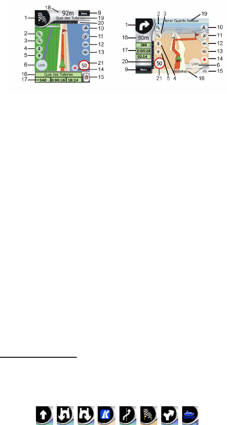
No. Display Control
1 (Cockpit only) Turn preview* Opens Route menu*
2 n/a Zooms in (optional)
3 n/a Zooms out (optional)
4 n/a Tilts down (optional)
5 n/a Tilts up (optional)
6 Indicates that Lock to GPS position and
heading is inactive
Re-enables Lock-to-Position / Smart Zoom
7 Selected map point (Cursor) Opens Popup Info and Cursor menu
8 (Map only) Map scale Zooms in/out by dragging
9 n/a Menu (Find, Quick, Route, Main)
10 Map orientation and Overview Switches North-up, Track-up and Overview
11 GPS position quality Opens GPS Data screen
12 Battery status Opens settings
13 Sound on or muted Enables/disables muting
14 Track Log recording or playback Opens Track Log screen
15 n/a Opens Cursor menu
16 (Cockpit only) Current street Opens Route Information screen
17 (Cockpit only) Travel and Route data** Opens Route Information screen
18 (Cockpit only) Distance to next turn*** n/a
19 (Cockpit only) Next street*** n/a
20 (Cockpit only) Approaching next turn**** n/a
21 Current speed limit*****
* On Map screen only when a route is active
** Contents differ when a route is active
*** Appears only when a route is active
**** Appears only when a route is active and the next turn is near
***** Appears only if speed limit is known for the current road
4.3.1 Turn preview (No. 1)
On the Cockpit screen this field shows a graphic illustration of the next manoeuvre.
For example when you approach a turn, an arrow will show whether it is a slight,
normal or sharp turn. When showing a roundabout, the number of the exit is also
given in the picture.
28