
DigiWalker User Manual P350 P550


Table Of Contents
- 1 Warnings and safety information
- 2 General information
- 3 Operating Mio Map (Controls)
- 3.1 Hardware buttons
- 3.2 Screen buttons and controls
- 4 Discovering the program through the screens
- 4.1 Main menu
- 4.2 The map
- 4.2.1 2D and 3D map views
- 4.2.2 Zoom levels
- 4.2.3 Daylight and night colour schemes
- 4.2.4 Streets and roads
- 4.2.5 Other objects
- 4.2.6 Current position and Lock-on-Road
- 4.2.7 Selected map point, also known as the Cursor
- 4.2.8 Visible POIs (Points of Interest)
- 4.2.9 Speed cameras
- 4.2.10 Contacts
- 4.2.11 Elements of the Active Route
- 4.3 Screens with map
- 4.3.1 Turn preview (No. 1)
- 4.3.2 Zoom in and out (No. 2 & 3)
- 4.3.3 Tilt up and down (No. 4 & 5)
- 4.3.4 Lock to GPS position and heading (No. 6)
- 4.3.5 Cursor (No. 7)
- 4.3.6 Map scale (No. 8)
- 4.3.7 Menu (No. 9)
- 4.3.8 Map orientation and Overview (No. 10)
- 4.3.9 GPS position quality (No. 11)
- 4.3.10 Battery status (No. 12)
- 4.3.11 Sound muting (No. 13)
- 4.3.12 Track Log recording/playback indicator (No. 14)
- 4.3.13 Cursor menu (No. 15)
- 4.3.14 Current street (No. 16)
- 4.3.15 Travel and Route data (No. 17)
- 4.3.16 Distance to next turn (No. 18)
- 4.3.17 Next street / Next settlement (No. 19)
- 4.3.18 Approaching next turn (No. 20)
- 4.3.19 Current speed limit (No. 21)
- 4.4 GPS Data screen
- 4.5 Route Information screen
- 4.6 Menu
- 4.7 Speed cameras
- 4.8 TMC
- 5 Find
- 5.1 Main menu Find buttons (Address, Favourites, POI, History)
- 5.2 Selection by tapping the map
- 5.3 Using the Find menu
- 5.3.1 Find an Address, Street, Intersection or City
- 5.3.2 Find in History
- 5.3.3 Find Coordinates
- 5.3.4 Find a POI
- 5.3.5 Find one of the Favourites (Home/Work)
- 6 Settings
- 6.1 General settings
- 6.2 Sound settings
- 6.3 Route parameter settings
- 6.4 Language & Units
- 6.5 Advanced settings
- 6.6 About screen
- 6.7 Manual GPS configuration
- 7 Troubleshooting guide
- 8 Glossary
- 9 Index
Tap the icon again to return to Track-up (automatic rotation) mode.
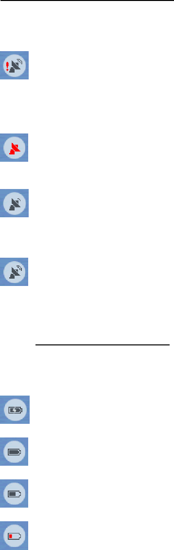
4.3.9 GPS position quality (No. 11)
Similarly to the icon found on the GPS Data screen (4.4.3), the map screens also
inform you about the GPS signal. They can show the same four values:
• The black satellite dish with the red exclamation mark shows there is no
connection with the GPS receiver. GPS navigation is not possible. You Mio
DigiWalker has a built-in GPS receiver that is permanently connected. This
icon may not appear under normal circumstances.
• Red shows there is a connection, but the signal is too weak to give a
position. GPS navigation is not possible.
• Black shows there is a GPS position, and navigation is possible. When
only one arc is shown, the position is 2D (no altitude available), and position
error may be significant, yet Mio Map is ready to navigate.
• A black dish and two arcs represent a 3D GPS position. Mio Map is
ready to navigate.
4.3.10 Battery status (No. 12)
The status of the battery is also shown by Mio Map. You can estimate the available
power reserve from the length of the bar inside. Some examples:
• The thunderbolt in the battery shows the battery is being charged.
Battery is not charging, but it is at full capacity.
•
•
Battery in not full, but there is sufficient reserve capacity.
• When the inside of the battery turns red, the battery needs recharging.
32