
DigiWalker User Manual P350 P550


Table Of Contents
- 1 Warnings and safety information
- 2 General information
- 3 Operating Mio Map (Controls)
- 3.1 Hardware buttons
- 3.2 Screen buttons and controls
- 4 Discovering the program through the screens
- 4.1 Main menu
- 4.2 The map
- 4.2.1 2D and 3D map views
- 4.2.2 Zoom levels
- 4.2.3 Daylight and night colour schemes
- 4.2.4 Streets and roads
- 4.2.5 Other objects
- 4.2.6 Current position and Lock-on-Road
- 4.2.7 Selected map point, also known as the Cursor
- 4.2.8 Visible POIs (Points of Interest)
- 4.2.9 Speed cameras
- 4.2.10 Contacts
- 4.2.11 Elements of the Active Route
- 4.3 Screens with map
- 4.3.1 Turn preview (No. 1)
- 4.3.2 Zoom in and out (No. 2 & 3)
- 4.3.3 Tilt up and down (No. 4 & 5)
- 4.3.4 Lock to GPS position and heading (No. 6)
- 4.3.5 Cursor (No. 7)
- 4.3.6 Map scale (No. 8)
- 4.3.7 Menu (No. 9)
- 4.3.8 Map orientation and Overview (No. 10)
- 4.3.9 GPS position quality (No. 11)
- 4.3.10 Battery status (No. 12)
- 4.3.11 Sound muting (No. 13)
- 4.3.12 Track Log recording/playback indicator (No. 14)
- 4.3.13 Cursor menu (No. 15)
- 4.3.14 Current street (No. 16)
- 4.3.15 Travel and Route data (No. 17)
- 4.3.16 Distance to next turn (No. 18)
- 4.3.17 Next street / Next settlement (No. 19)
- 4.3.18 Approaching next turn (No. 20)
- 4.3.19 Current speed limit (No. 21)
- 4.4 GPS Data screen
- 4.5 Route Information screen
- 4.6 Menu
- 4.7 Speed cameras
- 4.8 TMC
- 5 Find
- 5.1 Main menu Find buttons (Address, Favourites, POI, History)
- 5.2 Selection by tapping the map
- 5.3 Using the Find menu
- 5.3.1 Find an Address, Street, Intersection or City
- 5.3.2 Find in History
- 5.3.3 Find Coordinates
- 5.3.4 Find a POI
- 5.3.5 Find one of the Favourites (Home/Work)
- 6 Settings
- 6.1 General settings
- 6.2 Sound settings
- 6.3 Route parameter settings
- 6.4 Language & Units
- 6.5 Advanced settings
- 6.6 About screen
- 6.7 Manual GPS configuration
- 7 Troubleshooting guide
- 8 Glossary
- 9 Index
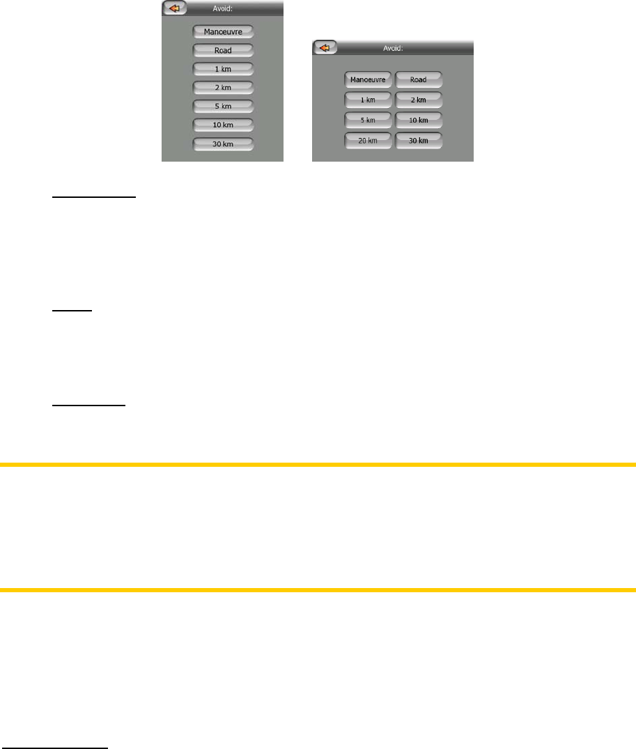
Tap this button to show a list of possibilities for modifying the route. They let you
recalculate the route avoiding the highlighted event and sometimes also some of the
subsequent ones.
Manoeuvre
•
: this option avoids the highlighted action. For example if you find a
turn too difficult during rush hour traffic, Mio Map will recalculate the route
excluding that turn. If the next street is important in the route, it is likely that
Mio Map will replace the turn with several easier ones to get to the same
street.
•
Road: when you exclude a road, Mio Map will calculate a route that does not
use that road. It is useful when you anticipate a traffic jam in a street used in
your route, or a roadblock is announced on the radio, and you find that road in
your Itinerary.
• Distances: you can also find some distance buttons in this list. They are similar
to the ones in the Bypass list of the Recalculation menu (4.6.3.1), but these
can also be used for distant parts of the route.
Note: You need not open Itinerary if you run into a roadblock or traffic jam. To get an
immediate alternative route use the Bypass function of Recalculate (4.6.3.1).
Note: When you use this feature, Mio Map will keep on excluding the same part of
the map from later routes until you manually delete the route (
4.6.3.2), or restart Mio
Map.
4.6.3.4 Fly Over
This feature has no navigation function, it merely provides a quick view of the route. It
will present a simulation of the route showing what you will see later when navigating.
There are two possibilities for running the simulation.
Fast Fly Over
Press and hold the Tilt down button (3.1.2) then tap Fly Over to quickly run through
the route. Mio Map will fly the route in Cockpit mode at high speed to give you a
rough overview of the route events. Mio Map is tweaked to give you a smooth and
easy-to-follow playback even at this speed.
This mode is useful if you want to have a look at the route before you start your
journey. Tap anywhere on the screen to stop the simulation.
54