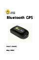
Bluetooth GPS User’s Guide May 2004
Table of Contents Trademarks 3 Welcome ........................................................................................4 In the Box ..................................................................................4 Getting Started...............................................................................5 Installation and Setup................................................................5 Bluetooth connection 6 PDA users 6 Laptop and Tablet PC users 7 Using the GPS for the first time........
You can find additional product and support information at the following website: http://www.mobilecrossing.com or contact: Mobile Crossing 1230 Oakmead Parkway, Suite 304 Sunnyvale, CA 94085 (408) 738-8816 (800) 605-8198 Fax 408.738.8806 email: support@mobilecrossing.com © 2004 Mobile Crossing - All rights reserved Trademarks Bluetooth is a trademark of Bluetooth SIG, Inc. Velcro is a trademark of Velcro Industries B. V. Pocket PC is a trademark of Microsoft Corporation.
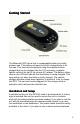
Welcome ® Thank you for your purchase of the Mobile Crossing Bluetooth GPS receiver. This GPS receiver will work world wide to compute your position wherever you are. It outputs standard NMEA sentences and will work with just about every navigation program available. The unit requires Bluetooth support on your PDA or laptop. It has its own rechargeable battery or can receive power from an external connection. In the Box The Box contains the following items 4 • The Bluetooth GPS.
Getting Started The Bluetooth GPS has a built in rechargeable battery for totally wireless use. This battery will need to be fully charged prior to its first use. This can be accomplished using the supplied vehicle charger that can be plugged into the 12V accessory (cigarette lighter) outlet in the car or the include AC adaper. The battery status lamp on the GPS will indicate that the battery is being charged. This lamp will go out when the battery is fully charged.
then the unit can be installed in any location where the antenna cable will reach and the power switch can be accessed. It is possible to leave this unit on all of the time if a permanent source of external power is provided. Some accessory outlets are live all of the time and can be used for this purpose. Many outlets turn off when the car ignition is turned off. The unit will revert to the battery under these conditions which will continue to supply power for up to 8 hours for continuous service.
An application is needed to take advantage of the GPS signal. The included CDROM contains a test program called GPSInfo that can be used to verify operation on a pocket pc. There is a description of GPSInfo on page 12 later in this manual. In most cases you will need to configure the software to tell it where the GPS is connected. Some software does have the ability to search for the GPS in automatic mode, but otherwise you will need to determine the COM port manually.
by the driver when it was installed. The Baud rate will need to be set to 4800. The CDROM contains the GPS Information command which can be used for test purposes. This unit has a built-in battery for power. The battery will last about 8 hours on a full charge. External power is recommended for extended or unlimited use in a vehicle. A vehicle power converter / recharger is included.
5. The GPS Status lamp on the receiver will light whenever the unit is turned on. It will immediately attempt to acquire satellite signals. 6. Observe the display in the application to determine if the receiver is able to communicate to the application and is able to see some satellites. 7. Wait! A receiver in a totally new location can take 5 to 10 minutes to determine its first location. In some cases it could even take longer. 8.
When hiking, hold the unit horizontally with the antenna up. If you put the unit in your pocket, be sure that the antenna is faced out. The body blocks all GPS signals. Some cars have a metalized sunscreen embedded in the windshield which blocks the GPS signals. An external antenna placed on the outside of the car will solve this problem. Suitable locations include the roof, the hood, the trunk area, or the top of the fenders.
• The GPS Status LED is green. It blinks when a GPS fix has been achieved and remains solid when the unit is searching for a fix. • The Battery Status LED is yellow or red. It shows yellow while charging is taking place and turns off when charging is complete. On battery power it remains off when there is adequate battery power. It lights red when the unit needs to be recharged. Recharge as soon as possible.
Information GPS Info rmation GPS Information from Globalsat Technology Corporation is included to provide a troubleshooting tool for any GPS problems that might be encountered. It is available for Pocket PC and PC systems. It can be used to reset the GPS device and provides analysis data about a fix. It can also be used to enable WAAS on the GPS device. It does not report whether WAAS is in use. WAAS is an augmentation system that can provide increased accuracy in some situations.
have a clear sky view and are willing to wait until a new GPS fix is obtained. • VTG checked will add this message to the NMEA strings of data. You should not do this unless a program specifically needs it. • Power Save can save significant amounts of battery power but at a cost in performance. Use this at your own discretion, but it is not recommend under difficult reception conditions. The WAAS switch can be used to toggle the differential correction capability on or off.
computed with respect to Universal Time Coordinated (UTC) which used to be called GMT (Greenwich Mean Time). The time is computed at longitude 0 which passes through England. California is 8 hours later than UTC (7 hours during DST). The other information shown includes the Velocity (Speed and Direction) and the Position (Latitude and Longitude) except that altitude is missing. The rest of the text is concerned with the quality of the fix itself.
conditions could leave the unit in SiRF mode and not available for NMEA. If you can make a Bluetooth connection but cannot communicate with the unit from your GPS application, it may be because it was locked in SiRF mode. You can try a Reset in GPS Info to clear the unit or let the internal battery run down completely. After the battery has completely run down the unit will return to factory defaults which includes NMEA mode.
GPS Technical Specifications Accuracy 15 meters 2D RMS Datum WGS 84 Hot Start 8 sec. Average Warm Start 38 sec. Average Cold Start 80 sec. Average Reacquisition 100 ms. Average GPS output data GGA, GSA, GSV, RMC, VTG, GLL Transfer Rate 4800, 8, n,1 Update Rate 1 Hz Operating Temperature -20° - 60° C Storage Temperature -40° - 85° C Power 8 hours per charge External Antenna MMCX connector Dimensions 3.54” x 1.97” x 0.63” All specifications are subject to change without notice.
Regulatory Notice FCC Notice This equipment has been tested and found to comply with the limits for a Class B digital device, pursuant to Part 15 of the FCC Rules. These limits are designed to provide reasonable protection against harmful interference in a residential installation. This equipment generates, uses, and can radiate radio frequency energy, and if not installed and used in accordance with the instructions, may cause harmful interference to radio communications.
issued by the Commission of the European Community and if this product has telecommunication functionality, the R&TTE directive (1995/5/EC).