
User's Guide
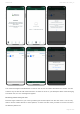
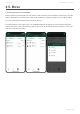
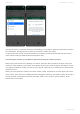
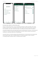

Sharing of data to Nofence’ official Grazing map
Nofence’ official Grazing map is a service that allows the farmer to share the animals’ most current
positions as well as their current grazing boundary with the public. Many animals graze on grounds
where members of the public are passing through, and making the animals positions and pasture
boundaries available through the Grazing map could be of great benefit to the farmer. You are also able
to share your contact info (name and email address) in the map, allowing members of the public to
contact you in case they notice a sick or injured animal.
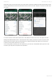
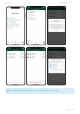
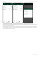
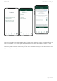
Under this section you also find grazing posters with QR codes. The codes directs to the Grazing map
and the posters further inform of animals grazing in the area using Nofence collars, as well as
encourages people to keep their dogs on a lead around the animals.
Nofence AS User Guide - UK - 2021_en
Page 42 of 63