Quick Start Guide For Packard Bell COMPASSEO 370, 470 and 770 April 2008 Version 2.
NAVFDRIVE FOR THE COMPASSEO 470 NAVFDRIVE is a full-featured mobile satellite navigation system. It utilizes GPS (Global Positioning System) satellites to pinpoint your location using the latest mapping data technology to get you to your destination in the most efficient and timely manner and assists you in planning your route by providing Turn-by-Turn signals, accompanied by Audio and Visual instructions.
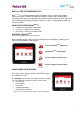
ACCESSING NAVFDRIVE To access the NAVFDRIVE application, press the NAVI button in the Welcome screen. The NAVFDRIVE Navigation Menu will open, allowing you a few ways to start your navigation. Planning Your Navigation Route Press the Planner button to immediately start planning your route. You may choose to enter your From (Start) Point and To (Destination) Point by doing an address search or selecting from a favourites list. A Start Point can also be entered using the current GPS position.
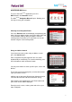
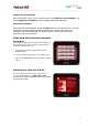
Setting Your Preferred Route From your Planner screen, you can select to route via the Highway or Avoid Highway. Tap on the ‘Highway/Avoid Highway’ button to toggle between the two options. Starting Your Navigation To proceed with your Navigation, tap on the Route button in your Planner screen. This will confirm your route plan and launch the Navigation Map, automatically starting your navigation. You will be guided with turn-by-turn signals as well as audio and visual instructions.
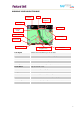
KNOWING YOUR NAVIGATION MAP Distance to Next Turn ETA Distance to Destination Turn Signal GPS Signal Next Turn Road North Compass Zoom Button Zoom Scale Current Road Navigation Arrow Route Line Turn Signal Shows the next turn that you are to make. Distance to Next Turn Distance to the next turn that you are going to make. ETA Estimated time of arrival at the destination. Distance to Destination Estimated distance remaining to destination.