
Owner's Manual
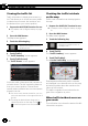
Table Of Contents
- Quick Start Guide
- Operation Manual
- Reset (Button #8)
- Bluetooth PIN (0000)
- Demo Mode
- Setting Time and Date
- Removing / Attaching Faceplate
- First-Time Startup
- Table of Contents
- Parts & Controls
- Operation
- Basic Operation
- Front Panel Controls
- Remote Control (8200NEX / 6200NEX)
- Notes on LCD Panel Use
- Adjusting the LCD Panel Angle
- Inserting / Ejecting / Connecting Media
- First-Time Startup
- How to Use the Screens
- Supported AV Sources
- Displaying the AV Operation Screen
- Selecting a Source
- Changing the Display Order of the Sources
- Using the Touch Panel
- How to Use the Navigation Menu Screen
- How to Use the Map
- Searching for a Destination
- Checking and Modifying the Current Route
- Registering and Editing Locations and Routes
- Receiving Real-Time Traffic Information (TMC)
- Checking useful Information About Your Trip
- Customizing Preferences of the Navigation
- Bluetooth Connection
- Hands-Free Phoning
- Setup for iPod / iPhone or Smartphone
- Radio (5200NEX)
- HD Radio (8200NEX / 7200NEX / 6200NEX)
- Disc Operation
- Compressed Files
- iPod
- AppRadio Mode
- Apple CarPlay
- Android Auto
- Pandora
- Bluetooth Audio Player
- SiriusXM Satellite Radio
- HDMI Source
- AUX Source
- AV Input
- MIXTRAX
- iDatalink
- System Settings
- Audio Adjustments
- Theme Menu
- Video Settings
- Favorite Menu
- Other Functions
- Basic Operation
- System Settings
- Audio Adjustments
- Theme Menu
- Video Settings
- Favorite Menu
- Other Functions
- Troubleshooting
- Messages
- Specs
- Installation Manual
- AVICSYNC app Operation Manual
- Important Information for the User
- Scan of CD-ROM
- Warranty

Customizing the in-car
navigation settings
In this section, only the preferences related to
the AVICSYNC function are described.
Other operations are basically the same as on
the in-car navigation system. For information
on other functions, please read the operation
manual for your in-car navigation system.
You can configure the navigation settings, and
modify the behavior of your in-car navigation
system.
1 Press the MAP button.
The Map screen appears.
2 Touch the following key.
Displays the navigation menu on
the Map screen.
3 Touch to show the next page.
4 Touch [Settings].
The “Settings” screen appears.
Information on each option of
“Settings”
“Sound” settings
Announce Traffic Info
You can select whether to have the navigation
system announce by voice the traffic informa-
tion whenever a traffic incident on your route
is received.
“Navigation Map” settings
Offer Congestion Detour on Highways
(Motorways)
When you slow down while driving on a free-
way (motorway) due to a traffic congestion
(traffic jam), this navigation system offers you
a detour using the next exit. The message
shows you the distance to the exit and the dif-
ference in the distance and estimated time
compared to the original route. You can
choose from one of the following options:
! Touch [Dismiss] or just ignore the message
if you want to keep the original route.
! Touch [Preview] to see an overview of the
original route and the detour to make the
decision. You can accept the detour as
shown in the preview, or increase the free-
way (motorway) segment bypassed before
accepting.
! Turn to the suggested new direction and
the route will be automatically recalcu-
lated.
Offer Real-time Route Alternatives
Alternative routes can be suggested when
driving on normal roads. This navigation sys-
tem will select a different turn in the upcom-
ing intersection and offer you a different route
for the next section of the route. You cannot,
however, modif y the offered detour.
“Traffic” settings
Traffic
You can set to enable or disable the traffic in-
formation feature.
Data Source
You can select what data source you want to
use for receiving real-time traffic information.
[Online] is available only if the device is en-
abled.
Show Traffic Info
You can select whether to show icons relevant
to traffic incidents and lines indicating the
traffic flow on the map.
! Off
No traffic icons or lines indicating the traf-
fic flow are shown.
! Color
Only the line relevant traffic incidents are
shown on the map.
! Color And Icon
En
24
Chapter
06
Customizing preferences of the navigation