
Owner's Manual


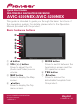

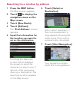

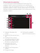
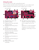
Table Of Contents
- Quick Start Guide
- Operation Manual
- Reset (Button #8)
- Bluetooth PIN (0000)
- Demo Mode
- Setting Time and Date
- Removing / Attaching Faceplate
- First-Time Startup
- Table of Contents
- Parts & Controls
- Operation
- Basic Operation
- Front Panel Controls
- Remote Control (8200NEX / 6200NEX)
- Notes on LCD Panel Use
- Adjusting the LCD Panel Angle
- Inserting / Ejecting / Connecting Media
- First-Time Startup
- How to Use the Screens
- Supported AV Sources
- Displaying the AV Operation Screen
- Selecting a Source
- Changing the Display Order of the Sources
- Using the Touch Panel
- How to Use the Navigation Menu Screen
- How to Use the Map
- Searching for a Destination
- Checking and Modifying the Current Route
- Registering and Editing Locations and Routes
- Receiving Real-Time Traffic Information (TMC)
- Checking useful Information About Your Trip
- Customizing Preferences of the Navigation
- Bluetooth Connection
- Hands-Free Phoning
- Setup for iPod / iPhone or Smartphone
- Radio (5200NEX)
- HD Radio (8200NEX / 7200NEX / 6200NEX)
- Disc Operation
- Compressed Files
- iPod
- AppRadio Mode
- Apple CarPlay
- Android Auto
- Pandora
- Bluetooth Audio Player
- SiriusXM Satellite Radio
- HDMI Source
- AUX Source
- AV Input
- MIXTRAX
- iDatalink
- System Settings
- Audio Adjustments
- Theme Menu
- Video Settings
- Favorite Menu
- Other Functions
- Basic Operation
- System Settings
- Audio Adjustments
- Theme Menu
- Video Settings
- Favorite Menu
- Other Functions
- Troubleshooting
- Messages
- Specs
- Installation Manual
- AVICSYNC app Operation Manual
- Important Information for the User
- Scan of CD-ROM
- Warranty

How to use the map
Most of the information provided by your navigation system can
be seen on the map. You need to become familiar with how the
information appears on the map.
The following information marked with an asterisk (*) appears only
when a route is set.
AV information is displayed at the bottom of the Map screen.
1 Shows the number and
name of the street to be
used (or next guidance
point).*
2 Shows the next guidance
point (maneuver).*
3 Shows the distance to
the next guidance point
(maneuver).*
4 Shows the maneuver after
the next maneuver.*
5 Indicates the current
location of your vehicle.
6 Displays the time and
distance information for
your route.*
7 Shows the name
of the
street (or city) that your
vehicle is traveling on (or
in).
8 Indicates the current route.*
9 Displays the Navigation
menu screen.
a Indicates the progress to the
final destination.*