
Owner's Manual
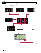
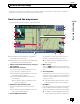
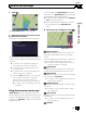
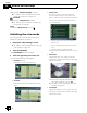
Table Of Contents
- Quick Start Guide
- Operation Manual (Supplied on CD-ROM Only)
- Restore Default Settings
- Table of Contents
- Using This Manual
- Parts & Controls
- Operation
- Basic Operation
- Using the Navigation Menu Screens
- Using the Map
- Eco-Friendly Driving Functions
- Searching for and Selecting a Location
- After the Location is Decided
- Checking and Modifying the Current Route
- Registering and Editing Locations
- Using Traffic Information
- Registering and Connecting a Bluetooth Device
- Using Hands-Free Phoning
- Basic Operations of the AV Source
- Using the Radio
- HD Radio
- Playing Audio CDs
- Playing Music Files on ROM
- Playing a DVD-Video
- Playing a DivX Video
- DVD-Video or DivX Setup
- Playing Music Files (from USB or SD)
- Playing Video Files (from USB or SD)
- Using an iPod
- Using Pandora
- Using Aha Radio
- Using the Bluetooth Audio Player
- Using the XM Tuner
- Using the SIRIUS Tuner
- Using AV Input
- Using the External Unit (EXT1, EXT2)
- Customizing Preferences
- Operating your Navigation System with Voice
- Setting the Anti-Theft Function
- Returning the Navigation System to the Default or Factory Settings
- Troubleshooting
- Messages
- Additional Information
- Glossary
- Specs
- Installation Manual
- Upgrade Instructions and Operation Manual Addendum (Use after Upgrading with 130SD239FM)
- Table of Contents
- Compatibility
- Using This Manual
- iPod Compatibility
- Instructions for Upgrading
- How to use the Navigation Menu Screens
- How to use the Map
- Eco-Friendly Driving Functions
- Searching for and Selecting a Location
- After the Location is Decided
- Checking and Modifying the Current Route
- Registering and Editing Locations
- Using Hands-Free Phoning
- Fuel Cost Management
- Using Applications
- Basic Operations of the Audio Source
- Using the Tuner
- HD Radio
- Playing Audio CDs
- Playing Music Files on ROM
- Playing Music Files on USB
- Using an iPod
- Using the XM Tuner
- Using the SIRIUS Tuner
- Using an External Unit (EXT1, EXT2)
- Using the AUX Source
- Customizing Preferences
- Other Functions
- Troubleshooting
- Messages
- Important Information for the User
- Scan of CD-ROM
- Warranty

8 Street name (or city name) that your vehi-
cle is traveling along
= For details, refer to Setting the current
street name display on page 158.
9 Extension tab for the AV information bar
Touching this tab opens the AV information
bar and enables you to briefly view the current
status on the AV source. Touching it again re-
tracts the bar.
a Shortcut to the AV operation screen
The AV source currently selected is shown.
Touching the indicator displays the AV opera-
tion screen of the current source directly.
p Depending on the source currently cho-
sen, an image is displayed.
b Quick Access icon
Displays the “Quick Access” menu.
= For details, refer to Using shortcut
menus on the map on page 29.
c Map orientation indicator
! When “North up” is selected, is dis-
played.
! When “Heading up” is selected,
is
displayed.
p The red arrow indicates north.
= For details, refer to Switching the map or-
ientation on page 28.
d Current route*
The route currently set is highlighted in color
on the map. If a waypoint is set on the route,
the route after the next waypoint is high-
lighted in another color.
e Direction line*
The direction towards your destination (next
waypoint, or the position of a cursor) is indi-
cated with a straight line.
f Multi-Info window
Each touch of Multi-Info window changes the
display information as follows.
! Distance to the destination (or dis-
tance to waypoint)*
! Estimated time of arrival at your des-
tination or waypoint*
The estimated time of arrival is an ideal
value calculated based on the value set
for “Average Speed” and the actual
driving speed. The estimated time of ar-
rival is only a reference value, and does
not guarantee arrival at that time.
! Travel time to your destination or
waypoint*
g Current time
Meaning of guidance flags
Destination
The checkered flag indicates your
destination.
Waypoint
The blue flags indicate your way-
points.
Guidance point
The next guidance point (next turn-
ing point, etc.) is shown by a yel-
low flag.
Enlarged map of the intersection
When “Close Up View” in the “Map Settings”
screen is “On”, an enlarged map of the inter-
section appears.
= For details, refer to Setting the auto-zoom
display on page 156.
En
26
Chapter
04
How to use the map