
Operation Manual


EN-10
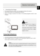
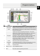
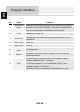
No. Name Function
9
Information
panel
Shows the name of the street you are currently driving along.
Available only if GPS/GLONASS connection is established. If
there is no street name, the direction will be shown.
10 2D/3D Switches 2D/3D format.
11 Traffic lane
Displays the traffic lanes with a valid maneuvers at the next
intersection.
12 Scale button Zoom out.
13 Scale button Zoom in.
14
Information
panel
Following street.
15 Battery
Icon shows the level of battery charge. Press it to see the
remaining memory.
16 GPS
GPS/GLONASS connection icon. If the indicator is grey —
receiver is disabled, red — switched
on, but the connection is not established, yellow - poor
connestion, green - connection
established. There is a number of the satellites in the dot.
Program interface
EN