
Specifications


178mm
96mm
190mm
176mm
63mm
84
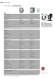
SPECIFICATIONS
GPS Standalone Chartplotters
GENERAL
Power:
Nominal voltage (volts DC)
Absolute voltage range (volts DC)
Power consumption (typical) watts
Physical:
Overall dimensions (WxHxD) mm
Product weight kg (lbs)
Mounting methods
Control type(s)
Cursor (context sensitive)
Colour/mono
Display size and type
Display resolution
Display lighting
Connections:
NMEA input (0183) (WPL, RTE)
NMEA output (0183)
(GGA, GLL, RMC, VTG, GSA, GSV, PRAYA, 6, XTE, BWR, RMB, APB, WPL, RTE)
Cartography
Approvals:
EMC (Europe and FCC)
CE marked
Environmental:
Operating temperature range
Non-operating temperature range
Humidity
Waterproofi ng standard
KEY FEATURES
Range scales
Range options
Max. detail of background map
Head up/north up/course up
True/magnetic (variation source)
Waypoints
Waypoint name
Waypoint storage
Waypoint entry
Manual waypoint entry
Waypoint transfer
PC Waypoint transfer (via NMEA WPL sentence)
Routes
Route name
Route storage
Waypoints per route
Tracks
Points per track
Track interval
Smart Route (track to route)
Alarms
Timers
Navigation information
Navigation predictions
GOTO/follow functions
Tidal information supported
Sunrise/sunset predictions
Man Over Board (MOB)
GPS FEATURES
Type
Signal acquisition
Satellite Differential type
Differential acquisition
Position accuracy (RMS)
Position accuracy with SDGPS (RMS)
Speed accuracy (RMS)
Filters
Time to fi rst fi x from cold start (typical)
Time to fi rst fi x (after initial cold start)
Geodetic datum
Position correction
ADDITIONAL FEATURES and DISPLAY OPTIONS
Course deviation indicator (rolling road)
Bearing and distance indicator
Data pages
* WAAS (Wide Area Augmentation System) has been operational since August 2000 and is available for navigation purposes in
Canadian and US waters. EGNOS (European Geostationary Navigation Overlay System) is under development in Europe and should be
used with caution until its official deployment sometime during 2006. MSAS (MTSAT ((Multifunction transport satellite)) Satellite-based
Augmentation System), based in Asia, is also under development. SDGPS will be operational worldwide once these developments are
complete. For more details, please visit
www.raymarine.com
RAYCHART 435
12V system
10 - 18 volts
10W (fully backlit and GPS)
186x176x62
0.85 (1.89)
bracket or panel
6 defi ned keys
trackpad
colour
152mm (6") TFT Colour LCD
320x240 (1/4 VGA)
4 levels (adjustable)
✓
✓
Navionics Gold
✓
✓
-10°C to +70°C
-10°C to +70°C
up to 95%
CFR46
1/8 to 4096nm
16 scales
256nm with overzoom
✓
auto/manual
500
8 character
database/CF card
graphical/manual
LatLon
via NMEA
✓
20
8 character
database/CF card
up to 50
✓
1000
time/distance
✓
arrival/XTE/anchor/no fi x
✗
position/XTE/SOG/COG
TTG/ETA
waypoint/cursor/route
height and current via chart
✓
✓
external antenna
12ch. parallel (C/A code)
WAAS/EGNOS/MSAS
automatic
<15m
<5m
<0.3kts
dynamic fi lter depending on speed (SOG)
<3 min. (<90 sec)
typically <15 seconds
WGS84 or local
✓
✓
✓
3 full screen pages
RAYCHART 435i
12V system
10 - 18 volts
10W (fully backlit and GPS)
186x176x62
0.85 (1.89)
bracket or panel
6 defi ned keys
trackpad
colour
152mm (6") TFT colour LCD
320x240 (1/4 VGA)
4 levels (adjustable)
✓
✓
Navionics Gold
✓
✓
-10º to +70ºC
-10º to +70ºC
up to 95%
CFR46
1/8 to 4096nm
16 scales
256nm with overzoom
✓
auto/manual
500
8 character
database/CF card
graphical/manual
LatLon
via NMEA
✓
20
8 character
database/CF card
up to 50
✓
1000
time/distance
✓
arrival/XTE/anchor/no fi x
✗
position/XTE/SOG/COG
TTG/ETA
waypoint/cursor/route
height and current via chart
✓
✓
internal antenna
12ch. parallel (C/A code)
WAAS/EGNOS/MSAS
automatic
<15m
<5m
<0.3kts
dynamic fi lter depending on speed
< 3 min. (<90sec)
typically <15 seconds
WGS84
✓
✓
✓
3 full screen pages
GPS CHARTPLOTTERS
E33019 Raychart 435i chartplotter with
built-in GPS
E32040 Raychart 435 chartplotter complete
with external GPS antenna
RC435 AND RC435I
Page 40
for product information