E-Series Display Operating Guide www.raymarine.
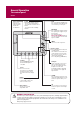
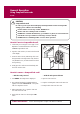
General Operation The control panel Card 1 DATA Press to access ruler, chart vectors, archive & transfer and data bar on/off functions. ACTIVE When multiple windows are open: - Press to select required window. - Press and hold to maximize current window. - Press again to return to multiple windows. PAGE Press to scroll through available pages. Press and hold to select different page set or customise your own layout. PAGE ACTIVE WPTS MOB DATA WPTS/MOB Press to display the waypoint soft keys.
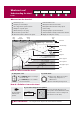
General Operation Using the controls Card 2 How do the controls work? Buttons PAGE Access system functions or change what you see on-screen. Within the text of this document they are written in bold capitals e.g. WPTS/MOB. ACTIVE WPTS/ MOB DATA Press and hold to access short cuts - see individual buttons on facing page. MENU Example: This example shows the series of button and soft key presses required to change the waypoint default symbol or group.
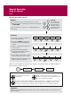
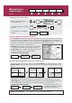
General Operation Setting up the display Card 3 How do I select how the applications are displayed? The applications are shown using a combination of page sets, pages and windows. There are five page sets each containing five pages with a combination of windows and applications in each. These sets can be edited to define the combination that suits your particular needs. Any changes you make will be saved to the system. You can change these preferences as many times as you wish.
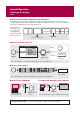
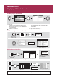
General Operation Using CompactFlash cards Card 4 CAUTION CompactFlash Card In order to protect your E-Series Display and CompactFlash cards from irreparable damage, please adhere to the following: Fit the card the correct way around. DO NOT force. Ensure card door is firmly closed at all times. DO NOT use a metallic instrument (e.g. screwdriver or pliers) to aid card removal. Follow the correct procedure for removing a card (see below). DO NOT remove card during either a read or write operation.
What can I see? FIND SHIP CURSOR Understanding the chart GOTO ROUTES TRACKS PRESENTATION Card 5 What can I use the chart for? Find where you are. Interpret your surroundings. Place waypoints at specific locations. Navigate to a specific point. Monitor where you are going. Record where you have been. Measure the distance between two points. Chart range Chart orientation 4nm North-Up Build and follow routes. Manage and edit routes and tracks.
What can I see? FIND SHIP CURSOR Using the chart ... GOTO ROUTES TRACKS PRESENTATION Card 6 Viewing detail on the chart Display additional information on a cartographic feature: OK OK For more information Setup To show/hide individual cartographic features: MENU To show/hide pre-set cartographic features: PRESENTATION... Cartography Setup...
What can I see? Displaying additional information Card 7 Viewing object information OK More detailed information for selected object displayed. Move cursor over object, to display basic information. You can now: Locate the nearest waypoint, port, port service, tidal and current stations, wreck or obstruction, to the selected position. View detailed data for the selected port, tidal or current station. View panoramic photographs (dependent on the type of chart card in use) Search for a named port.
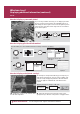
What can I see? Displaying additional information (continued) Card 8 How do I display a panoramic photo? If you are using a suitable chart card, you can display a panoramic photo(s) of many ports and marinas. The availability of photos is indicated by the camera symbol on the chart. This symbol is placed where the photo was taken and the angle of the shot is indicated by the camera symbol.
What can I see? FIND SHIP ADJUST ON EYE CENTRE GOTO Understanding the 3D chart ADJUST ROTATE PITCH PRESENTATION Card 9 What can I use the 3D chart for? If you are using a suitable chart card you will be able to: Synchronize the 2D and 3D chart. Display a 3D view of land, sea & features. Locate where you are. Interpret your surroundings. Monitor where you are going. Range Mode Go to an existing waypoint. Navigate a route.
What can I see? GOTO FIND SHIP Using the 3D chart ... ADJUST ON EYE CENTRE ADJUST ROTATE PITCH PRESENTATION Card 10 How do I find where I am on the 3D chart? Your position: Or If you cannot see your boat symbol: The 3D chart automatically redraws with the boat in forward looking view at your current position. FIND SHIP How do I change the motion mode? Using aerial photographs Active motion mode Default mode when 3D chart opened and there is a valid fix. Shows aerial view from above your boat.
Basic Navigation Working with Waypoints WAYPOINT AT CURSOR WAYPOINT AT VESSEL WAYPOINT AT LAT/LON GO TO WAYPOINT OPTIONS REVIEW AND EDIT WAYPOINTS Card 11 What is a waypoint? A waypoint is a position marked on a chart, radar or fishfinder screen to indicate a site (for fishing, diving etc), or as a position to go to. You can place a waypoint at the cursor or your boat's position or at a specified position.
Basic Navigation How do I get to a point? SHOW/HIDE ROUTES FOLLOW ROUTE OPTIONS REVIEW AND EDIT ROUTES BUILD NEW ROUTE Card 12 What is a route? A route is made up of a series of waypoints. These waypoints can either be placed specifically for that route and/or you can use existing waypoints. You can save a route for future use or follow it immediately (Quick Route). Routes are stored in a route list.
What is around me? VRM/EBL Understanding the radar TARGET TRACKING ENHANCE ECHOES... GAIN PRESENTATION Card 13 What does the radar show me?.... Range Range ring spacing Motion mode Orientation Data bar 3nm Head-Up Relative Motion Rings ½nm Icon confirming radar connection Range ring Ship's heading marker Boat's position Surface vessel Waypoint Landmass VRM/EBL... TARGET TRACKING... GAIN... ENHANCE ECHOES... PRESENTATION...
What is around me? TARGET TRACKING VRM/EBL Avoiding a collision ENHANCE ECHOES GAIN PRESENTATION Card 14 How can the radar help me avoid a collision? You can set up your E-Series Display to sound an alarm when anything comes within a pre-set range of the boat. These guard zones allow you to take any necessary action to avoid a collision. Guard zones A sector or circular zone fixed with respect to the Ships Heading Marker (SHM).
What is around me? MONITOR IN ZONES ACQUIRE TARGET MARPA & AIS OPTIONS AIS LIST MARPA LIST Using MARPA.... Card 15 What is MARPA? Mini Automatic Radar Plotting Aid (MARPA) functions are used for target tracking and risk analysis. MARPA improves your standards of collision avoidance by obtaining detailed information for up to 10 targets, and provides continuous and rapid situation evaluation.
What is around me? AIS VECTOR ON OFF AIS DATA AUTO ON OFF VIEW FULL AIS DATA Using AIS Card 16 AIS target symbols What is AIS? AIS uses digital radio signals to broadcast ‘realtime’ information between vessels and shore based stations via dedicated VHF frequencies. This information is used to identify and track vessels in the surrounding area and to provide collision avoidance data. AIS will augment your radar application, as it can operate in radar blind spots.
Where am I? Monitoring a course.... Card 17 How do I monitor my course?.... Your course is shown on the chart application whilst motion mode is active. Using COG and heading vectors (Press DATA - CHART VECTORS - COG/HDG VECTORS). Use the Course Deviation Indicator (CDI). With your display receiving accurate heading and position information, you can monitor your course and accurately steer to a target waypoint. What does the CDI show me?.... The CDI gives a graphical representation of your boat's course.
What's under the boat? Adjust P1 SINGLE PRESET 2 DUAL PRESET 3 SHALLOW PRESET 4 DEEP PRESENTATION Understanding the fishfinder Card 18 What's under the boat? The fishfinder application, when connected to a suitable Digital Sounder Module (DSM) and transducer, will help you to see fish, bottom structure and underwater obstructions. The image scrolls from right to left at an automatically selected range and frequency to provide a record of the echoes seen.
What's under the boat? Adjust P1 SINGLE PRESET 2 DUAL PRESET 3 SHALLOW PRESET 4 DEEP PRESENTATION Using the fishfinder.... Card 19 How do I change the range or shift the image? Your system automatically adjusts the display depth range, selecting the shallowest depth that keeps the bottom on the lower half of the window. You can however, set this manually if required and move the image within the selected page up or down. Using the range controls will affect all fishfinder windows.
Monitoring data and engines Viewing video images Card 20 How do I monitor data?.... NAVIGATION WAYPOINT ROUTE FISHING SAILING The data application enables you to view numeric data generated by the system or by instruments available on NMEA 0183, SeaTalk, SeaTalk2, NMEA 2000 and SeaTalkhs. This information is displayed in a series of panels which contain data relating to a particular function or activity. These can be reconfigured to your needs.
Navtex and Sirius Weather Data Card 21 Navtex If connected to a Navtex receiver, you can use your display to view navigation, meteorological and search and rescue alerts. You can choose which category of alerts will automatically be displayed when one is received by your display. After you have read the message you can either erase it or save it to the database (100 maximum). You can view the list of saved messages at any time. Messages are viewed and alerts setup via the Setup Menu option Navtex Messages.
Sirius Weather Data DISPLAY GRAPHICS FIND SHIP WEATHER REPORTS ANIMATE WEATHER PRESENTATION (continued) Card 22 By default, all weather graphics are set to OFF. To display the required weather graphic: Weather Graphics NOWRad Storm Cast Sea Surface Temp Canadian Radar DISPLAY GRAPHICS...
Autopilot Operation Using the Autopilot controls Card 23 How do I access Auto and Standby from my E-Series? Enabling the Autopilot from set up: To enable autopilot control on the E-Series display: Press the MENU button to open the Setup Menu. Select System Setup > System Integration > Autopilot Control > Enabled. Press the OK button. Enabling and engaging the autopilot To allow the E-Series to control autopilot functions, you need to enable autopilot control on the display unit.
What is around me? TARGET TRACKING VRM/EBL Understanding the digital radar Card 24 ENHANCE ECHOES... GAIN PRESENTATION What do the digital radar colors show me?.... Preset Dual gain Radar range range indicator mode Orientation Motion mode Range ring separation Radar status Icons Data bar Ships heading marker Ships position Land mass AIS target Range ring The colors displayed represent the strength of the echoes received from targets.
Operating a networked E-Series Display Card 25 What does a networked system do? If you have connected two or more E-Series Displays (via either a crossover coupler or SeaTalk High Speed Switch), all system data (from NMEA 0183, SeaTalk, SeaTalk2, NMEA 2000, SeaTalkhs waypoints, routes etc) can be transferred across the network enabling you to input, view and maintain data across all your displays irrespective of the Display from which the data originated (excepting Video Input).