Page2 of 18 WARNING: NAVIGATION AID This unit is only an aid to navigation. Its accuracy can be affected by many factors, including equipment failure or defects, environmental conditions, and improper handling or use. It is the User's responsibility to exercise common prudence and navigational judgement. This unit should not be relied upon as a substitute for such prudence and judgement. Always keep a proper look-out.
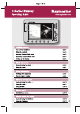
Page 3 of 18 Getting Started FIND SHIP GOTO ROUTES... TRACKS... PRESENTATION... The controls explained Card No. 1 DATA Pressing this button displays the data functions. ACTIVE When multiple windows are open: - Press to select required window. - Press and hold to maximise the current window. PAGE Press to scroll through available pages. Press and hold as a short cut to page set options. PAGE ACTIVE WPTS/ MOB WPTS/MOB Press to display the waypoint soft keys.
Page 4 of 18 Getting Started ROUTE… GOTO… FIND SHIP… TRACKS… PRESENTATION… Using the controls Card No. 2 How do the controls work? The controls for your C-Series Display can be separated into two types: Buttons Soft keys Buttons - allow you to access various functions of the display, or change what you see on the screen. Soft keys - There are five soft keys below the screen.
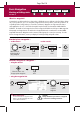
Page 5 of 18 Getting Started Inserting CompactFlash cards Card No. 3 CAUTION CompactFlash Card Installation When installing CompactFlash cards ensure that the card is being fitted the correct way around. DO NOT try and force the card as this may result in irreparable damage to the card. Water Ingress To prevent the ingress of water and consequent damage to the display, ensure that the chart card door is firmly closed at all times during operation. This can be confirmed by an audible click.
Page 6 of 18 Getting Started Removing CompactFlash cards Card No. 4 How do I remove a CompactFlash card? ... with the unit powered down To remove a card with the unit powered down, refer to the illustration and: ... with the unit powered To remove a card with the unit powered, refer to the illustration, and: 1. Open the chart card door. 1. Press MENU. The Setup menu is displayed. 2. Grip the card and pull to remove it from its slot. 2. Use trackpad up/down to highlight CF CARD REMOVAL. 3.
Page 7 of 18 Getting Started Setting up the display Card No. 5 How do I select how the applications are displayed? The applications are shown using a combination of page sets, pages and windows. There are four pre-configured page sets each containing four pages with a combination of windows and applications in each. If these sets are not appropriate, you can use the custom option to define the combination that suits your particular needs.
Page 8 of 18 What can I see? FIND SHIP GOTO ROUTES TRACKS PRESENTATION Understanding the chart Card No. 6 What does the chart show me? The chart shows a high level of cartographic detail to help: - Interpret your surroundings. - Navigate to a specific point. - Monitor where you are going. - Record where you have been. - Build and follow routes.
Page 9 of 18 What can I see? FIND SHIP GOTO ROUTES TRACKS PRESENTATION Using the chart ... Card No. 7 How do I find where I am on the chart? If you cannot find your boat's position on the screen: FIND SHIP The screen automatically pans to your boat's position. Press How do I change the chart orientation? The orientation of the chart refers to the relationship between the chart and the direction that you are travelling in.
Page 10 of 18 Basic Navigation WAYPOINT AT CURSOR Working with Waypoints WAYPOINT AT VESSEL WAYPOINT AT POSITION ... GO TO WAYPOINT OPTIONS ... REVIEW AND EDIT WAYPOINTS Card No. 8 What is a waypoint? A waypoint is a position marked on a chart, radar or fishfinder screen to indicate a site (for fishing, diving etc), or as a position to go to. You can place a waypoint at the cursor position, your boat's position or at a specified position (using Lat/Long or Loran TD co-ordinates).
Page 11 of 18 Basic Navigation How do I get to a point? SHOW/HIDE ROUTES FOLLOW ROUTE BUILD NEW ROUTE OPTIONS TRACKS REVIEW AND EDIT ROUTES Card No. 9 What is a route? A route is made up of a series of waypoints. These waypoints can either be placed specifically for that route and/or you can use existing waypoints. You can save a route for future use or follow it immediately (Quick Route). Routes can be named, edited, erased and archived.
Page 12 of 18 What is around me? VRM/EBL Understanding the radar TARGET TRACKING GAIN TARGETS PRESENTATION Card No. 10 What does the radar show me?....
Page 13 of 18 What is around me? VRM/EBL Using the radar.... TARGET TRACKING GAIN TARGETS PRESENTATION Card No. 11 How can the radar help me avoid a collision? You can set up your C-Series Display to sound an alarm when anything comes within a pre-set range of the boat. This will allow you to take any necessary action to avoid a collision. Guard zones A sector or circular zone fixed with respect to the Ships Heading Marker (SHM).
Page 14 of 18 What is around me? Using MARPA.... MONITOR IN ZONES ACQUIRE TARGET MARPA LIST MARPA OPTIONS Card No. 12 What is MARPA? Mini Automatic Radar Plotting Aid (MARPA) functions are use for target tracking and risk analysis. MARPA improves your standards of collision avoidance by obtaining detailed information for up to 10 targets, and provides continuous and rapid situation evaluation.
Page 15 of 18 Where am I? FIND SHIP GOTO ROUTES TRACKS PRESENTATION Monitoring a course.... Card No. 13 How do I monitor my course?.... With your display receiving accurate heading and position information, you can use the Course Deviation Indicator (CDI) to monitor your course and accurately steer to a target waypoint. What does the CDI show me?.... The CDI gives a graphical representation of your boat's course.
Page 17 of 18 Whats under the boat? Using the fishfinder.... TRANSDUCER SETTINGS ZOOM BOTTOM LOCK A - SCOPE PRESENTATION Card No. 15 How do I change the range or shift the image? Your system automatically adjusts the display depth range, selecting the shallowest that keeps the bottom on the lower half of the window.
Page18 of 18 Raymarine Ltd. Anchorage Park Portsmouth, Hampshire England PO3 5TD +44 (0)23 9269 3611 +44 (0)23 9269 4642 fax www.raymarine.com Raymarine Inc. 22 Cotton Road, Unit D Nashua, NH 03063-4219 USA 603-881-5200 603-864-4756 fax www.raymarine.