Rikaline GPS-6017 GPS Receiver SiRF Star III User’s Guide Dec. 13, 2005 Rikaline International Corp. 14F, 171, ChenGong Rd., Sanchong City, Taipei 241, Taiwan, R.O.C Phone: +886-2-8973-1899 Fax: +886-2-8973-1896 E-Mail: info@rikaline.com.tw Web: www.rikaline.com.
GPS-6017 Operating Manual Rikaline TABLE OF CONTENTS 0. Quick USe ……….………………………………………………………………………………….. 0.1 Check GPS Package ..………………………………………………………………….. 0.2 Check Connector …..…………………………………………………………………….. 0.3 Connect GPS-6017 to your machine ………………………………………………. 0.4 Manufacturing Default ………………………………………………………………….. 0.5 Important Features ………………………………………………………………………… 0.6 Optional Models ……………………………………………………………………………. 3 3 3 3 3 3 3 1. Introduction ……………………………………………………………………………………….. 1.
GPS-6017 Operating Manual Rikaline 0. Quick Use 0.1 Check GPS Package 0.1.1 Standard Package GPS-6017 (GPS Receiver) + Documents CD + Warranty Card + quick installation reference. 0.1.2 Optional Package The shop may bundle different accessories for you as follows: 1. PC Cable 2. PDA Cable 3. PDA Holder 4. Software (Navigation Software + Digital Map) 5. Others 0.2 Check connector 1. 2. A-6011 RS-232 Serial Port Connector A-6031 USB Connector, Please install USB driver first.
GPS-6017 Operating Manual Rikaline 1. Introduction 1.1 Overview The Rikaline GPS-6017 Smart Antenna is a total solution GPS receiver, designed based on SiRF Star III SOC single chip architecture. This positioning application meets strict needs such as car navigation, mapping, surveying, security, agriculture and so on. Only clear view of sky and certain power supply are necessary to the unit.
GPS-6017 Operating Manual Rikaline Hot start 6 sec, averaged Warm start 38 sec., averaged Cold start 42 sec., averaged 4) Position accuracy: A) Non DGPS (Differential GPS) Position <10 M at 2D RMS Velocity 0.1 meters/second, with SA off Time 1 microsecond synchronized GPS time B) DGPS (Differential GPS) or WAAS / EGNOS ON (Built by demand) Position 1 ~ 5 meter, typical Velocity 0.
GPS-6017 Operating Manual Rikaline 2. Operational characteristics 2.1 Initialization As soon as the initial self-test is complete, the GPS-6017 begins the process of satellite acquisition and tracking automatically. Under normal circumstances, it takes approximately 45 seconds to achieve a position fix, 38 seconds if ephemeris data is known. After a position fix has been calculated, information about valid position, velocity and time is transmitted over the output channel.
Rikaline GPS-6017 Operating Manual 3. Hardware interface 3.1 Dimension Size: 62.0(W) x 46.1(D) x 18.0(H) (mm) 2.44"(W) x 1.81"(D) x 0.71"(H). 3.2 Hardware The GPS-6017 includes an antenna in a unique style waterproof gadget. Simply connect PS-2 female connector to one of the optional accessories and link to either your notebook PC, PDA or other devices. The one-piece cigarette adapter allows you to connect GPS-6017 to your PDAs.
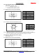
Rikaline GPS-6017 Operating Manual 3.4.1 A-6011 Mini Din Female and PS-2 male connector: Cable Length: To GPS-6017: 1 meter RS-232 to PS-2: 45 cm Note: PS-2 with long cable (1 meter) is for GPS PS-2 with short cable (45mm) is for power 3.4.1.1 Mini Din Female connector function definition: Pin 1 2 3 4 5 6 7 8 9 3.4.1.2 Signal Name N.C Tx Rx N.C Ground N.C N.C N.C DGPS in N.C = No connection PS-2 male connector function definition (to PC): Pin Signal Name 1 +3 ~ +6V 2 N.C 3 N.C 4 Ground 5 N.C 6 N.C N.
Rikaline GPS-6017 Operating Manual 3.4.3 A-6031 USB Cable The function definition of the A Type USB connector is as follows: Pin 1 2 3 4 3.4.4 A-6014 High power connector DGPS (Orange) (Build on Demand) 3.4.5 Signal Name +5V D+ DGround A-6016 Color Black Red Green White Orange VCC (Red) Tx (Green) Rx (White) Ground (Black) Signal Ground +6~30 VDC Tx(RS-232) Rx(RS-232) DGPS IN Optional Cigarette Adapter The optional cigarette adapter with 2-meter core cable is for using in a car or boat.
GPS-6017 Operating Manual Rikaline 4. USB Driver 4.1 System Requirements IBM, Pentium or above and other compatible PC; 16 MB and above memory; Windows 98/Me/2000; VGA Graphic Adapter. 4.2 Installation 4.2.1 Virtual COM Port Driver Installation Windows XP Follow these steps to install the Windows XP VCOM driver: 1. Connect the USB cable between the host computer and the cable target device. 2. Windows will open a “Found New Hardware Wizard” window. 3.
GPS-6017 Operating Manual Rikaline 5. Warranty The GPS-6017 is warranted to be free from defects in material and functions for one year from the date of purchase. Any failure of this product within this period under normal conditions will be replaced at no charge to the customers. 11 Rikaline International Corp. Tel: ++886 2 8973 1899 14F, 171, Chen-Gong Road, SanChong City, Taipei 241, Taiwan Web: www.rikaline.com.tw Fax: ++886 2 8973 1896 E-Mail: info@rikaline.com.
GPS-6017 Operating Manual Appendix A Rikaline Software Interface The GPS-6017 interface protocol is based on the National Marine Electronics Association's NMEA 0183 ASC Ⅱ interface specification, which is defined in NMEA 0183, Version 2.2 and the Radio Technical Commission for Maritime Services (RTCM Recommended Standards For Differential Navstar GPS Service, Version 2.1, RTCM Special Committee No.104). A.1 NMEA Transmitted Messages The GPS-6017 supported by SiRF Technology Inc.
GPS-6017 Operating Manual Rikaline A.1.2 Geographic Position with Latitude/Longitude (GLL) Table A-4 contains the values for the following example: $GPGLL,3723.2475,N,12158.3416,W,161229.487,A*2C Table A-4 GLL Data Format Name Example Message ID $GPGLL Latitude 3723.2475 N/S Indicator N Longitude 12158.3416 E/W Indicator W UTC Position 161229.487 Status A Checksum *2C Units Description GLL protocol header ddmm.mmmm N=north or S=south dddmm.mmmm E=east or W=west hhmmss.
GPS-6017 Operating Manual Table A-8 GSV Data Format Name Example Message ID $GPGSV Number of Messages 2 Message Number 1 Satellites in View 07 Satellite ID 07 Elevation 79 Azimuth 048 SNR (C/No) 42 .... ....
GPS-6017 Operating Manual Reference Speed Units Speed Units Checksum M 0.13 N 0.2 K *6E Knots Km/hr Rikaline Magnetic (1) Measured horizontal speed Knots Measured horizontal speed Kilometers per hour End of message termination (1) SiRF Technology Inc. does not support magnetic declination. All “course over ground” data are geodetic WGS84 directions. A.2 RTCM Received Data The default communication parameters for DGPS Input are 9600 baud, 8 data bits, stop bit, and no parity.
GPS-6017 Operating Manual Appendix B Rikaline Earth Datums & Output Setting B.1 Earth Datums The GPS-6017 is built in earth datum with WGS84. B.2 Setting B.2.1 Manufacturing Default Datum: WGS84. Baud Rate: 9600. Output: GGA, GSA, GSV, RMC, VTG. WAAS/EGNOS: OFF (Optional ON is for the area covered by WAAS/EGNOS) B.2.2 Baud Rate and Output Sentences Setting B.2.2.1 By SiRFdemo Program 1// Connect your GPS-6017 to PC (either COM or USB) 2// Execute SiRFdemo.
GPS-6017 Operating Manual Appendix C Rikaline Ordering Information C.1 Product Options C.1.1 OutPut Level (or Data) GPS-6017: RS-232 & TTL (Standard) With 2-meter Cable and PS-2 Female Connector. C.1.2 Color Option BK Black (Standard) Other Color: by demand C.2 Accessories C.2.
GPS-6017 Operating Manual Seq. 31 32 33 Part No. A-6017-T2 A-6017-X A-6017-X1 Rikaline Appl. Model Toshiba E-330/740 O 2 – XDA / T-Mobiles – MDA MDA II Remarks: All A-6017 series Cigarette Adapters are up to 2A and with certificate of CE, FCC and e mark no. 021433. All A-6012 series Cigarette Adapters are up to 850mA with certificate of CE, FCC and e mark too. C.2.