
User Guide


RS-LiDAR-16 User Manual
49
Appendix C ▪ RSView
This appendix gets you started with RSView. It shows you how to use the application to acquire,
visualize, save, and replay sensor data. You can examine sensor data with other free tools, such as
Wireshark or tcp-dump. But to visualize the 3D data, use RSView. It’s free and relatively easy to use.
The version used this time is RSView3.1.5.
C.1 Features
RSView provides real-time visualization of 3D LiDAR data from RoboSense LiDAR sensors. RSView
can also playback pre-recorded data stored in “pcap” (Packet Capture) files, but RSView still does not
support pcapng files. RSView displays distance measurements from a RoboSense LiDAR sensor as
point data. It supports custom-colored display of variables such as intensity-of-return, time, distance,
azimuth, and laser ID. The data can be exported as XYZ data in CSV format. The previous versions of
RSView do not support generating point cloud files in LAS, XYZ, or PLY formats, while the RSView 3.1.5
supports generating LAS format.
Functionality and features include:
Visualize live streaming sensor data over Ethernet
Record live sensor data in pcap files
Visualize sensor data from a recording (pcap file)
Interprets point data such as distance timestamp, azimuth, laser ID, etc.
Tabular point data inspector
Export to CSV format
Ruler tool
Display multiple frames of data simultaneously (Trailing Frames)
Display or hide subsets of lasers
Crop views
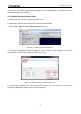
C.2 Install RSView
Installer for RSView is provided for Windows 64-bit system and it has no need for other dependencies.
You can find the executable installer RSView_X.X.X_Setup.exe from the U disk in the RS-LiDAR-16
box. Also you can download the latest version from RoboSense website
(http://www.robosense.ai/resource). Launch the installer and follow the on-screen instructions to finish
the installation.
C.3 Set up Network
As mentioned in the RS-LiDAR-16 User’s Manual, the default IP address of the computer should be set