
User manual


Interference Analyzer
R&S
®
Spectrum Rider FPH
253User Manual 1321.1011.02 ─ 05.00
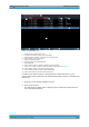
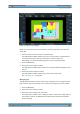
The R&S Spectrum Rider unchecks / checks the checkbox at the "Include" column
and removes / adds it on the map
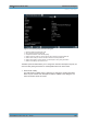
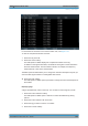
Saving measurement data
When you are done with the measurement, you can save the measurement data in
a .gpx file for later evaluation in the R&S InstrumentView or other applications like
Google Earth.
1. Press the MEAS key.
2. Select the "Indoor Position" softkey.
3. Select the "Save Results" menu item.
The R&S InstrumentView stores the measurement data in a GPX file (it does not
matter if you have specified any GPS data in your map). When you are done with
the measurement, you can save the measurement data in a .gpx file for later eval-
uation in the R&S InstrumentView or other applications like Google Earth.
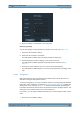
Restoring measurement data previously recorded
In the same way, you can also restore a GPX file that you have saved previously.
1. Press the MEAS key.
2. Select the "Indoor Position" softkey.
3. Select the "Select GPX File" menu item.
The R&S Spectrum Rider restores the measurement data saved in the selected
GPX file. You can then add or remove tags as required.
If you have specified the GPS reference points for the indoor map, you can also
load the measurement data into a different map. (For example, a larger scale floor
plan of a building or embed the indoor data into an outdoor map).
To do so, load a different map via the "Map" softkey and load the corresponding
GPX data. If the map and GPX data are not compatible, the R&S Spectrum Rider
will not display the measurement data stored in the GPX file.
Note that you have to load the map first before restoring the GPX file.
If the GPX data is not compatible with the currently displayed map or does not con-
tain any GPS information, the R&S Spectrum Rider shows a corresponding mes-
sage.
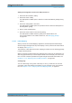
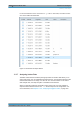
11.3.6 Analyzing Geographic Data
The R&S InstrumentView software package provides an interface that allows you to
export and review your recorded data with Google Earth. This interface trans-
forms .gpx files into ".kmz" files (required by Google Earth). It also contains a plug-in
that illustrates the signal levels measured at the GPS coordinates that you have added
to the .gpx file.
Working with Maps