
User manual

Getting Started – Maps
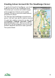
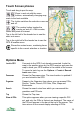
When you start ViewRanger it will show the Map view and will centre on one of
the maps.
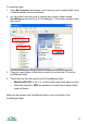
If you cannot see a map, choose Options > Organizer, go to the Maps section,
highlight a map, press the cursor pad centre or button and choose View.
Use the arrow keys ◄►▲▼ to pan around the map. On touch phones touch
and drag the map to pan.
Use the * key to zoom in to the map and use the # key to zoom out. On touch
phones press the zoom in and out buttons. You can also zoom in and out by
going to Options > Display.
If you have more than one scale of map installed then as you zoom in and out
ViewRanger will show the most appropriate scale. You can switch this
automatic scale off using the cursor pad centre or button then Map scale &
zoom > Auto scale off.
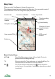
To connect to a GPS and lock the map to the GPS position press Lock to GPS
or simply press 2. As you move the map will automatically pan to keep the GPS
location in the centre of the screen. The GPS position is shown as a red circle
with a cross in the middle.
If you pan the map (using the cursor keys or by touching and dragging), the
map will no longer be locked to the GPS position. The position will still be
shown as a red circle.
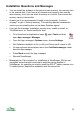
The cursor mode is indicated by an icon in the header bar. The icon <G> means
that the display is locked to the GPS and the icon <P> means that the display is
being panned. Other modes are explained later.
To see a panorama from the current position, press the cursor pad centre or
button to see the context menu and choose Panorama from here.
16