
User Manual

Configuring graphical maps – using the MapMaker
21
Siemens Building Technologies 048_DMS_DMS8000_Graphical_Map_Configuration_MP4.30_A6V10062441_a_en
Fire & Security Products 06.2010
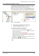
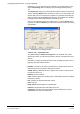
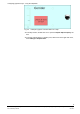
Fig. 12 Area controls
A Select the interior squared dot to move and rotate the entire polygon
B Select the peripheral squared dots to reshape the polygon
5. Right-click once more on the camera point.
6. Select Hide coverage area in the menu that appears.
Note: If you need to modify the area, show it again and repeat this procedure.
7. Repeat steps 1-6 for all cameras.
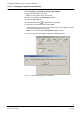
Camera visibility: You can define specific layers on which cameras will be visible
during runtime (default is All layers). Proceed as follows:
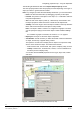
1. Double-click the camera object to display the Graphic Object Property window.
2. Select the Visibility tab.
3. De-select All layers and check the desired visibility layers.
4. Close the window.
Note: You can modify this at any time by repeating the above procedure.
For more information on graphic object properties and how to modify them, see sec-
tion 2.3.7 on page 23.
A
B