
User guide


Rev 2.0 C Aug.10 89
9
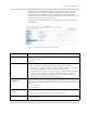
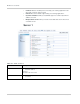
9: GPS Configuration
• GPS
• Server 1
• Server 2 to Server 4
• Misc
• Local/Streaming
The GPS tab that displays in ACEmanager, is applicable across all
Sierra Wireless AirLink devices.
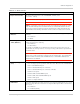
GPS
This group includes commands specific to GPS features and the
AirLink Device.
The AirLink device is equipped with a Global Positioning System
receiver (GPS) to ascertain its position and track the movements of a
vehicle or other devices which move. The AirLink device relays the
information of its location as well as other data for use with tracking
applications.
Tracking Applications used with Sierra Wireless PinPoint line devices:
• Air-Trak
• Track Your Truck
• Tra ck St ar
• DeLorme Street Atlas USA
• Microsoft Streets and Trips
• CompassCom
• Zoll Data
• and many more...
GPS Overview
The Global Positioning System (GPS) is a satellite navigation system
used for determining a location and providing a highly accurate time
reference almost anywhere on Earth. The US military refers to GPS
as Navigation Signal Timing and Ranging Global Positioning System
(NAVSTAR GPS).
GPS consists of a “constellation” of at least 24 satellites in 6 orbital
planes. Each satellite circles the Earth twice every day at an altitude
of 20,200 kilometers (12,600 miles). Each satellite is equipped with
an atomic clock and constantly broadcasts the time, according to its
own clock, along with administrative information including the orbital
elements of its motion, as determined by ground-based
observatories.