
User's Manual


JRV215N
4
WARNINGS AND PRECAUTIONS
WARNING! Please read and follow the following safety precautions. Failure to follow the
instructions below may increase your risk of collision and personal injury.
The Attention – Please Drive Safely! Screen is displayed each time the iGo primo software is
turned ON as a reminder to make use of the systems navigational aids in a safe manner.
Before using the software, read this entire manual. Make sure that you are familiar with the
system’s features and know how to operate the system. Proper use of the iGo primo software
includes the following guidelines:
The iGo primo software is not a substitute for your personal judgment. The route suggestions
should not supersede any local traffic regulation or your personal judgment and/or knowledge of
safe diving practices. Prior to completing any maneuvers suggested by your iGo primo software
(for example, a U-turn or a left turn), verify that you can legally and safely complete the
maneuver. Do not follow route suggestions if they direct you to perform an unsafe or illegal
maneuver, would place you in an unsafe situation, or would route you into an area that you
would consider unsafe.
Glance at the screen only when necessary and safe to do so. Let the computer voice guide you.
If prolonged viewing is necessary, pull of the road to a safe location.
Do not use the iGo primo software to locate emergency services (such as police, fire stations,
hospitals, and clinics). The database may not include all emergency service providers. Use your
own best judgment and ask for directions in these situations.
If the vehicle is in motion, only a passenger should program the iGo primo software. The driver
should not program the system unless the vehicle is parked in a safe location.
The iGo primo software’s map database provides information on suggested routes without
regard to factors that may affect your driving experience or the time required to arrive at your
destination. For example, the system does not reflect road detours, closures, or construction,
some road characteristics (e.g., road surface, slope or grade, weight or height restrictions, etc.),
temporary traffic congestion, weather conditions, and similar factors.
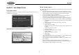
iGo primo software provides turn-by-turn visual and voice assistance to direct you to your
selected destination. The software quickly calculates step-by-step directions to any destination
available on the included navigation map.
The iGo primo software uses Global Positioning System (GPS) satellites, and a digital roadway
map database to calculate and display travel directions. The system’s GPS antenna receives
signals from a constellation of 24 satellites orbiting the earth and uses the strongest signals to
determine your position to within meters.
Vehicle Position
The iGo promo software’s computer considers vehicle speed and heading changes, together
with longitude and latitude information, to accurately determine vehicle heading and position on
a digital map.
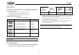
Signals from GPS satellites are used to determine the vehicle location. Three (good) or four
(best) satellites must be received to accurately determine location. The GPS reception status is
indicated by the GPS symbol on the map.
Map and Information Database
The map database used by your iGo promo software was created using high-resolution aerial
and land based data collection.
Car navigation maps are frequently updated. While the database was judged to be as accurate
as possible at the time of its release, a map database can never be 100% accurate. Road
information that is maintained in the map databases, such as turn restrictions or road names
may change over time.