
Item Brochure

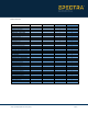

Table Of Contents

https://spectrageospatial.com/survey-office/ Page 3
Aerial Photogrammetry module: Process + create deliverables with Trimble + third-party UAV data in SO + UASMaster (included)
GIS module: Seamlessly integrate GIS data from Survey Pro, TerraSync, + TerraFlex software + connect to external GIS databases
Scanning module: Classify regions, extract features, + create deliverables from third-party point clouds
Tunneling module: Create + edit tunnel models + create customized as-built + geometry reports
Command Aerial Photogrammetry GIS Scanning Tunneling
Adjust Photo Stations
x
Adjustment with Ground Control Points
x
Advanced UAS Adjustment
x
Create Orthomosaic, Point Cloud, + DSMs
x
Delair UX11 Support
x
Hardware Agnostic Support in UASMaster
x
senseFly eBee SODA Support
x
UASMaster v9.x
x
Extract Schema into Feature Libraries
x
Import + Export File Geodatabases
x
Import COR Files
x
Map Metadata
x
Post-process SSF Data
x
Read GIS Data from Data Sources
x
Upload Features to GIS Data Sources
x
Automatic Ground Extraction
x
Automatic Region Classification
x
Create CAD Points from Scan Points
x
Create Orthophoto Images
x
Extract Point Features
x
Georeference Scan Data
x
Import FARO Scan Data
x
Import TZF (Trimble TX6 + TX8) Data
x
Intensity-based Point Cloud Filtering
x
Pairwise Point Cloud Registration
x
Plane-based Point Cloud Registration
x
Assign Point Cloud to Tunnel As-Builts
x
Create + Edit Tunnel Corridors
x
Create Setout Points
x
Custom As-Built Tunnel Reports
x
Draft Plan Sets with Tunnel Geometry
x
Import + Export to Trimble Access Tunnels
x
Render Design + As-Built Tunnel Mesh
x
Tunnel Geometry Reports
x
Bold indicates a new or enhanced feature in Survey Office v5.10.