
User Manual


English
41
The unit used to express the current altitude (meters or
feet) depends on the region (language and country) you
selected in Start>Settings>System tab>Regional Settings.
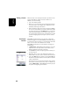
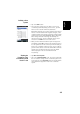
•The Satellites tab displays a polar diagram showing the
locations in the sky of the tracked satellites.
•The Signal tab shows the signal level for each of the
tracked satellites. Green-blue bars indicate satellites used
in position computation. Grey bars only indicate satellites
being received but not used. Red bars on the right
indicate the SBAS satellites that are currently used.
GPS satellites are numbered from 1 to 32. Usually, SBAS
satellites are numbered from 120 to 138.
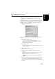
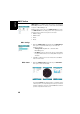
Reset •Open the GNSS Tool Box and double-tap on Reset. A
message directly asks you if you want to reset the receiver
now. Use this option only if you think the receiver is not
working properly.