
User Manual


English
59
• Using the E-compass is recommended for static
occupations (lines/areas in vertex mode and points). The
GPS compass is recommended for trajectories (lines/areas
logged in automatic time or distance mode).
• E-compass readings stabilize after a few seconds. When
logging a point feature after a walking period, please hold
the receiver horizontally and wait a few seconds before
starting logging the feature.
• Tagging a picture file with bearing information: After
taking the picture, you should hold the receiver horizontal
for a few seconds before saving the picture. This will allow
the E-compass to deliver a valid bearing measurement.
Setting an External
Device
After establishing a Bluetooth connection with the external
device used in conjunction with your receiver, do the
following:
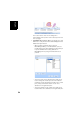
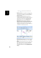
• Tap Menu>Options.
• Tap on the right-arrow button several times until you
unveil the External Devices tab.
• Tap on the External Devices tab.
•In the Type field, select the name of your external device
(3M Dynatel Locator or LTI TruPulse 360).
• Set the virtual port number and baud rate used to let your
receiver communicate with this device.
• Tap ok to enter your settings and return to the map screen.