
Software Instruction Manual
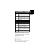
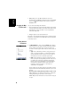
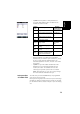
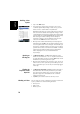
Table Of Contents
- Table of Contents
- Introduction to ProMark Field
- Installing ProMark Field
- Getting Started With ProMark Field
- Creating a New Job
- Importing/Exporting Jobs
- Running a Post-Processed Project
- Using Your Rover in a Real-Time RTK Project
- Changing the Storage Medium for Raw Data Collection
- Initialization
- Logging with Offsets
- Setting an RTK Base
- Installing Geoids
- Adding Background Maps
- E-Compass & External Device
- Index

English
7
• [9]: Area showing a map of the working site (map screen).
Tapping anywhere within this area will return the
horizontal coordinates of the tapped point (expressed in
the coordinate system used in the job). Tap ok to close the
window providing these coordinates.
• [10]: Zoom in/out buttons
• [11]: Battery status
• [12]: Volume setting, for voice guidance (when activated)
• [13]: Phone status
• [14]: Connectivity status.
• [15]: Microsoft Windows button; Used to switch between
the Microsoft Start screen and the ProMark Field
application when ProMark Field is running.
Menu Option Function
Stop Use this option to stop the current logging.
Pause Use this option to pause the current logging.
Stakeout...
RTK only. Use this function to be guided to points you are
requested to go to. Alternately, can be used for navigation
purposes, whether in real-time RTK or post-processed
projects.
Initialize
Use this option to choose one of the available methods to
speed up the initialization process.
Calibration
RTK only. Use this option to determine a local coordinate
system from points the coordinates of which are known in
that system. Available only if a projection is used in the
coordinate system.
Zoom In Increases the scale of the map view by one step.
Zoom Out Decreases the scale of the map view by one step.
Job
Gives access to job-related functions: New, Open, Points
(and Properties if a job is already open).
Configuration
Allows you to set the receiver as a base or a rover and
perform different settings, including setting up the data
link to acquire/generate RTK corrections.
Options
Allows you to access the following settings: Survey, Units,
Feature Codes, Map, View, E-compass, Tolerances,
External Devices, Voice and Keyboard.
Status
Gives access to three tabs describing the current GPS
reception status, in digital (Position) or graphical (Satel-
lites, Signal) form. (In fact the GNSS Status function from
the GNSS Toolbox.)
About Displays the installed version of ProMark Field.
Exit Quits ProMark Field.