
Reference Manual User Manual

GPS Reference Manual
32
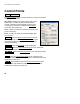
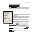
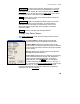
Control Points
The Control Points screen is used to measure or check control points
in the projection solution.
GPS Status
: displays the current solution type, radio
signal quality, number of satellites used, and the
receiver’s estimate of the horizontal precision of the
current point. If this area is tapped, the GPS Status
screen will open (Page R-20).
Point
: is where you enter the name of the control point
you are occupying.
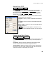
Rover
: is where you enter the measured height of the
rover antenna.
: opens the Rover Receiver Antenna
screen,
which is identical to the Base Receiver Antenna screen
discussed on Page R-29 where the details of the rover
antenna are defined.
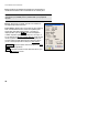
: opens the Projection
screen (Page R-40).
: opens the View Coordinates File
screen, where the
project points can be examined.
: opens the Receiver Session
screen, described on Page
R-76.
: opens the Check Control Point
screen, where the local
coordinate computed from the measurement is compared to the local
coordinates known value.
: when available, opens the Occupy Control Point
screen,
where geodetic coordinates are measured to a point with local
coordinates and stored in the job file.