
ugcs-license-feature-comparison-150321 (1)


!
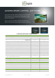
Licence FEATURES COMPARISON
Mission planner | Drone control
Aerial surveying tools:
Waypoints, Linear, Circle, Perimeter, Area Scan tools
Y
Y
Automatic Photogrammetry, Vertical (Facade) scan, Corridor
mapping tools
Y
Y
Automatic Expanding square, Creeping line (SAR) tools
Y
Y
Flying long routes with battery exchange
Y
Y
Immersive 3D mission planning environment
Y
Y
Elevation profile
Y
Y
Telemetry display & Telemetry widget
Y
Y
Automatic flight mode (waypoints)
Y
Y
Manual mode
Y
Y
Joystick and keyboard control
Y
Y
Click & Go
Y
Y
Software emulator
Y
Y
Multi-drone support!
plan and fly multi-drone missions
Y
Y
Post-flight analysis and Image processing
Geotagging
Y
Y
Telemetry player
Y
Y
Custom maps
3D Building import
Y
Y
KML/CSV data import
Y
Y
DEM data import
Y
Y
Geo-referenced images import
Y
Y
No-Fly zones
No-Fly zones - airport registry
Can be disabled
Can be disabled
support@ugcs.com
of v.1503211 2
ugcs.com