
Operation Manual


www.tissot.ch
147_EN
15/16
SAILING-TOUCH
*
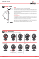
Azimuth
In compass mode, the LCD display of your SAILING-TOUCH indicates the azimuth
(heading)..
Azimuth explanations
The azimuth is the horizontal angle
between the direction of an object
(heading) and True North and is
measured in degrees from 0° to 359°
(e.g.: East = 90°). In compass mode 12
o’clock represents the heading given
by the azimuth relative to True North
(factoring in magnetic declination). You can follow a given azimuth (e.g.: 315°) us-
ing your SAILING-TOUCH. Hold it horizontally in front of you and turn on yourself
until you can read the given azimuth (here 315°) in the LCD: the direction that you
will face at that moment is the direction (azimuth) to follow.
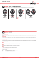
Note 1
For a correct indication of North, it is extremely important to hold the watch as
level as possible.
Note 2
The compass function, like any other com-
pass, should not be used near a metal or
magnetic mass. In case of doubt, you can
recalibrate your compass.
Characteristics of function
Accuracy: ± 8°
Resolution: 2°
Heading
Compass
In compass mode, your SAILING-TOUCH
indicates the True North Pole, factoring in
magnetic declination.
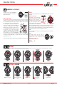
Compass explanations
The vertical lines (meridians) on the Earth converge at the True North Pole (Ng),
indicating its direction. The hand of a conventional compass indicates the direc-
tion of the Magnetic North Pole (Nm). The angle (α) between these two direc-
tions Ng and Nm is known as magnetic declina-
tion. The magnetic declination value depends on
your location on Earth. Furthermore, the Magnetic
North Pole is constantly moving. So the magnetic
declination value also depends on the date. If the
correct magnetic declination value (for the loca-
tion and date) is set (see the setting procedure
on page 14), the minutes hand of your SAILING-
TOUCH will point to True North (Ng). If the mag-
netic declination is set to 0, your SAILING-TOUCH
will point to Magnetic north (Nm). The magnetic declination values and dates
are indicated on topographic charts, or can be found using special software
available on the Internet.
For the whole world: http://www.ngdc.noaa.gov/geomagmodels/Declination.jsp
GLOSSARY > COMPASS
Heading
Azimuth
315
o
Azimuth
315
o
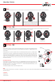
ALARM
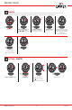
SETTING > ALARM
The 2 alarms are associated with time T1. An alarm lasts 30 seconds, without repeating. When the programmed time is reached,
you can stop the alarm by pressing one of the push-buttons.
Activate glass
Alarm 1 or 2 display
Alarm 1 display
Activate or deactivate
alarm
Alarm 2 display
Setting mode
Alarm rings
Stop alarm
Stop Alarm
Validate setting
1 sec.
2 sec.
or
or
or
or
: time forward
: time backward