
User's Manual
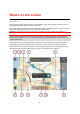
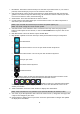
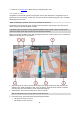
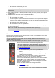

Table Of Contents
- Welcome to navigation with TomTom
- Features
- Get going
- TomTom services
- Connecting a smartphone
- Wi-Fi connection
- What's on the screen
- Traffic
- TomTom MyDrive
- Quick search
- Choosing which search to use
- Using quick search About search
- Entering search terms
- Working with search results
- About postcodes
- About mapcodes
- List of POI type icons
- Planning a route to an address
- Planning a route to a city centre
- Planning a route to a POI
- Planning a route to a POI using online search
- Planning a route using the map
- Planning a route using My Places
- Planning a route using coordinates
- Planning a route using a mapcode
- Planning a route in advance
- Finding a car park
- Finding a petrol station
- Step by step search
- Choosing which search to use
- Using step by step search About search
- Entering search terms
- Working with search results
- About postcodes
- List of POI type icons
- Planning a route to an address
- Planning a route to a POI
- Planning a route to a city centre
- Planning a route to a POI using online search
- Planning a route using the map
- Planning a route using My Places
- Planning a route using coordinates using step by step search
- Planning a route in advance
- Finding a car park
- Finding a petrol station
- Changing your route
- The Current Route menu
- Avoiding a blocked road
- Avoiding part of a route
- Finding an alternative route
- Types of route
- Avoiding features on a route
- Avoiding an incident or route feature using the route bar
- Adding a stop to your route from the current route menu
- Adding a stop to your route using the map
- Deleting a stop from your route
- Skipping the next stop on your route
- Reordering stops on a route
- My Routes
- About My Routes
- About GPX and ITN files
- Saving a route
- Navigating using a saved route
- Navigating to a stop on a saved route
- Adding a stop to a saved route using the map
- Recording a track
- Navigating using a track
- Deleting a route or a track from My Routes
- Exporting tracks to a memory card
- Importing routes and tracks from a memory card
- Map Share
- Speed Cameras
- Danger Zones
- My Places
- About My Places
- Setting your home or work location
- Changing your home location
- Adding a location from My Places
- Add a location to My Places from the map
- Adding a location to My Places using search
- Adding a location to My Places by marking
- Deleting a recent destination from My Places
- Deleting a location from My Places
- Using community POI lists
- Smartphone notifications
- Settings
- Appearance
- Display
- Route Bar
- Guidance view
- Automatic Zoom
- Motorway exit previews
- Route Planning
- Bluetooth
- Wi-Fi
- Updates and New Items
- Maps
- Sounds and Warnings
- Voices
- MyDrive
- Language and Units
- System
- Automatic route recording
- Enable IFTTT service
- About
- Choose a search style
- Quick search
- Step by step search
- Format memory card
- Reset device
- Battery settings
- Your information & privacy
- Use my location and the information I enter to receive TomTom services
- Keep journey history on this device for optional features
- Help
- Getting Help
- Product certification
- UsingTomTom MyDrive Connect
- TomTom account
- Addendum
- Important Safety Notices and Warnings
- Safety messages
- Use with care warning
- Notice for oversized/commercial vehicles
- Proper mounting
- Pacemakers
- Other medical devices
- Device care
- Rating: DC5V, 1.2A
- Environmental and Battery information
- Operating temperature
- Device battery (Non-replaceable)
- Battery waste disposal
- WEEE – e-waste disposal
- Triman logo
- Warning for Australia
- Certification for New Zealand
- Customer support contact (Australia and New Zealand)
- TomTom MyDrive app
- Terms and Conditions: Limited warranty and EULA
- This document
- Model numbers
- CE mark and Radio Equipment Directive for TomTom GO Basic
- EU Specific Absorption Rate (SAR) compliance
- Accessories supplied with this device
- Copyright notices

26
pop-up menu.
Petrol stations that are directly on your route.
TomTom Traffic incidents.
TomTom Speed Cameras and Danger Zones.
Rest stops directly on your route.
You can choose the information you see on your route.
The symbols are in the order that they occur on your route. For traffic
incidents, the symbol for each incident alternates between showing the
type of incident and the delay in minutes. Select a symbol to see more
information about a stop, an incident or a speed camera. If a symbol is
shown on top of another symbol, selecting the symbols zooms in on the
route bar to show each symbol separately. You can then select a symbol.
The total time delay due to traffic jams, weather, and other incidents on
your route, including information provided from historical road usage, is
shown above the symbols.
For a complete list of incident types, see Traffic incidents.
The bottom of the route bar represents your current location and shows
the distance to the next incident on your route. In addition, you can
choose to see the current time if you switch the setting on.
The route bar also shows status messages, for example Finding fastest route or Playing route
preview.
Distances and the route bar
The distance ahead shown on the route bar depends on the length of your route, or the distance
remaining on your route.
For remaining distances longer than 50 km (31 miles), only the next 50 km (31 miles) is shown.
The destination icon is not shown.
Tip: You can scroll the route bar to see your whole route (not available on iOS).
For remaining distances between 10 km (6 miles) and 50 km (31 miles), the complete distance is
shown. The destination icon is shown fixed at the top of the route bar.
For remaining distances of less than 10 km (6 miles) the complete distance is shown. The
destination icon moves down towards the chevron symbol as you get nearer to your destination.
The top half of the route bar shows twice the distance of the bottom half, as shown in the following
examples:
A remaining distance of 50 km on the route bar is split into 34 km (21 miles) at the top and 16
km (9 miles) at the bottom.
A remaining distance of 10 km on the route bar is split into 6.6 km (4 miles) at the top and 3.3
km (2 miles) at the bottom.
The route bar is constantly updated as you drive.
The quick menu
To open the quick menu, select the current location symbol or the speed panel in the guidance
view.
You can then do any of the following:
Mark a location
Note: To make the route bar more readable some incidents may not be shown. These incidents
will always be of minor importance and only cause short delays.