TomTom BRIDGE Reference Guide 14500
Contents Welcome to TomTom BRIDGE 6 Starting TomTom BRIDGE 8 Using gestures 9 Apps on TomTom BRIDGE 10 Connecting TomTom BRIDGE 11 About connecting TomTom BRIDGE ........................................................................... 11 Connect using Bluetooth ........................................................................................ 11 Connect using Portable Wi-Fi Hotspot ....................................................................... 12 Reconnecting your smartphone ....
Language 17 Installing in your vehicle 18 Charging TomTom BRIDGE 19 TomTom BRIDGE not starting 20 Take care of your navigation device 21 Getting help 22 Welcome to navigation with TomTom 24 About TomTom services 25 GPS reception 26 What's on the navigation app screen 27 The map view..................................................................................................... 27 The guidance view ......................................................................................
Planning a route to a POI using search ....................................................................... 49 Planning a route using the map ............................................................................... 51 Planning a route using My Places ............................................................................. 52 Planning a route using coordinates ........................................................................... 54 Planning a route using a mapcode .......................
Settings 82 Appearance ....................................................................................................... 82 Theme Color .................................................................................................. 82 Size of text and buttons .................................................................................... 82 Brightness ..................................................................................................... 83 Arrival information panel ...........
Welcome to TomTom BRIDGE This Reference Guide explains how to use TomTom BRIDGE and the installed TomTom apps. The Reference Guide has the following sections: TomTom BRIDGE The TomTom Navigation app The TomTom Camera app The TomTom Music app Important: For other TomTom BRIDGE settings and operation instructions, and for instructions about other apps installed on TomTom BRIDGE, please refer to the applicable User Documentation. Version 14.
TomTom BRIDGE 7
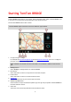
Starting TomTom BRIDGE TomTom BRIDGE starts when it is in its dock, and the dock has power. When TomTom BRIDGE is not in its dock, you can also press the On/Off button until the device starts. The TomTom BRIDGE home screen is shown. Note: The TomTom BRIDGE home screen shown below is an example. The home screen on TomTom BRIDGE might look different and have different apps installed. 1. An app running in a widget.
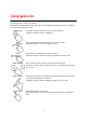
Using gestures You use gestures to control your device. This Reference Guide explains which gestures to use throughout the guide but here is a complete list of all the gestures you can use. Double tap Touch one finger on the screen twice in rapid succession. Example of when to use this: Zooming in. Drag Put one finger on the screen and move it across the screen. Example of when to use this: Scrolling a screen. Flick Flick the tip of a single finger across the screen.
Apps on TomTom BRIDGE TomTom BRIDGE is an Android device that has different apps installed on it. Some of the apps will be standard Android apps, for example a browser, a clock, and a photo gallery. Specialized apps could be added by the device owner, and TomTom has also added apps. Note: TomTom BRIDGE might be locked to prevent you adding your own apps. You can find other apps on the device by scrolling to the right. To see all the apps on the device, select All apps.
Connecting TomTom BRIDGE About connecting TomTom BRIDGE TomTom BRIDGE connects to the internet using your smartphone so you can use the installed apps and access TomTom services. Using your smartphone to connect means that data is sent and received by your smartphone using your cellular service provider. Your smartphone needs to be compatible with TomTom BRIDGE, and you must have a data plan from a cellular service provider. Go to tomtom.com/connect for more information.
7. After you have connected your TomTom BRIDGE to your smartphone, you need to check the box in the Bluetooth profile on the TomTom BRIDGE to enable internet access as shown below. TomTom BRIDGE connects to TomTom services using your phone's internet connection. TomTom services are now active. Connect using Portable Wi-Fi Hotspot Important: You might have additional costs when you use your smartphone to connect TomTom BRIDGE, especially if you are outside the area covered by your data plan.
If you want to connect using another phone, you must connect using Bluetooth or connect using Portable Wi-Fi hotspot for that phone. Tip: If reconnecting automatically to your smartphone using Bluetooth does not work, you can manually reconnect as described in Connect using Bluetooth. Unable to get a connection If TomTom BRIDGE cannot connect to your phone, or you have no internet connection, check the following: Your phone is shown on TomTom BRIDGE.
TomTom BRIDGE features TomTom BRIDGE uses the Android operating system. TomTom and the device owner have changed the operating system in the following ways: Certain Android features have been disabled, either by TomTom or by the device owner. This makes the device safer and easier to use while driving. Some new features and apps have been added, both by TomTom and by the device owner. These additions customize the device, making it relevant for the functions it will be used for.
System bar The System bar is at the bottom of the screen and it contains quick-launch buttons, for example the Back and Home buttons. You can add up to two extra buttons to this bar to quickly start apps that you often use. To add a quick-launch button for an app, do the following: 1. 2. 3. 4. 5. 6. Select the Home button. Select the Settings app. In Settings, select System bar. Under Quick Launch Buttons, select Assign app. Select an app from the list to assign to a quick-launch button.
Go to the Your information app in the All apps menu to read about how TomTom uses your information. If you think that your information is not being used for the purpose for which you have provided it to TomTom, contact us at tomtom.com/support. You can find current and more detailed information at tomtom.com/privacy. Clearing personal data The TomTom BRIDGE device stores your personal data as you use the apps installed on the device.
Language The language used on TomTom BRIDGE is also used on the apps installed on the device. To change the device language, do the following: 1. 2. 3. 4. Select the Home button. Select the Settings app. Select Language & input, then select Language. Select the language you want, then select OK. Your device language changes.
Installing in your vehicle Only use the supplied dock and vehicle mount to hold TomTom BRIDGE when you are using it in your vehicle.
Charging TomTom BRIDGE The battery in TomTom BRIDGE charges when you install the device in its dock and the dock is powered. You can also use a USB Home Charger. You are warned when the battery level is low or critical. You lose your connection to the internet when the battery level is low or critical. When the battery is empty, the device goes into sleep mode. Note: Charging your TomTom BRIDGE using your computer is not recommended. The voltage output of computer USB ports varies by manufacturer.
TomTom BRIDGE not starting In rare cases, TomTom BRIDGE may not start correctly or may stop responding. First, check that the battery is charged. To charge the battery, connect your device to power or install it in the dock. It can take up to 3 hours to fully charge the battery. If this does not solve the problem, you can reset the device. To do this, press and hold the On/Off button until your device begins to restart.
Take care of your navigation device It is important to take care of your device: Do not open the casing of your device under any circumstances. Doing so may be dangerous and will void the warranty. Wipe or dry the screen of your device using a soft cloth. Do not use any liquid cleaners.
Getting help You can get further help by going to tomtom.com/support. For warranty and privacy information, go to tomtom.com/legal.
TomTom Navigation App 23
Welcome to navigation with TomTom This Section explains how you use the TomTom Navigation app. Important: For other TomTom BRIDGE settings and operation instructions, and for instructions about other apps installed on TomTom BRIDGE, please refer to the applicable User Documentation. The navigation app is installed on the device, either as an app that you have to open, or as a software widget on the Home screen.
About TomTom services TomTom services give you real-time information about traffic and safety cameras on your route. To help avoid traffic delays and get you to your destination quicker, you can even use TomTom services on the routes you drive every day. To get TomTom Services on TomTom BRIDGE, connect TomTom BRIDGE to a network. Note: TomTom services are not available in all countries or regions, and not all services are available in all countries or regions.
GPS reception When you first start the navigation app, it may need a few minutes to find your GPS position and show your current location on the map. Make sure you have GPS activated on your device. Tip: The GPS settings are in the device's Settings app. In areas where GPS reception is not possible, such as tunnels, your location may not be accurate. Important: The navigation app cannot give you route instructions until it has received location data.
What's on the navigation app screen The map view The map view is shown when you have no planned route. Your actual location is shown as soon as your device has found your GPS location. You can use map view in the same way as you might look at a traditional paper map. You can move around the map using gestures, and zoom using the zoom buttons.
1. Back button. This button returns the map to an overview of your whole route or, if no route is planned, moves the map to put your current location at the center. 2. Switch view button. Select the switch view button to change between the map view and the guidance view. When in map view, if you are driving, the small arrow rotates to show you your current driving direction, with north being up. 3. Zoom buttons. Select the zoom buttons to zoom in and out. 4. Current location.
When your navigation device starts after sleeping and you have a route planned, you are shown the guidance view with your current location. 1. Switch view button. Select the switch view button to change between the map view and the guidance view. 2. Zoom buttons. Select the zoom buttons to zoom in and out. Tip: On some devices you can also pinch to zoom in and out. 3. Instruction panel. This panel shows the following information: The direction of your next turn. The distance to your next turn.
Note: If your device cannot find your location using GPS or other methods, the symbol appears gray. 8. Route bar. The route bar is shown when you have planned a route. Important: To see a wider route bar showing additional route information, change the setting for Route Information. The route bar The route bar is shown when you have planned a route. It has an arrival information panel at the top, and a bar with symbols underneath.
choose to see the current time if you turn the setting on. Note: To make the route bar more readable some incidents may not be shown. These incidents will always be of minor importance and only cause short delays. The route bar also shows status messages, for example Finding fastest route or Playing route preview. Distances and the route bar The distance ahead shown on the route bar depends on the length of your route, or the distance remaining on your route.
As you approach an exit or crossing, the lane you need is shown on the screen and in the instruction panel. Tip: To close the lane image, select anywhere on the screen or press the back button. To turn lane images off, select the Settings button in the Main Menu, then select Appearance. Turn off the Show previews of highway exits setting. Time-dependent speed limits Some speed limits change depending on the time of day.
Main Menu Navigation buttons On the map view or guidance view, select the Main Menu button to open the Main Menu. The following navigation buttons are available in the Main Menu: Search Select this button to search for an address, a place or a Point of Interest, then plan a route to that location. Current route Select this button to clear or change your planned route. Report Safety Camera Select this button to report a safety camera. My Places Select this button to show your saved places.
Parking Gas Station Select this button to find parking lots/garages. Select this button to find gas stations. Other buttons On the map or guidance view, select the Main Menu button to open the Main Menu. The following buttons are available in the Main Menu screen, in addition to the navigation buttons: Select this button to open the Settings Menu. Select this button to open the Help Menu. The Help Menu contains a guided tour and information about the navigation app.
Select this button to turn on voice instructions. Select this button to reduce the brightness of the screen and display the map in darker colors. When driving at night or when driving through a dark tunnel, it is easier to view the screen and less distracting for the driver if the brightness of the screen is dimmed. Tip: Your device automatically switches between day and night colors depending on the time of day.
Using Quick Search About search You use search to find a wide range of places and then navigate to them. You can search for the following: A specific address, for example, 335 Madison Avenue, New York. A partial address, for example, Madison Ave NY. A type of place, for example, gas station or restaurant. A place by name, for example, Starbucks. A ZIP code, for example, 36925 York for York, Alabama. A city to navigate to a city center, for example, Kingston, NY.
Tip: If you press and hold a letter key on the keyboard, you get access to extra characters if they are available. For example, press and hold the letter "e" to access characters 3 e è é ê ë and more. You can search for a POI (Point of Interest) type, such as a restaurant or tourist attraction. Alternatively, you can search for a specific POI, for example "Rosie's Pizzeria." Note: When searching, the whole map is searched.
A route is planned and then guidance to your destination begins. As soon as you start driving, the guidance view is shown automatically. Tip: If your destination is in a different time zone, you see a plus (+) or a minus (-) sign and the time difference in hours and half hours in the arrival information panel. The estimated time of arrival is the local time at your destination. Tip: You can add a stop to a route that you have already planned. Tip: You can save a route using My Routes.
Near me Select this option to search with your current GPS location as the search center. The results are ranked by distance. In town or city Select this option to use a town or city as the center for your search. You need to enter the town or city name using the keyboard. When you have selected the town or city from the results list, you can search for an address or POI in that city.
Tip: You can switch between seeing the results on the map or in a list by selecting the list/map button: When you select an address from the list of search results, you can choose to show it on the map, add a crossroad or plan a route to that chosen location. To get an exact address you can add the house number. If you show the result on the map, you can use the pop-up menu to add a location from My Places or search near this location.
About ZIP codes You can search using a ZIP code to get closer to the area in which you want to find an address or POI. When you search using a ZIP code, your results include all the streets in a city district, the whole town, or the towns and villages within that ZIP code area. Note: If you search using a ZIP code you will not get a specific address in your results.
Hotel or motel Luxury hotel Campground Economy chain hotel Emergency services Hospital or clinic Dentist Police station Veterinarian Doctor Fire station Car-related services Outside parking Gas station Parking garage Car wash Car dealer Vehicle inspection center Rental car facility Electric/hybrid car charging point(s) Rental car parking Car repair facility Other services Embassy Pet services Government office Telecommunication Company Community service 42
Post office Pharmacy Shopping center Beauty services Tourist information office Shop College or university School Library Convention center Casino Winery Theater Tourist attraction Movie Theater Zoo Concert hall Amusement park Museum Exhibition center Opera Cultural center Nightlife Leisure center Sports Park Swimming pool Education Leisure Sport 43
Mountain peak Water sports Beach Tennis court Park or recreation area Ice skating rink Yacht basin or marina Sports center Stadium Golf course Church Place of worship Railroad station Mountain pass Airport Scenic or panoramic view Ferry terminal ZIP code Religion Travel Note: Not used in all countries.
City center 45
Planning a route Planning a route to an address using search Important: In the interest of safety and to avoid distractions while you are driving, you should always plan a route before you start driving. To plan a route to an address using search, do the following: 1. Select the Main Menu button to open the Main Menu. 2. Select Search. The search screen opens with the keyboard showing. 3. Use the keyboard to enter the name of the place you want to plan a route to.
Towns and roads are shown on the left, POIs are shown on the right. Tip: To see more results, hide the keyboard or swipe the results list to scroll it. Tip: You can switch between seeing the results on the map or in a list by selecting the list/map button: 5. Select an address suggestion. 6. Enter the house number if you have one and haven't entered it already. Tip: If you enter a house number that is not found, the number appears red. The nearest house number that is found is shown in the Drive button.
Planning a route to a city center Important: In the interest of safety and to avoid distractions while you are driving, you should always plan a route before you start driving. To plan a route to a city center using search, do the following: 1. Select the Main Menu button to open the Main Menu. 2. Select Search. The search screen opens with the keyboard showing. 3. Use the keyboard to enter the name of the city or town you want to plan a route to.
5. Select the city in the left-hand column. The city name is shown in the right side of the search input box, and the city center POI is shown below in the right-hand column. 6. Select the city center POI. The city center location is shown on the map. 7. Select Drive. Your navigation device plans a route then starts to guide you to your destination. As soon as you start driving, the guidance view is shown automatically.
2. Select Search. The search screen opens with the keyboard showing. 3. Use the keyboard to enter the name of the place you want to plan a route to. Tip: If you press and hold a letter key on the keyboard, you get access to extra characters if they are available. For example, press and hold the letter "e" to access characters 3 e è é ê ë and more. You can search for a POI (Point of Interest) type, such as a restaurant or tourist attraction.
Tip: You can switch between seeing the results on the map or in a list by selecting the list/map button: 5. Select a POI type or an individual POI. If you selected a POI type, select a POI. The location is shown on the map. 6. To plan a route to this destination, select the drive button: A route is planned and then guidance to your destination begins. As soon as you start driving, the guidance view is shown automatically.
A pop-up menu shows the nearest address. 3. To plan a route to this destination, select the drive button: A route is planned and then guidance to your destination begins. As soon as you start driving, the guidance view is shown automatically. Tip: You can use the location you selected in other ways, such as adding it to My Places, by selecting the pop-up menu button.
2. Select My Places. A list of all your Places opens. 3. Select the Place you want to navigate to, for example Home. Your chosen Place is shown on the map with a pop-up menu. 4. To plan a route to this Place, select the drive button: A route is planned and then guidance to your destination begins. As soon as you start driving, the guidance view is shown automatically.
Planning a route using coordinates Important: In the interest of safety and to avoid distractions while you are driving, you should always plan a route before you start driving. To plan a route using a pair of coordinates, do the following: 1. Select the Main Menu button to open the Main Menu. 2. Select Search. The search screen opens with the keyboard showing. 3. Select the type of search button to the right of the search box. 4. Select Latitude Longitude. 5. Type in your pair of coordinates.
8. To plan a route to this destination, select the drive button: A route is planned and then guidance to your destination begins. As soon as you start driving, the guidance view is shown automatically. Tip: If your destination is in a different time zone, you see a plus (+) or a minus (-) sign and the time difference in hours and half hours in the arrival information panel. The estimated time of arrival is the local time at your destination. Tip: You can add a stop to a route that you have already planned.
A route is planned and then guidance to your destination begins. As soon as you start driving, the guidance view is shown automatically. Tip: If your destination is in a different time zone, you see a plus (+) or a minus (-) sign and the time difference in hours and half hours in the arrival information panel. The estimated time of arrival is the local time at your destination. Tip: You can add a stop to a route that you have already planned. Tip: You can save a route using My Routes.
1. Select the Main Menu button to open the Main Menu. 2. Select Search. 3. 4. 5. 6. The search screen opens with the keyboard showing. Use the keyboard to enter the name of the location you want to use as a starting point. Select an address or POI suggestion. Select Show on Map. Select the pop-up menu button. A pop-up menu shows a list of options. 7. Select Use as Starting Point. 8.
A pop-up menu shows a list of options. 3. Select Remove Starting Point. Your route is replanned with your current location as the starting point. Changing the starting point into a stop 1. Select the starting point on the route in the map view. 2. Select the pop-up menu button. A pop-up menu shows a list of options. 3. Select Change to a Stop. Your route is replanned with the starting point changed into a stop. Finding a parking lot To find a parking lot, do the following: 1.
The map opens showing the locations of parking lots. If a route is planned, the map shows parking lots near your destination. If a route isn't planned, the map shows parking lots near your current location. You can change the screen to show a list of parking lots by pressing this button: You can select a parking lot from the list to locate it on the map. Tip: You can scroll down the list of results using the scroll bar on the right side of the screen.
A pop-up menu opens on the map showing the name of the parking lot. 4. To plan a route to your chosen parking lot, select the drive button: A route is planned and then guidance to your destination begins. As soon as you start driving, the guidance view is shown automatically. Tip: You can add a parking lot as a stop on your route by using the pop-up menu. Finding a gas station To find a gas station, do the following: 1. Select the Main Menu button to open the Main Menu. 2. Select Gas Station.
If a route is planned, the map shows gas stations along your route. If a route isn't planned, the map shows gas stations near your current location. You can change the screen to show a list of gas stations by pressing this button: You can select a gas station from the list to locate it on the map. Tip: You can scroll down the list of results using the scroll bar on the right side of the screen. If you want to change how the search is done, select the button to the right of the search box.
4. To plan a route to your chosen gas station, select the drive button: A route is planned and then guidance to your destination begins. As soon as you start driving, the guidance view is shown automatically. Tip: You can add a gas station as a stop on your route by using the pop-up menu. A gas station that is a stop on your route has a blue icon.
Changing your route The Current Route Menu When you have planned a route, select the Current Route button in the Main Menu to open the Current Route Menu. The following buttons are available in the Current Route Menu: Clear Route Find Alternative Avoid Blocked Road Select this button to clear the currently planned route. The Current Route Menu closes and you return to the map view. You see this button when you have planned a route.
Change Route Type Select this button to change the type of route used to plan your route. Your route will be recalculated using the new route type. Reorder Stops Select this button to see the lists of stops for your current route. You can then change the order of the stops on your route. For a route without stops, you can also select this button to reverse your route. Drive to Route Select this button to plan a route from your current location to the starting point of a My Route.
Shortest route - the shortest route to your destination. This may take much longer than the fastest route. Most eco-friendly route - the most fuel-efficient route. Avoid interstate highways - this type of route avoids all highways. Walking Route - this type of route is optimized for walking. Bicycle Route - this type of route is optimized for bicycles. You can set the default route type in the Settings Menu.
Deleting a stop from your route 1. Press the switch view button to show the map. Your complete route is shown on the map. 2. In the route bar, press the stop you want to delete. The map zooms in to the stop and shows a pop-up menu. Tip: If you select the wrong stop, press the back button to return to the map. 3. Select Delete This Stop. The stop is deleted and your route is recalculated. Reordering stops on a route Note: If you have a route with no stops, you can use this button to reverse the route. 1.
My Routes About My Routes My Routes provides an easy way to create saved routes with optional stops, sometimes known as an itinerary. You can use My Routes to save, retrieve and edit routes. You may want to use My Routes in one or more of the following situations: While working - Your job involves driving several routes with multiple stops on a daily basis. Your routes can change and you need to be flexible and be able to change the order of your stops or change the planned route.
1. In the Main Menu, select My Routes. 2. Select a route from your list. The route is shown on the map view. 3. To navigate to the start of the saved route, select Drive. The starting point of the saved route is converted to your first stop and then the route is planned. Guidance to your destination begins from your current location. As soon as you start driving, the guidance view is shown automatically. Tip: There are two other ways to navigate using a saved route: Select the starting point of the route.
3. Select the pop-menu button to open the menu. 4. Select Add Stop to Route. Tip: Add Stop to Route can also be found in the Manage Stops sub-menu. 5. Select your new stop on the map. Tip: If you know the name of your new stop, you can use Search to select your stop instead of using the map. 6. Select the Add Stop button to add this location as a stop. Your route is recalculated to include your stop.
Traffic About TomTom Traffic TomTom Traffic is a unique TomTom service providing real-time traffic information. For more information about TomTom services, go to tomtom.com/services. In combination with IQ Routes, TomTom Traffic helps you plan the optimum route to your destination taking into account the current local traffic conditions. Your TomTom BRIDGE device regularly receives information about the changing traffic conditions.
The arrival information panel shows the following information: The estimated time that you will arrive at your destination. The length of time to drive to the destination from your current location. A parking button is shown near the destination flag when parking is available near your destination. Tip: If your destination is in a different time zone, you see a plus (+) or a minus (-) sign and the time difference in hours and half hours in the arrival information panel.
Tip: Select an incident on the map to see more detailed information. 1. Traffic incident that affects your route in your direction of travel. A symbol or number at the start of the incident shows the type of incident or the delay in minutes, for example 5 minutes. The color of the incident indicates the speed of traffic relative to the maximum allowed speed at that location, with red being the slowest. The stripes on the traffic jam are also animated to show the speed of the traffic, where appropriate.
To get more information about an incident, select an incident in the route bar. The map opens zoomed in on the incident and a pop-up opens showing detailed information about the traffic incident. The information shown includes: The The The The type of traffic incident - general, accident, road work or lane closure. severity of the incident - slow traffic, traffic lining up or stationary traffic. delay time. length of the incident. For a complete list of incident types, see Traffic incidents.
Safety Cameras About safety cameras The Safety Cameras service warns you about the following camera locations: Fixed safety camera locations. Speed trap locations. Speed trap hotspots. Average safety camera locations. Speed enforcement zones. Red light camera locations. Traffic restriction cameras. The Safety Cameras service also warns you about the following safety hazards: Accident blackspot locations. Traffic jams.
Symbol shown on map Symbol shown in route bar Description Safety camera - this type of camera checks the speed of passing vehicles and is fixed in one place. Speed trap - this type of camera checks the speed of passing vehicles and can be moved to different locations. Speed trap hotspots - this type of warning shows places where speed traps are often used. Average speed safety cameras - these types of cameras measure your average speed between two points.
Changing the way you are warned To change the way the navigation app warns you about speed cameras, select the Sounds and Warnings button in the Settings Menu. You can then set how you want to be warned for the different types of cameras and safety hazards. You can change settings for whether you want to be warned, never warned or warned only if you are speeding. For example, to change how you are warned when you approach a safety camera, do the following: 1. 2. 3. 4.
2. Select Report Safety Camera. You see a message thanking you for adding the camera. Tip: If you make a mistake when reporting a camera, select Cancel in the message. The safety camera is saved on your device automatically, and is also sent to other users. Confirm or remove a speed trap You can confirm the presence of a speed trap or remove a speed trap if it is no longer present. 1. Just after you pass a speed trap, in the route bar you are asked if the camera was still there. 2.
My Places About My Places My Places provides an easy way to select a location without the need to search for the location each time. You can use My Places to create a collection of useful addresses. The following items are always in My Places: Home - Your home location can be your home address or somewhere you often visit, such as your office. This feature provides an easy way to navigate there.
Setting your home location using the map 1. In the Map View, move the map and zoom in until you can see your home location. 2. Select the location by pressing and holding the screen for about one second. A pop-up menu shows the nearest address. 1. Open the pop-up menu and select Add to My Places. 2. In the name bar, enter the name "Home". Note: "Home" must have a capital letter H. 3. Select Add. Your home location is shown on the map.
Adding a location from My Places 1. In the Main Menu, select My Places. 2. Select Add a new place. 3. To select a location, do one of the following: Zoom in on the map at the location you want to select. Press and hold to select the location, then select the add location symbol. Search for a location. Select Show on Map, then select the add location symbol. The name of the location appears in the edit screen. 4. Edit the name of the location so you can easily recognize it. 5.
5. Select Add to My Places. The name of the location appears in the edit screen. 6. Edit the name of the location so you can easily recognize it. 7. Select Done to save your location in the My Places list. Deleting a recent destination from My Places 1. 2. 3. 4. 5. In the Main Menu, select My Places. Select Recent Destinations. Select Edit List. Select the destinations you want to delete. Select Delete. Deleting a location from My Places 1. 2. 3. 4. In the Main Menu, select My Places. Select Edit List.
Settings Appearance Select Settings in the Main Menu, then select Appearance. On this screen, you can change these settings: Switch to night colors when dark Select this setting to make the device automatically switch to night colors when it gets dark. Show previews of highway exits Select this setting to control the full screen preview when you approach highway exits. Switch map view By default, automatic changing of views is on.
Select Size of text and buttons to change the size of the text and the buttons you see on the screen. Note: This feature is only available on devices with a 6 inch / 15 cm or larger screen. Drag the slider to change the text and button size to small, medium, or large, then select Apply this change. Your device restarts and applies the change. Brightness Select Settings in the Main Menu, then select Appearance.
Route Information Select Settings in the Main Menu, then select Appearance. Select Route Information to change settings for the route bar. Show wide route bar if possible The wide route bar is not shown by default. You can select this setting to turn on the wide route bar in the guidance view. Note: The wide route bar can only be shown if the screen is wide enough. When the wide route bar is shown, you see more information about your route. For example, you see time and distance to traffic and more.
Voices Select Settings in the Main Menu, then select Voices. Choosing a voice Select Choose a voice to change the voice that gives spoken directions and other route instructions. A wide range of voices are available. There are computer voices which can read street names and other information directly from the map and there are recorded voices which have been recorded by actors. Note: Computer voices are not available in all languages.
Route Planning Select Settings in the Main Menu, then select Route Planning. When a faster route is available If a faster route is found while you are driving, TomTom Traffic can replan your trip to use the faster route. Select from the following options: Always take the fastest route Ask me so I can choose Don't ask me Always plan this type of route The types of route you can choose from are as follows: Fastest route - the route which takes the least time.
Hear only warning sounds. None No warning sounds are given. Safety camera warnings Select Settings in the Main Menu, then select Sounds & Warnings. Select Safety camera warnings. You can then set how you want to be warned for the different types of cameras and safety hazards. You can change settings for advance warning time and whether you want to be warned, never warned or warned only if you are speeding. Safety warnings Select Settings in the Main Menu, then select Sounds & Warnings.
Select this setting to choose the units used on your device for features such as route planning. If you want the units to be set by the GPS, select Automatic. Language The language used on TomTom BRIDGE is also used on the apps installed on the device. For example, the language used for buttons and menus in the navigation app is the same as the language you selected in your device settings. You can change the device language in Language & input in the TomTom BRIDGE Settings app.
Getting Help Help Select Help from the Main Menu or the Settings menu. On this screen, you can see the following information: Guided tour Select this option to get a short tutorial on how to use your navigation device. About This is an information screen rather than a setting and shows you information about your TomTom BRIDGE. You may be asked to go to this screen during a call to TomTom Customer Support or you may need to enter information taken from this screen when using the TomTom Shop.
External Camera App 90
Using the External Camera app This section explains how to use the External Camera app. Important: For other TomTom BRIDGE settings and operation instructions, and for instructions about other apps installed on TomTom BRIDGE, please refer to the applicable User Documentation. The app shows you the live image from the external camera installed on your vehicle. Note: A rear-view camera usually turns on when you shift into reverse. Other external cameras are turned on by a switch on the vehicle dashboard.
TomTom Music App 92
Using the TomTom Music app This section explains how to use the TomTom Music app. Important: For other TomTom BRIDGE device settings and operation, and for instructions about other apps on the device, please refer to the applicable User Documentation. Use the Music app to select and play music stored in the device's internal memory, or on the memory card that you have inserted in the TomTom BRIDGE. Select the Music button to start the app.
Addendum Important Safety Notices and Warnings Global Positioning System (GPS) and Global Navigation Satellite System (GLONASS) The Global Positioning System (GPS) and Global Navigation Satellite System (GLONASS) systems are satellite-based systems that provide location and timing information around the globe. GPS is operated and controlled by the Government of the United States of America, which is solely responsible for its availability and accuracy.
Keep a safe distance from the vehicle in front. Before setting off on a motorcycle, fasten your helmet correctly. When riding a motorcycle, always wear protective clothing and equipment. When riding a motorcycle, be extra vigilant and always ride defensively. Rating: 5V DC, 2.0A How TomTom uses your information Information regarding the use of personal information can be found at tomtom.com/privacy. Battery This product uses a Lithium-Ion battery.
Only use the battery with a charging system that has been qualified for use with the system per this standard. Use of an unqualified battery or charger may present a risk of fire, explosion, leakage or other hazard. Do not short circuit a battery or allow metallic conductive objects to contact battery terminals. Replace the battery only with another battery that has been qualified with the system per this standard, IEEE-Std-1725-200x.
FCC information for the user THE DEVICE COMPLIES WITH PART 15 OF THE FCC RULES Federal Communications Commission (FCC) Statement This equipment radiates radio frequency energy and if not used properly - that is, in strict accordance with the instructions in this manual - may cause interference to radio communications and television reception.
Emissions information for Canada Operation is subject to the following two conditions: This device may not cause interference. This device must accept any interference, including interference that may cause undesired operation of the device. Operation is subject to the condition that this device does not cause harmful interference. This Class B digital apparatus complies with Canadian ICES-003. The Country Code Selection feature is disabled for products marketed in the US or Canada.
Model names 4FI70, 4FI72, 4FI73 99
Copyright notices © 2014 TomTom. All rights reserved. TomTom and the "two hands" logo are registered trademarks of TomTom N.V. or one of its subsidiaries. Please see tomtom.com/legal for limited warranty and end user license agreements applying to this product. © 2014 TomTom. All rights reserved. This material is proprietary and the subject of copyright protection and/or database rights protection and/or other intellectual property rights owned by TomTom or its suppliers.